Alaskan Adventure: Days 73 & 74. We traveled 253 miles from Valdez to Tok for a one night stay at Sourdough Campground. The next morning we set out for Chicken on the Taylor Highway. It is only 66 miles from Tok to Chicken but much of it is a long, slow, bumpy, dusty road! The next morning we set out for Dawson City, also nicknamed “the City of Gold”. That highway is called “Top of the World”
August 12: We wished we had another day in Valdez instead of a long drive back over some roads we had already traveled. Leaving Valdez was sort of sad because it felt like “the beginning of the end” of our Alaska trip. We still had two weeks left but Valdez was the last overnight stay along the beautiful Alaska coast. From Valdez back to Glennallen on the Richardson Highway was a repeat but from Glennallen to Tok was new road. The next several pics are of travel to from Valdez to Tok.


Had to stop again to take pics as we went past the beautiful mountain ranges of Wrangell-St. Elias National Park.

We stopped along the road to watch Trumpet Swans in a pond.


Trumpeter Swans were once considered endangered but have made a comeback. Vibrant red something growing nearby.
Dashcam video. Nothing particularly special, just a reminder of the beauty of traveling the Richardson Highway from Valdez to Tok.
We only stayed one night in Tok, at the same campground (Sourdough) we had stayed at earlier in the trip on the way into Alaska. Now we were headed out of Alaska.
August 13: The drive from Tok to Chicken was one of the shortest milewise but one of the longest timewise. Lots of washboard dirt road. The scenery was great but couldn’t look at it very long because you had to watch the road. Try to speed up a bit then hit the brakes when the washboard starts up again and the RV dashboard starts bouncing. Only 77 miles but we only averaged about 10mph. The first and only town between Tok and Chicken is called Tetlin Junction. From there on, mostly north, for 65 miles there is literally nothing but Alaskan wilderness and dirt road. Beautiful but kinda scary.

Wild mountain scenery from Tok to Chicken.


We got to see MOOSE finally! They were in a pond, right alongside the dirt road. Seeing this made the bad road seem more worthwhile.


Hated to leave this spot watching the moose but we were stopped right in the road and close to a one lane bridge so we eventually had to move on. Only one car came by during the 20 minutes we were there which gives you some idea of how remote this is.

A paved pullover area for a break and to read information signs.
Dashcam – driving the Taylor Highway. Driving these roads will be a memory that sticks. It may not seem difficult to watch the video but to dodge and weave for hours took a lot of concentration. We were all worn out by this road.
Where bad pavement meets bad dirt and washboard.


There are places you can stop and pan for gold. This location was protected by hordes of mosquitos.

Not a great sign but shows the Taylor Highway which continues on north to Eagle and where it splits off east to become the Top of the World Highway and cross the border into Canada. Continues on to Dawson City where it crosses the Yukon River.

Took this mostly for the “You are Here” note and how far north toward the Arctic Circle we were. Chicken and Dawson City are only about 170 miles from the Arctic Circle (straight line, about 600 miles driving).
The Great Northern Forest (green): Called “Taigo” in Russia, the boreal (northern) forest extends around the top of the world. White and black spruce, paper birch, quaking aspen and balsam poplar are the dominant trees in Alaska’s boreal forest.
Another video of the road to Chicken. This is the Only road to Chicken. They call it a Highway. The “Taylor Highway”. Never complain about our Highways…

Entering Chicken, this is the official welcome/directions signage.
How did the town get the name “Chicken”? From the town’s own website: In the late 1800’s, early miners traveled far in search of gold. Food was sometimes scarce, but a particular area near the South Fork of the 40-Mile River was abundant in Ptarmigan, now the state bird which bears a resemblance to a chicken (Ah the foreshadowing is thicker than steel.) The miners kept themselves alive with the help of the Ptarmigan (if you consider being eaten as helping.) In 1902, Chicken was to become incorporated, the second town in Alaska to do so. The name “Ptarmigan” was suggested. Many people liked the name, but felt the quotation marks were too presumptuous. The name was shortened to Ptarmigan. The only problem was that nobody could agree on the correct spelling. They didn’t want their town name to be the source of ridicule and laughter, so they decided on “Chicken.” (The irony is thicker than the foreshadowing.)

Our campsite (way in the background) along Chicken Creek.


Chicken Creek and abandoned gold dredge.

Abandoned Pedro Gold Dredge, or F.E. Company Dredge Number 4. This dredge was originally built in California, shipped to Pedro Creek (north of Fairbanks Alaska) and assembled to mine gold in 1938. In 1959, when the gold there ran out, The Fairbanks Exploration Company took the million pound dredge apart and shipped it piece by piece to Chicken over the Alaskan and Taylor “Highways”. It mined gold on Lower Chicken Creek from 1959 to 1967. I was thinking gold mining by dredge was ancient history but I was born in 1955 and 12 years old when this thing quit running. I guess I am ancient history.

Most of our group took a walk up the hill to tour the abandoned buildings of “Old Chicken”. The short section of paved road turns into dirt at the corner ahead. It messes with your head to just start walking up “The Highway” but there is that little traffic and except for truckers mostly slow moving.

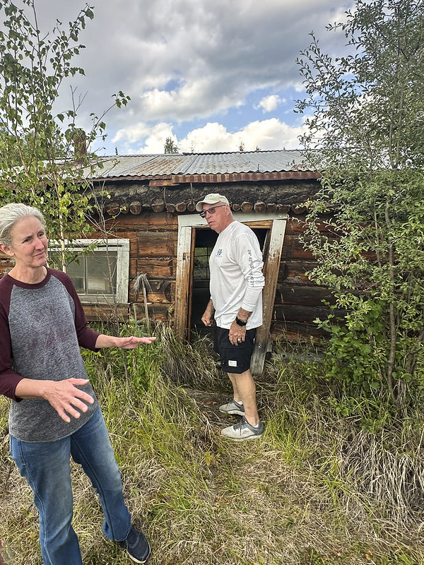
An abandoned steam shovel and our tour guide explaining the weed overgrown Old Chicken buildings. Mike Z. is checking out the door into the old “General Store”.


This is what remains of the “Chicken General Store”. It was owned by John Powers who is “Mr. Strong” in the book “Trisha”

I stuck the phone through the door to take this pic. The walls have sunk into the permafrost ground so far that the floor is at the windows.

This is the remains of a rather famous schoolhouse in Old Chicken. It was originally built as two stories and was the “Chicken Creek Hotel” before being converted into a one story schoolhouse. In 1927, 19 year old Anne Hobbs arrived in Chicken to teach children. She only lasted a few years before the local people ran her off because she wanted to include teaching the native Inuit children too. Inuit could not pronounce “Teacher” so they called her “Tisha”. The 1976 novel “Tisha: The Story of a Young Teacher in the Alaska Wilderness” describes her experiences.

This is the room that Anne Hobbs lived in while teaching at the Chicken School. It is about 1/3 of the school building. Below is a short autobiography she wrote. Her name changed to Anna Purdy after she married a gold miner named Fred Purdy. This was also scandalous because he was half-Inuit.
I was born around 1908 in the back country of Prownington, Missouri. I was teaching in Oregon when I was given an offer to go to Alaska to teach. I have taught in many places such as Franklin Creek (3 years), Chenin (1 year), Tetlin Indian Village or reservation, Dot Lake and Eagle (6 to 7 years). Also taught in the desert in Claifornia at 29 Palms to wayward children, and Chicken, Alaska for 10 years to ten pupils.
In Eagle I married Fred Purdy and during the following years legally adopted 10 children. Chuck, Ethel, Doris, George, Marie, Eddie, Jack, Hank, Lynn and Barbara. Fred was a miner at Meyers Fork. He died in 1965 and was buried next to Doris his daughter. I have been an assistant to the Postmaster, managed road house in Eagle and started the Eagle Library. I am a sourgough of Chicken, Alaska, part and parcel of that great land of gold. I was priviledged to know many of the early sourdoughs before my time. Paul and Jim Bytell, Dick Mitchell, Jack Hawn, Bill Smeter, freigter on river with horse sleds carrying supplies, Ben Norval a very knowledgeable prospector and also a preacher when needed.
I have written two books, “Dark Boundry” in 1954 and “Tisha” in 1976. We live off the Taylor Hwy. at the end of the road in a big yellow house.
Marie became a deep sea diver and now works in a bank at Anchorage. Barbara traveled the world over, a fine geologist, and a professional photographer, lives in Anchorage most of the time. Jack was killed in Vietnam for nothing. Big Ed, a pilot, but made more money as a truck driver in Texas. George a brilliant and now president of oil company in Houston. Ethel lives in Texas as a professional artist and Hank lives in Fairbanks. Chuck died of TB after he had grown up. I have had 4 sons in the armed services. Doris died after, over 10 years of hospitalization and Lynn lives with me spending most of her time knitting.
-Anne Purdy

This is the School Room in the other 2/3 of the building. The floor is almost to the window sills as the outside walls gradually sink into the permafrost ground.

The Chicken chicken.


Chicken chicken and a patch of fireweed with almost no blossoms left – winter is coming.

This is “downtown” Chicken. One gasoline pump covered in stickers and His/Hers public pit toilets.

These three buildings make up the entire “downtown” Chicken. All powered by gasoline generators. There are couple other separate buildings related to campgrounds. It was cool enough that we didn’t need air conditioning which was good because no 30amp was available, just a standard 110 plug-in. There a few people that live in Chicken through the winter. There is a post office that gets mail two days a week by airplane. Our tour guide explained that it is easier to get around in the winter on snow machines. It is always dark, very, very, cold and people mostly stay at home. The Taylor Highway is closed in winter so this is a lonely place.
Chicken Alaska is an odd, quirky, special, place. There’s not much here, but there’s also a lot here. It’s so inaccessible that it has not been “Disneyfied”. It’s an old gold mining town that has been almost, but not completely abandoned because the road needs a place for a few folks to stop for the night. A “ghost town” that is still inhabited. Glad to have visited but no desire to drive those roads again.
August 14: After our one night in Chicken it was time to leave for a shorter, but worse, road from Chicken, Alaska to Dawson City, Yukon Territory. Before leaving we went to the Chicken Creek Cafe for breakfast and hot Cinnamon Rolls fresh out of the oven. Thanks to Starlink they take Visa.
Favorite Bible reading verse for today: Galatians 3:29
“And if you belong to Christ, then you are Abraham’s descendants, heirs according to promise.”

