Seven years ago (2016), while Becky and I were still working, we flew to Spokane, WA. for a whirlwind visit to Glacier National Park and the Canadian Rockies. We met up with Becky’s sisters Jennie and Deanne and Jennie’s partner Roni. That trip was breathtakingly majestic. We all wanted to go back someday. This more leisurely trip with our friends John and Pam Hanson was to be “the longed-for relaxing return visit.” The main goal was to enjoy an extended, unhurried time in the beautiful Jasper (#11 on the map), Kootenay (#12), and Banff areas (#13).
This was the Route map we planned for this trip. We left August 20 and planned to return October 15. We followed the plan up to stop #11 at Jasper National Park. The map below shows the route we took home.The trip to Jasper was as planned up to Jasper National Park (where we were staying at Hinton KOA – #11 on the map). However, after 20 days, including five days at Jasper National Park, we got the terrible news that our son Daniel had died. We left John and Pam and headed straight home to Indianapolis from Jasper; as fast as we could. This revised map shows what we actually did and the sad, anxious 4 day trip back home to family and friends. There is so much that could be said, so many thoughts and prayers on that day and the days since; so much tension between ‘we don’t want to think about it’ and ‘we don’t want to forget’. It has taken so long to get back to this post that many things are jumbled and forgotten. But, up to that point, it had been a good trip with memories we do not want to forget so what follows are photos and memories of the first 20 days.
Part 1 – FROM INDY TO JASPER NATIONAL PARK
First stop – Indiana Dunes National Park/State Park (the campground and nearby areas are a State Park within the larger National Park). This was a stop we added at the last minute when we learned that our friends Bob and Lisa were going to be there and we could visit with them. I was looking forward to visiting Indiana Dunes. I thought I would enjoy lots of memories and ‘Deja-vu’ moments from childhood family weekend visits and camping trips in the sandy campground. Turns out I was wrong. My memories were from the Michigan “Tower Hill” Warren Dunes State Park which is closer to South Bend where I grew up. We stopped on our way to the campground at the National Park Visitors Center to get the stamp for one of America’s newest National Parks. We enjoyed the day and discovered a park I had absolutely no memories of. Unfortunately, on Monday night I began to feel poorly. Tuesday morning I tested for covid and was negative. Two days later I would test positive for covid. The weather started to really get hot so we looked forward to quickly getting further north and cooler temps. To finish the covid saga of the next two weeks; I got it, then when I started feeling better, Becky got it. Providentially, we were both over it by the time we met up with John and Pam in Canada.
Monday, August 21, 2023. All road trips seem to start with a stop at Walmart. In northern Indiana Amish country that includes a horse and buggy with railing to tie-up on.
It was going to be a really hot day so first thing Tuesday morning we went for a walk to the beach with Bob. We followed the “Beach Trail” from the campground to the beach.
Arriving from the trail this is the first view of the beach area. If I had ever seen this before I had completely forgotten.
This building, called The Dunes Pavilion, was originally a bathhouse with a restaurant, concessions, and a rooftop observation deck. It was built in 1929 for $100,000. The history of the “Dunes” area is interesting as the shoreline has been jerked back and forth between industrialization (think Gary steel mills) and conservation. Back in 1899, Stephen Mather, first envisioned a “Sand Dunes National Park” but it took 120 years for it to happen. Indiana Dunes received National Park designation in 2020 as the 61st National Park and the 1st National Park in Indiana.
Propeller from steamship that sank nearby in 1911
J.D. Marshall steamship signage
Becky and Bob exploring the Beach and Dunes
In the foreground is “Dunes Creek” which flows through the campground and out into Lake Michigan. In the background is the restored “Dunes Pavilion”. After our morning walk we went back to the campground, had lunch, and packed up at our campsite #119. We said goodbyes to Bob & Lisa then left early afternoon for Ludington, MI where it was about 10 degrees cooler.
The steep steps down to Lake Michigan from Buttersville Campground in Ludington, MI. We saw some colorful reddish sunsets from this campground which we later figured out were mostly due to the beginning stages of Canadian wildfire smoke in the air. The smoky air would get much worse as we traveled further north.Sunset over Lake Michigan.
Leaving Ludington we headed north, crossing Mackinac Bridge to the Upper Peninsula. No photos but we stayed one night at Fayette Historic State Park, and another night at Frontier Bar & Campground. The UP of Michigan is deeply wooded and beautiful to drive through. We especially enjoyed passing through the town of Escanaba.
Becky driving. She took over as I was feeling pretty sick at this point.
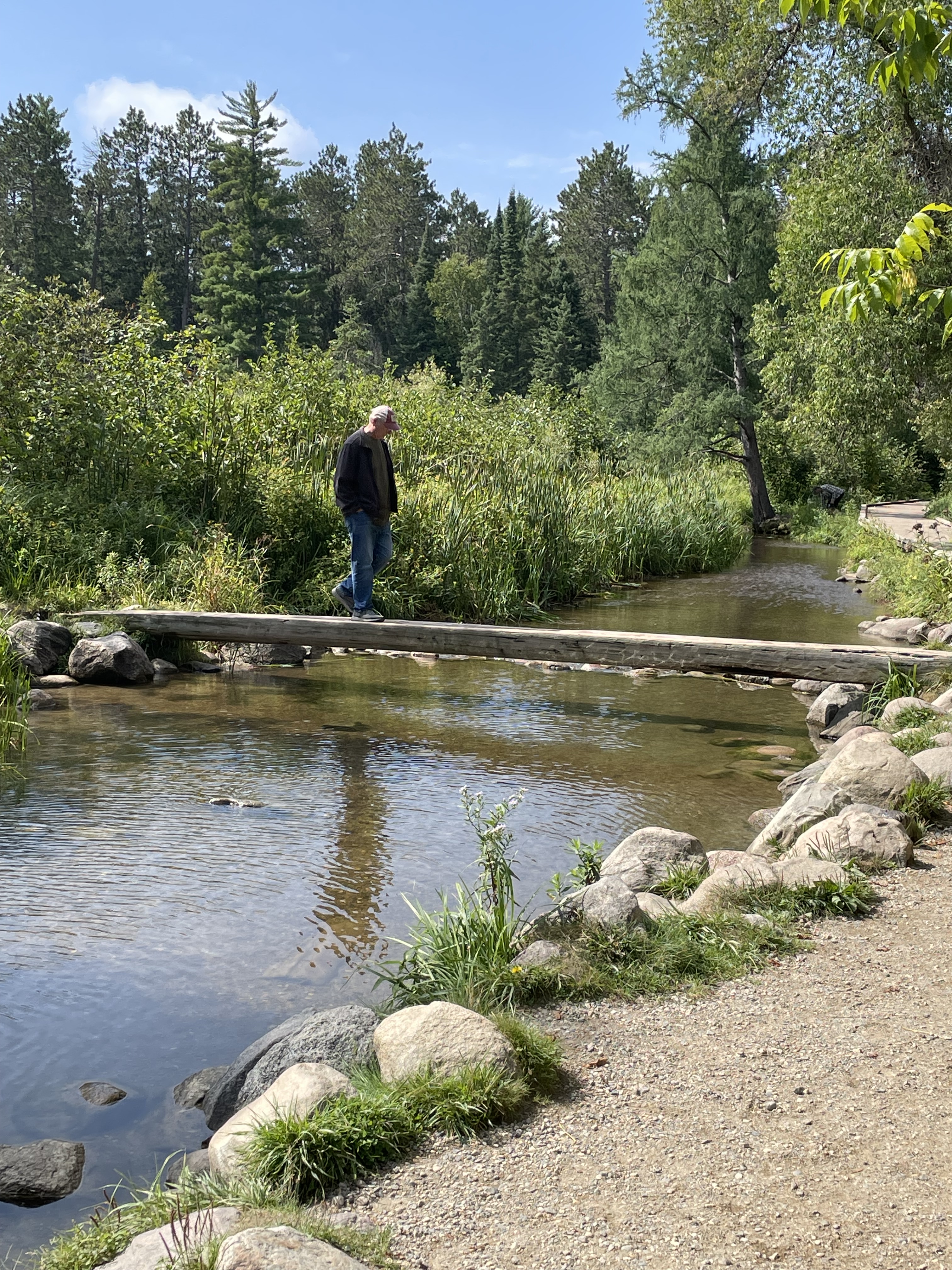
Saturday, August 26 we arrived at Itasca State Park, Minnesota. This is the shallow stream exiting the lake where Lake Itasca becomes the headwaters of the Mississippi River. Hard to imagine this little stream eventually drains 40% of the continental United States (all or part of 31 States).I walked across the Mississippi on a log.
The 1783 Treaty of Paris (signed by Benjamin Franklin, John Adams, etc.) included establishment of the Northwest Territories described as all the land east of the Mississippi River. As the river gets bigger and well defined that’s easy but at the northern end in Minnesota it was hardly clear but very important.
Not a National Park – so not an official NPS stamp – but in my mind a unique State Park with an interesting historical story. After one night at Itasca we went to nearby Bemidji KOA for two nights where we made last minute preparation to cross into Canada and meet up with John & Pam at Winnipeg West KOA. We did laundry and ate meals to use up things we couldn’t bring across the boarder like eggs, chicken, fruits, and vegetables.
Winnipeg West KOA bathrooms
Flowers outside the bathrooms
The land of Ketchup potato chips
Screen capture from my phone showing all the wildfires around where we were heading (Jasper and Banff National Parks are north and west of Calgary on the map). There were no fires directly in the areas we were going but they were all around.
Our motorhome and John & Pam’s travel trailer side-by-side at a rest stop.
River Valley RV Park in Langham, Saskatchewan. This was a really nice stop that we wished we could have stayed another day to enjoy. Beautifully well kept and clean. The only downside was the wildfire smoke was getting really thick so we stayed mostly inside.
Reddish sun seen through dense wildfire smoke.
Doing our part to reduce the Canadian insect population…
Rapeseed fields were abundant in Canada. A genetically modified version of this plant is where Canola oil comes from.
I was reading this book as we traveled. I am convinced this was Providential as it helped prepare my heart to receive news of Daniel’s death.
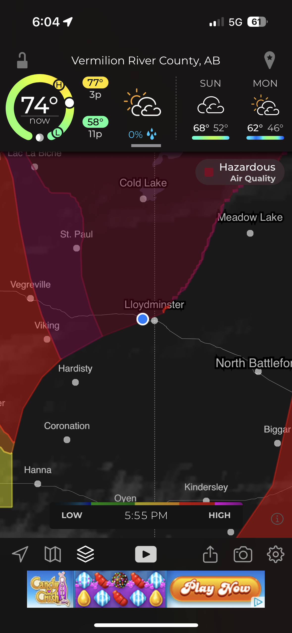
Our last stop before Hinton was “Camp N RV” in Lloydminster. This picture from my phone shows the worst air quality of “Hazardous” that we encountered.
Reddish smoky sky sunset as we arrived at Hinton KOA.
Part 2 – JASPER NATIONAL PARK
Jasper Day 1 – Old Fort Point and Five Lakes Hike
Becky was feeling better but wanted to wait one more day to be certain of not exposing John and Pam to covid. She stayed behind on this first day trip from Hinton KOA into Jasper National Park. The air was still smoky from wild fires but clearer then it had been on the trip into Hinton. The drive each day from Hinton into Jasper National Park (and back) took about an hour but each day the scenery was different and we almost always saw some beautiful sites and lots of wildlife.
The first drive into Jasper resulted in this beautiful bull elk standing majestically along the roadside.
Elk bull and cow showing off for the tourists.
The tourists all stop for the majestic wildlife. The locals get aggravated…
Mountain Goats
We saw Bighorn Sheep on the drive into Jasper. After stopping at the Visitors Center in Jasper and getting some advice on things to see and places to hike we started out to hike to an overlook called Old Fort Point (there was never a fort there).
Stairs at the beginning of hike up to Old Fort Point.
We hiked most of the way up and admired the smoky view of the Athabasca river valley and town of Jasper below. Pam and I were content to stop here but John needed to get to the top so he headed on up. When he came back down I met him and he asked “Where’s Pam?” Seeing she was not where she had been sitting and getting no response to calling out for her, John thought she might have headed up to find him. He hurried up looking for her and I headed down looking for her. Turned out she was just over the hill a little further down so after a bit of panic it all worked out. In that photo: nearly all of the trees in the valley and part of the town of Jasper were burned away in the wildfires summer of 2024.
This is looking up to the top of the overlook. I think that is John talking with a couple other people he met up there. The elevation gain from the bottom of the valley at the stairs to the top is 130 meters (426 feet).
John and Pam reunited and relieved. The next two pics (below) were from across the valley a few days later. They show the ‘hump’ where Pam and I stopped and the top of the overlook where John reached the peak.
Old Fort Point Overlook
Our next stop was the Valley of Five Lakes. We hiked the 9a/9b short loop.
John and Pam taking a break at one of Canada’s “Red Adirondack Chair” scenic locations.
Clear and beautiful lakes.
The lakes are still there but from what I read online the lakes are now muddy and the trees are all burned away after the summer of wildfires in 2024. Grateful to God that we were able to visit Jasper again before the fires.
We saw Bighorn Sheep on our drive back to Hinton.
Jasper Day 2 – Maligne Canyon and Maligne Lake
We were grateful that Becky was with us and the air was less smoky so we could enjoy the Beautiful Mountains and wildlife on the 2nd day.
Up close with Bighorn Sheep.
We really enjoyed Maligne Canyon. This is at the beginning of the canyon where the water is starting to carve down into the rock in smooth pools and eddies.
The next 4 photos show where swirling rocks and water have worn away smooth ‘pot holes’
The canyon hike is beautiful as the water cuts deeper down in waterfalls, sluices, and whirlpools. A series of bridges cross the river. Becky and I hiked to bridge #2 then turned around and returned to the van while John & Pam continued on to bridge #5 where we picked them up.
The name Maligne comes from the French word for ‘wicked’ or ‘evil’. While the English verb maligne is pronounced ‘muh-LINE’, the local Jasper pronunciation of the canyon’s name is ‘muh-LEEN’
Panorama shot stitched together from 10 photos.
View from the “5th Bridge” where we picked up John & Pam.
It had snowed on the mountaintops overnight which just increased the majesty of the surrounding peaks.
Maligne Lake. Becky and I enjoyed the gift shop and restaurant while John & Pam went for a hike.
A storm rolled in and rain started just as they got back from the hike.
Historic Boat House. The Boat House survived the fires of 2024 but much of the surrounding trees and infrastructure did not.
Not sure what bird this is in the bushes by the Boat House but the ‘birder’ lady that pointed it out to me seemed pretty excited about it.
John was driving and said “what else do you want to see?” I said “moose.” A little further down the road John pulls over and says “there you go”…
Mama Moose nursing Baby Moose.
Saw more Elk on the way back through Jasper while returning to Hinton KOA for the night.
King of the road
Jasper Day 3–Athabasca Falls and Sunwapta Falls
More snow during the night on the mountaintops
Saw more Elk along the road coming into the Park.
Athabasca Falls
Incredible amount of water pouring down the canyon.
Tourists
To be so close, to feel the rock foundations vibrate.
And we saw Bears. Up close, probably too close, but they seemed more interested in grazing on leafy greens.
Sunwapta Falls
Sunwapta Falls (means “Turbulent Waters”) is a series of cascading waterfalls.
Jasper Day 4 – Mt. Edith Cavell
The hike from the parking lot is long, steep, and beautiful. A stream follows the path part of the way. Eventually the trees become little short stunted pines above the tree line elevation.
Mount Edith Cavell (3,300 meters=10,800 feet) and Angel Glacier.
Mount Edith Cavell is named after a British nurse executed during World War I for her part in helping Allied prisoners escape occupied Brussels.
Photos below from our visit in summer 2016 compared to 2023.
August 23, 2016
September 7, 2023
Annual lines in glacial ice.
Below: John making careful rock selections (notice the distended pockets) and posing by high elevation pine tree.
John taking a moment to enjoy the mountain views
Stream of meltwater from Angel Glacier
Melting Angel Glacier Waterfalls
We stopped to see a mountainside with lots of bighorn sheep.
A Canadian military plane surprised us as it flew low through the valley on our return trip to Hinton.
Our campsite at Hinton KOA as we prepared to say goodbye to Hanson’s and head home.
Our last drive of the trip as we headed home was back through Jasper National Park and on down the Icefields Parkway, past the Athabasca Glacier, and Banff National Park.
A little post-trip travel analysis: This is all based on only our RV mileage (we traveled lots of other miles in Jasper NP with John & Pam in their van). 4,636 miles according to RVparky route, 4,691 actual miles. 436.25 gallons of gas. Cost – $1,761.77 for average cost/gal $4.04 10.75 miles/gal 22 nights/23 days total = average of 204 miles/day 13 different overnight places/14 days of traveling = 335 average miles per travel day Our longest Travel Days were the days coming home: 1st day: 638 miles from Hinton, British Columbia to Ponderosa Campground, Swift Current, Saskatchewan 2nd day: 362 miles to Old Settlers Park in Burlington, ND (includes border crossing) 3rd day: 623 miles to Stoney Creek RV Resort, Osseo, WI 4th day: 530 miles to Home = 2,153 miles home.