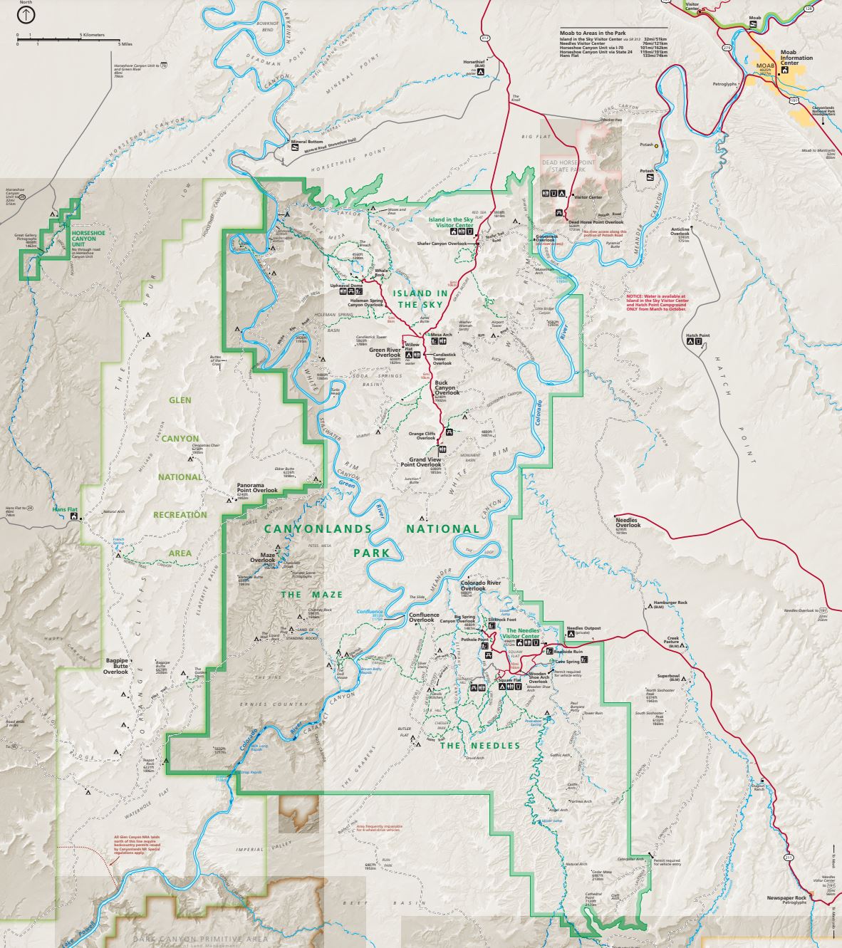
6 of 12 – 2024 Fall Trip West Series. Monday 9/23/24. Canyonlands National Park is Huge. There are two distinct entrances to north and south sections that are completely disconnected by the deep canyons of the Colorado and Green Rivers.
Today we left Moab to visit the southern “Needles” section of the park. A park ranger at Arches highly recommended we visit the “Needles Overlook.” She said “not many people go there because it’s out of the way but it’s worth the drive. You’ll be the only ones there in the morning.” It really is a long, lonely drive, we almost turned around but eventually arrived at an incredible view of why the two halves of the park are not connected.
Leaving the Needles Overlook we went further south and entered “The Needles” section of Canyonlands National Park. The day was filled with all kinds of awesome and unique rock formations.
Leaving “The Needles” we headed north back to Moab stopping at a roadside attraction: Wilson Arch.
After leaving interstate 70 to head south down to Moab the wind picked up and a rain storm blew in. Deanne and Becky were in the rental car. I was driving the RV and trying to stay in my lane when the wind gusted sideways. Fortunately there was not much traffic on the road.
Next morning we headed into Arches National Park with our park visit reservations in hand. First stop, the Visitors Center for restrooms and gift shop.
Becky was delighted when her sisters got her this quilt pattern for a small wall hanging of Delicate Arch. This is a picture of a sample finished product.
Rock cliffs glowing red in the early morning sunshine.
Our first hike on the “Devils Garden Trail” started out chilly and got pretty warm by the time we got done. The trail goes to several scenic sites but the main goal is the thin “Landscape Arch”.
Landscape Arch.
Our next hike was to Skyline Arch Trail. Jennie & Roni at Skyline Arch.
Sand Dune Arch Trail was next. Becky and Deanne navigate a narrow passage.
Delicate Arch Trail was longer and it was getting really hot so we didn’t go all the way to the Arch.
Balanced Rock.
Very tiny, in the center of this photo in the far distance are “The Three Gossips” which was our next stop. The Three Gossips are a 350′ high sandstone rock formation resembling 3 heads in conversation.
The Three Gossips.Duane taking pics. Photo by Deanne.
We went out to dinner in Moab after a long day of hiking and driving through Arches National Park. The onion rings were a big hit.
4 of 12 – 2024 Fall Trip West Series. While at Glenwood Springs, CO for two nights Deanne rented a car that we all would use for our visits to National Parks in Utah, and we visited the Colorado National Monument.
On our travel from Florissant Fossil Beds National Park to Glenwood Springs we saw some beautiful fall colors as the aspens turned bright yellow.
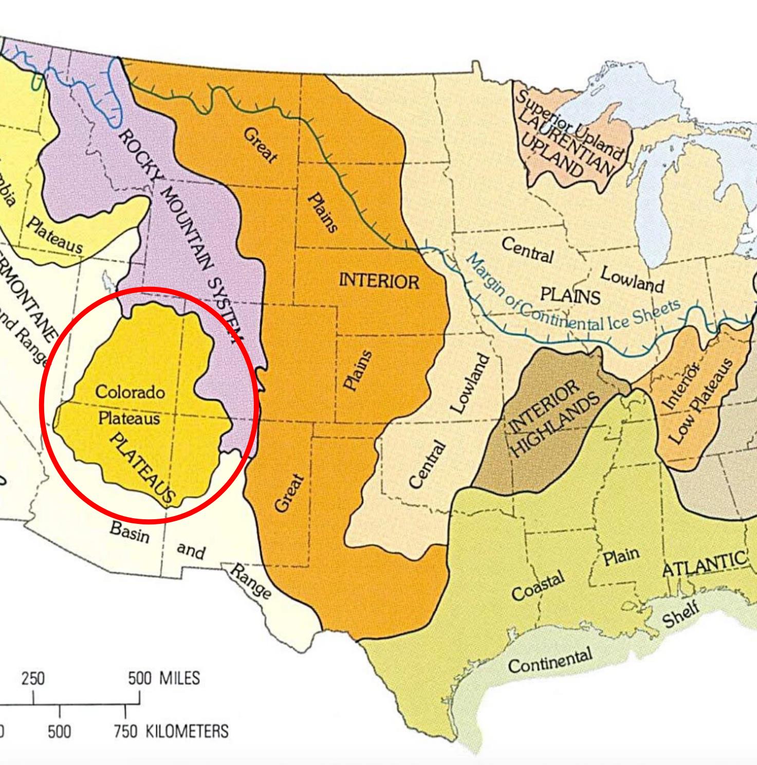
Below is a map of “US Terrain Regions” as mapped by the US Geological Survey. When we left Indianapolis in the Central Lowland Plains, traveling west through the Great Plains, then crossing the Rocky Mountain System, we arrived at the Colorado Plateau(s). I thought we were just headed to a bunch of National Parks in the Utah vicinity. I had no idea there was a name for this densely packed geological wonderland called “The Colorado Plateau”
The Colorado Plateau – “the least tamed area of the lower 48 states.” The Colorado National Monument was the first of many National Parks all included in the Colorado Plateau.
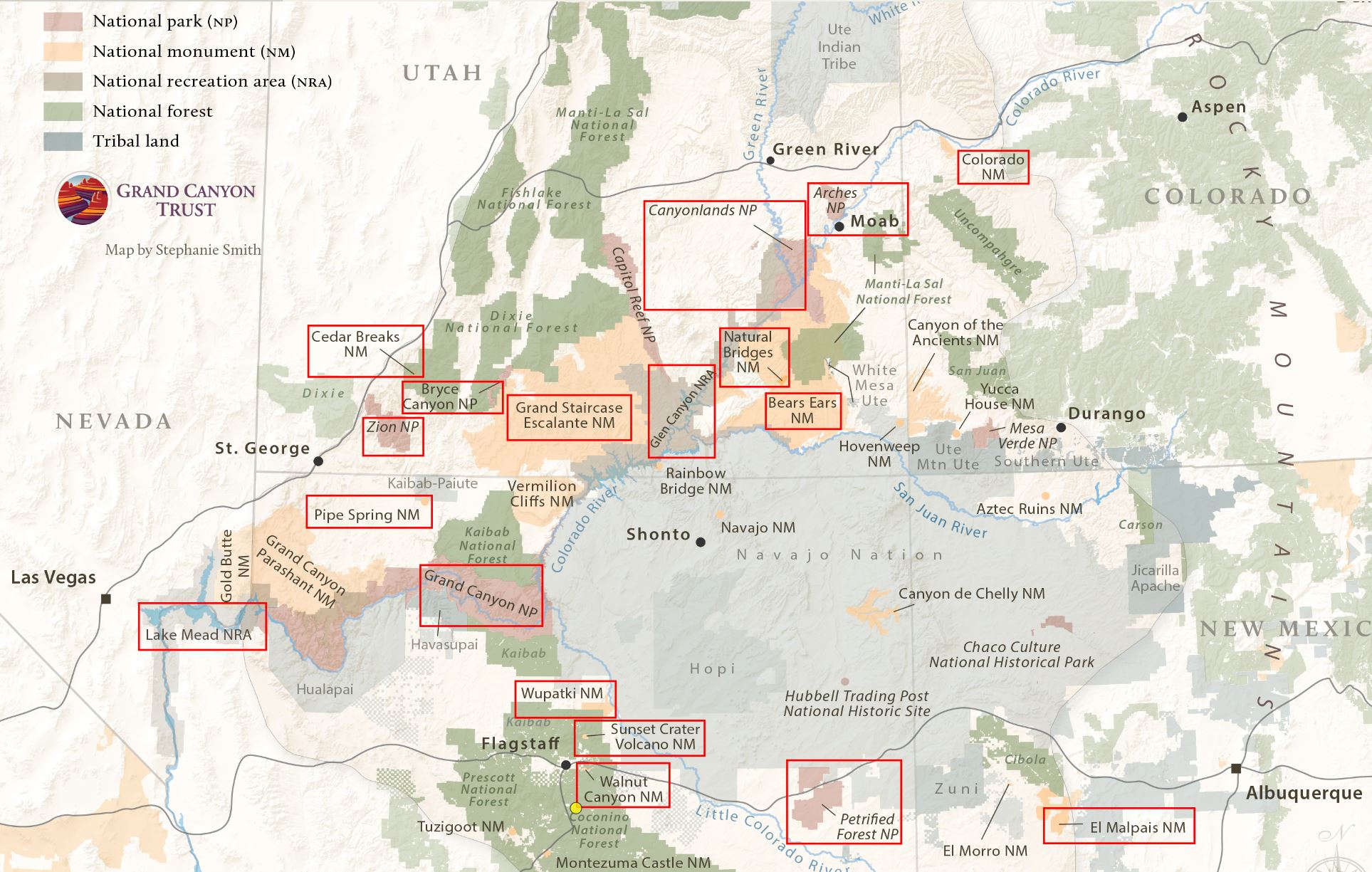
We visited all the National Parks shown on this map except Black Canyon (of the Gunnison) and Mesa Verde. We planned to visit Black Canyon but a bridge on the main road to the park was closed and the park itself was undergoing road repairs. We had seen Black Canyon on a previous trip so we skipped it. This gave us time to visit Colorado Monument which was a phenomenal treat.
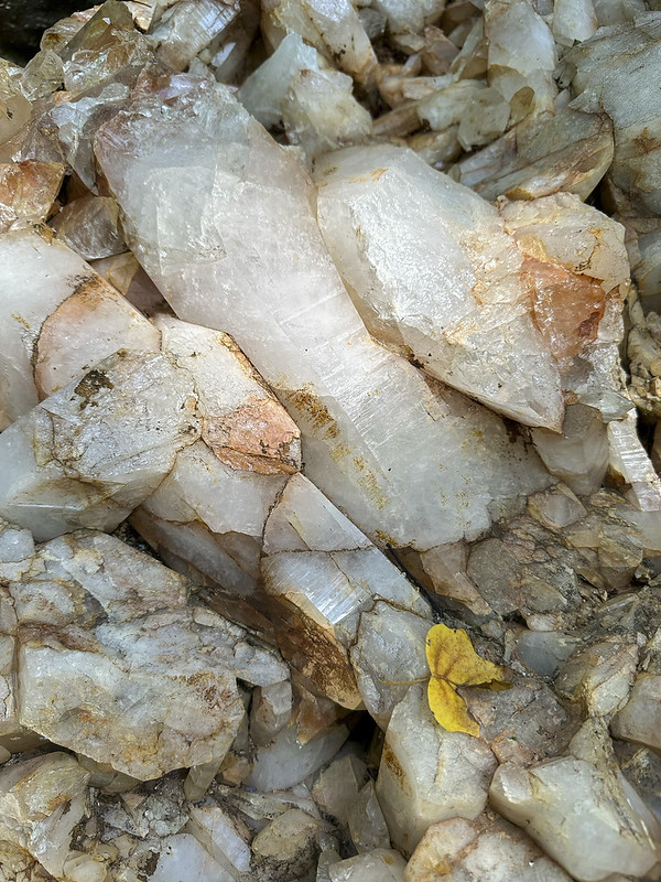
There is only so much you can say about cool rocks and dramatic geology. Since that is what we would be seeing for most of this trip we will not be saying a lot about each picture. It’s a rock, a cool rock, but a rock.
Another map of the Colorado Plateau area; marked with places we visited for National Park Stamps. Starting September 20th at the upper right (Colorado National Monument) we traveled generally counter-clockwise, eventually arriving 20 days later at the Albuquerque Balloon Fiesta October 9th.
The Rental Car: We went to the airport in Grand Junction, CO to pick up a rental car. The first one they gave us had a serious alignment problem so we rejected that one and got an enormous GMC Denali.
Leaving the RV behind for the day, we took the rental car to spend the day driving through Colorado National Monument. It was an amazing day. Jennie had told us it was worth visiting but it does not get near as much publicity as the big Utah National Parks so I wasn’t expecting anything spectacular. It is spectacular.
Hoodoos, Deanne, and the three amigo tourists at Colorado National Monument.
Looking down into the canyon at birds flying below.
3 of 12 – 2024 Fall Trip West Series. This post covers 6 days in Colorado on our way to Utah.
If you look closely at the horizon, THERE ARE MOUNTAINS! After long drives across the flatlands of Kansas and eastern Colorado this was an exciting sight. We stayed 3 nights at Garden of the Gods RV Resort which is very close to the rock formations. We visited several times.
Garden of the Gods is a registered National Natural Landmark. Visiting the park is free because of Charles Elliott Perkins and his family. Perkins was head of the Burlington Railroad and died in 1909. Two years later his children donated the land to Colorado Springs under stipulation that visitors would not be charged and it would be left in it’s natural state as Charles had wished.
Group photo taken by kind passerby as we stood in the red sandstone.
Above: The Garden of the Gods Visitors Center is a nice place to visit. They have some nice exhibits. This is where they collect $ from people visiting the free Garden of the Gods. Good coffee, hats, t-shirts, etc. Below: The following photos from our drives and hikes at Garden of the Gods are some favorites. It is a beautiful place to visit, especially at times of sunrise and sunset.
The rock formation at the top of the middle photo is known as the “Kissing Camels”
Pikes Peak is visible from Garden of the Gods. This sign at the Garden gives some history of Zebulon Pike. A visit to Pikes Peak was our next Colorado Springs activity.
View of Pikes Peak from our campsite at Garden of the Gods RV Resort.
The Manitou Incline shares the same parking lot as the Pikes Peak Cog Train so we saw it. 2,750 steps (originally railroad ties left after the tracks were removed). 2,000′ elevation gain in less than a mile. There were lots of people hiking the Incline. Here in Manitou Springs, CO it was a very hot summer day. When we were on top of Pikes Peak it was freezing with a 21 degree wind chill.
MANITOU AND PIKE’S PEAK RAILWAY. The world’s highest cog railway, and the highest railroad in the United States. Trivia: The idea for a railway to the top of Pikes Peak came from Zalmon Simmons who was inspired to find an easier way after experiencing a two day mule trip to the top. Zalmon Simmons was the inventor of the Simmons Beautyrest Mattress Company.
Deanne and I at the very ‘peak’ of Pikes Peak 14,115′. It was crazy windy and freezing cold up there. The cog train goes almost all the way up but there is still some uphill walking and distance to get to this spot. There is very little oxygen. Becky was having a hard time making progress but she made it.Tourists. After this we headed straight to the heated Visitors Center to hang out until the train was ready to take us back down.
Breathtaking views.
The Visitors Center.
View upon entry to the Visitors Center. There is a big quote on the wall “The summit of the Grand Peak, which was entirely bare of vegetation and covered in snow… I believe no human could have ascended to it’s pinnacle.” Zebulon Pike.
I think we did well at the top with 40% less oxygen than we have in Indianapolis, IN (at 600′ altitude). Roni taking pics.
Looking down, the red sandstone ‘fin’ outcroppings of Garden of the Gods are easy to pick out.
Looking East from Pikes Peak. Amazing to be standing on top of a 14’er mountain on the edge of dry prairie lands stretching out toward eastern Colorado and Kansas.
We left Colorado Springs and headed west again, stopping at Florissant Fossil Beds National Monument on our way toward Glenwood Springs KOA where we would stay the next 2 nights.
There is a small Visitors Center at Florissant and some huge nearby petrified tree stumps. After viewing the stumps outside, and interesting insect fossils inside, we went on to an 1878 historic Homestead cabin that is also part of the Florissant park.
The 1878 Adeline Hornbek Homestead Cabin. Adeline came to the Florissant valley with her 4 children claiming this area of land through the Homestead Act and built it into a prosperous ranch.
Charlotte Hill married at 13, had 7 children, and collected fossils in the fossil rich Florissant valley.
2 of 12 – 2024 Fall Trip West Series. This post covers 6 days of our trip from Clay Center, KS to Colorado Springs, CO.
After our short stop at Marysville, KS and the closed Pony Express Museum we arrived at the Kamphaus farm in Clay Center, KS on September 12th. We enjoyed 4 days “on the farm” as we prepared for the long days driving West. The old farmhouse where Becky grew up is gone but was located just to the left of the swing set in the photo. Becky’s sister Deanne would be travelling with us in our RV and Jennie & Roni would travel along in their RV for much of the trip. This was the first time for us to travel with a third person who would be using the drop-down overhead bunk bed in our RV. We (Deanne) discovered that the original equipment Thor “Cotton Cloud” mattress was not very comfy.
The Farm Animals: “Gabby” (a Great Pyrenees) protects the farm and watches over visitors. She slept right outside the RV each night to keep us safe from coyotes. I think the donkey in the photo is “Daisy” but there are also two others named “Jethro” and “Sadie.” Then there is “Ginger”, a shy puppy that rules inside the house, and of course the chickens. Not shown are a multitude of cats that run around outside.
A highlight event was dinner at the El Puerto Mexican Restaurant with Becky’s family in the Clay Center area. Good food, good company.
A sobering event: we visited the Republican City Cemetery to put flowers on Daniel’s grave. Daisies were blooming nearby. The windchimes had been a gift to Lizzy from her coworkers for Daniel’s memorial service. She didn’t have a place for the chimes so Deanne took them home to Kansas. They make a nice sound at the “old milk barn” where Becky grew up milking dairy cows.
Another highlight was riding in a combine with Becky’s cousin Ron. Ron makes it look easy doing 10 things at once while cutting corn. Here’s a a very wonky video I took of the amazing experience.
Two last pics before leaving Clay Center: The latest downtown ‘mural’ painting on a grain bin is called “Prairie Thunder” by Christian Stanley. It is awesome and so was the sunrise view from our RV. The mural recently won viewers choice in 10th place of “Best Murals of the World” and was the only mural in the top 50 located in the United States. Go Clay Center! Here’s a link to recent mural article: https://kclyradio.com/blog/prairie-thunder-lands-10-in-international-competition-of-best-murals-of-the-world/
The Kamphaus farm driveway is right on US Highway 24. We jumped right on 24 and headed West to a must-see Kansas attraction at Cawker City: “The Worlds Largest Ball of Twine”… circumference 46 feet
We stayed long enough to see the amazing sight… and read some signs explaining the history of the giant ball of twine.
Here’s how it began: Frank Stoeber was born in 1891. At the age of 62, in 1953, he stumbles across some twine and decides to gather it up to burn. Instead of burning it, he decides to roll it up into a ball. He must have enjoyed that, or there wasn’t much else to do in the 50’s (when I was born) because three years later, in 1956 the ball is 7′ around and weighs over 4,000 pounds. It progresses from there. You need to visit for the rest of the story.
Directly across the street (highway 24) was a restored old gas station that was more photogenic than the twine.
Next stop heading West was the National Historic Site Visitors Center in Nicodemus, Kansas. The town was founded in 1877 by recently freed African Americans, mostly from Lexington, Kentucky. It’s the oldest and only remaining Black settlement west of the Mississippi River.
This was an interesting place to visit. The visitors center is the nicest building in what is now a very small, nearly abandoned town. The 2020 census counted 14 people, 78% African-American. Some of the towns people and nearby residents are direct descendants of the original founders. I am so glad we stopped to see the town and learn the history of this place and period of American history. I am also glad my tax dollars are preserving a history that would otherwise by lost.
The founding of Nicodemus is tightly connected to the Homestead Act (visit to that National Historic Site is described in previous post) and Emancipation.
Still traveling West we visited a Kansas geological attraction:
People say “middle of nowhere” all the time but this remote State Park should be the definition. Early settlers called the area “Little Jerusalem” because they thought it resembled the ancient walled city of Jerusalem. Some also called it “Castle City”.
This is Becky’s sister Deanne. She has lived her whole life in Kansas and never visited the Little Jerusalem Badlands State Park. You can’t tell that it is as hot as a furnace outside. I am dying in the heat and she is scampering about, ecstatic to finally visit this place and unfazed by the heat.
The soft white rock is called Niabrara Chalk. Here at Little Jerusalem it is below the level of the surrounding prairie and easy to understand the formations result from erosion.
Moving on we drove a bunch of dusty dirt roads to arrive at another Kansas geological landmark called “Monument Rocks”. This place is just plain weird. There are no signs, no visitors center. If there was a sign it would say “No Really; the middle of nowhere”.
Monument Rocks Natural Landmark (also know as The Chalk Pyramids). This is the same soft white Niabrara Chalk as Little Jerusalem but it’s just standing up in this one place on an otherwise flat prairie landscape.
There is no parking lot (and no traffic). You just drive up on the dirt road, get out, and walk around. This is an unusual, interesting place to visit. Glad we got to see it.
We met back up with Jennie and Roni (they did not do all the sightseeing we did on this first day) and stayed the night in Colby, KS. We stopped at Walmart on the way out of Colby so Deanne could buy another foam mattress topper for the uncomfortable overhead bunk bed… We continued on to Colorado Springs. But that’s a story for the next post.
Seven years ago (2016), while Becky and I were still working, we flew to Spokane, WA. for a whirlwind visit to Glacier National Park and the Canadian Rockies. We met up with Becky’s sisters Jennie and Deanne and Jennie’s partner Roni. That trip was breathtakingly majestic. We all wanted to go back someday. This more leisurely trip with our friends John and Pam Hanson was to be “the longed-for relaxing return visit.” The main goal was to enjoy an extended, unhurried time in the beautiful Jasper (#11 on the map), Kootenay (#12), and Banff areas (#13).
This was the Route map we planned for this trip. We left August 20 and planned to return October 15. We followed the plan up to stop #11 at Jasper National Park. The map below shows the route we took home.The trip to Jasper was as planned up to Jasper National Park (where we were staying at Hinton KOA – #11 on the map). However, after 20 days, including five days at Jasper National Park, we got the terrible news that our son Daniel had died. We left John and Pam and headed straight home to Indianapolis from Jasper; as fast as we could. This revised map shows what we actually did and the sad, anxious 4 day trip back home to family and friends. There is so much that could be said, so many thoughts and prayers on that day and the days since; so much tension between ‘we don’t want to think about it’ and ‘we don’t want to forget’. It has taken so long to get back to this post that many things are jumbled and forgotten. But, up to that point, it had been a good trip with memories we do not want to forget so what follows are photos and memories of the first 20 days.
Part 1 – FROM INDY TO JASPER NATIONAL PARK
First stop – Indiana Dunes National Park/State Park (the campground and nearby areas are a State Park within the larger National Park). This was a stop we added at the last minute when we learned that our friends Bob and Lisa were going to be there and we could visit with them. I was looking forward to visiting Indiana Dunes. I thought I would enjoy lots of memories and ‘Deja-vu’ moments from childhood family weekend visits and camping trips in the sandy campground. Turns out I was wrong. My memories were from the Michigan “Tower Hill” Warren Dunes State Park which is closer to South Bend where I grew up. We stopped on our way to the campground at the National Park Visitors Center to get the stamp for one of America’s newest National Parks. We enjoyed the day and discovered a park I had absolutely no memories of. Unfortunately, on Monday night I began to feel poorly. Tuesday morning I tested for covid and was negative. Two days later I would test positive for covid. The weather started to really get hot so we looked forward to quickly getting further north and cooler temps. To finish the covid saga of the next two weeks; I got it, then when I started feeling better, Becky got it. Providentially, we were both over it by the time we met up with John and Pam in Canada.
Monday, August 21, 2023. All road trips seem to start with a stop at Walmart. In northern Indiana Amish country that includes a horse and buggy with railing to tie-up on.
It was going to be a really hot day so first thing Tuesday morning we went for a walk to the beach with Bob. We followed the “Beach Trail” from the campground to the beach.
Arriving from the trail this is the first view of the beach area. If I had ever seen this before I had completely forgotten.
This building, called The Dunes Pavilion, was originally a bathhouse with a restaurant, concessions, and a rooftop observation deck. It was built in 1929 for $100,000. The history of the “Dunes” area is interesting as the shoreline has been jerked back and forth between industrialization (think Gary steel mills) and conservation. Back in 1899, Stephen Mather, first envisioned a “Sand Dunes National Park” but it took 120 years for it to happen. Indiana Dunes received National Park designation in 2020 as the 61st National Park and the 1st National Park in Indiana.
Propeller from steamship that sank nearby in 1911
J.D. Marshall steamship signage
Becky and Bob exploring the Beach and Dunes
In the foreground is “Dunes Creek” which flows through the campground and out into Lake Michigan. In the background is the restored “Dunes Pavilion”. After our morning walk we went back to the campground, had lunch, and packed up at our campsite #119. We said goodbyes to Bob & Lisa then left early afternoon for Ludington, MI where it was about 10 degrees cooler.
The steep steps down to Lake Michigan from Buttersville Campground in Ludington, MI. We saw some colorful reddish sunsets from this campground which we later figured out were mostly due to the beginning stages of Canadian wildfire smoke in the air. The smoky air would get much worse as we traveled further north.Sunset over Lake Michigan.
Leaving Ludington we headed north, crossing Mackinac Bridge to the Upper Peninsula. No photos but we stayed one night at Fayette Historic State Park, and another night at Frontier Bar & Campground. The UP of Michigan is deeply wooded and beautiful to drive through. We especially enjoyed passing through the town of Escanaba.
Becky driving. She took over as I was feeling pretty sick at this point.
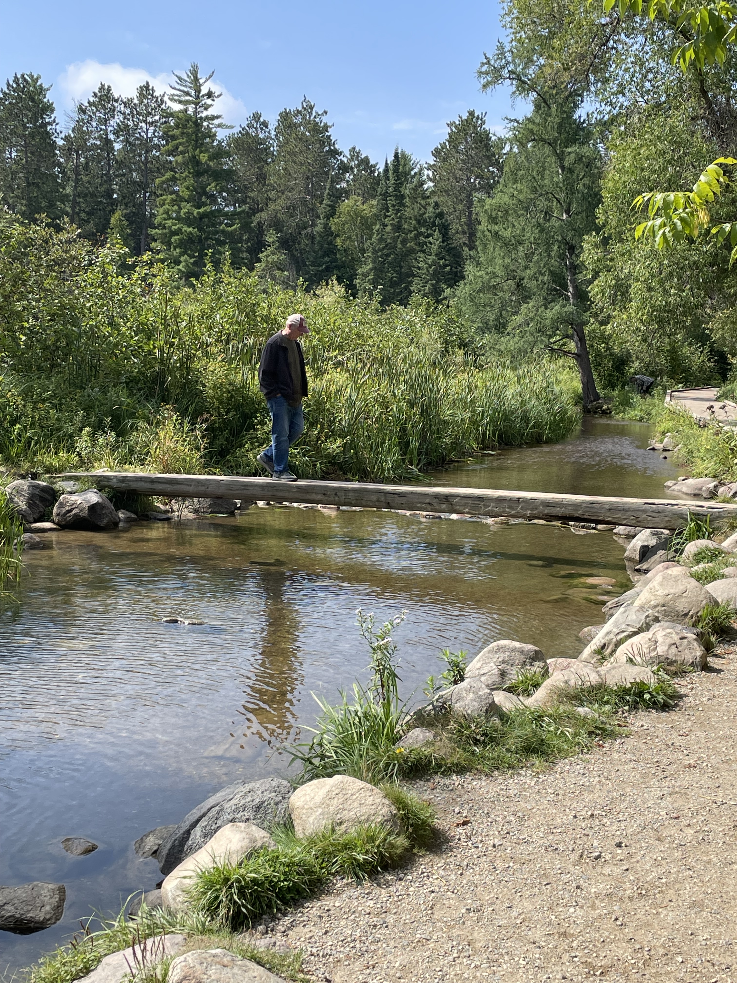
Saturday, August 26 we arrived at Itasca State Park, Minnesota. This is the shallow stream exiting the lake where Lake Itasca becomes the headwaters of the Mississippi River. Hard to imagine this little stream eventually drains 40% of the continental United States (all or part of 31 States).I walked across the Mississippi on a log.
The 1783 Treaty of Paris (signed by Benjamin Franklin, John Adams, etc.) included establishment of the Northwest Territories described as all the land east of the Mississippi River. As the river gets bigger and well defined that’s easy but at the northern end in Minnesota it was hardly clear but very important.
Not a National Park – so not an official NPS stamp – but in my mind a unique State Park with an interesting historical story. After one night at Itasca we went to nearby Bemidji KOA for two nights where we made last minute preparation to cross into Canada and meet up with John & Pam at Winnipeg West KOA. We did laundry and ate meals to use up things we couldn’t bring across the boarder like eggs, chicken, fruits, and vegetables.
Winnipeg West KOA bathrooms
Flowers outside the bathrooms
The land of Ketchup potato chips
Screen capture from my phone showing all the wildfires around where we were heading (Jasper and Banff National Parks are north and west of Calgary on the map). There were no fires directly in the areas we were going but they were all around.
Our motorhome and John & Pam’s travel trailer side-by-side at a rest stop.
River Valley RV Park in Langham, Saskatchewan. This was a really nice stop that we wished we could have stayed another day to enjoy. Beautifully well kept and clean. The only downside was the wildfire smoke was getting really thick so we stayed mostly inside.
Reddish sun seen through dense wildfire smoke.
Doing our part to reduce the Canadian insect population…
Rapeseed fields were abundant in Canada. A genetically modified version of this plant is where Canola oil comes from.
I was reading this book as we traveled. I am convinced this was Providential as it helped prepare my heart to receive news of Daniel’s death.
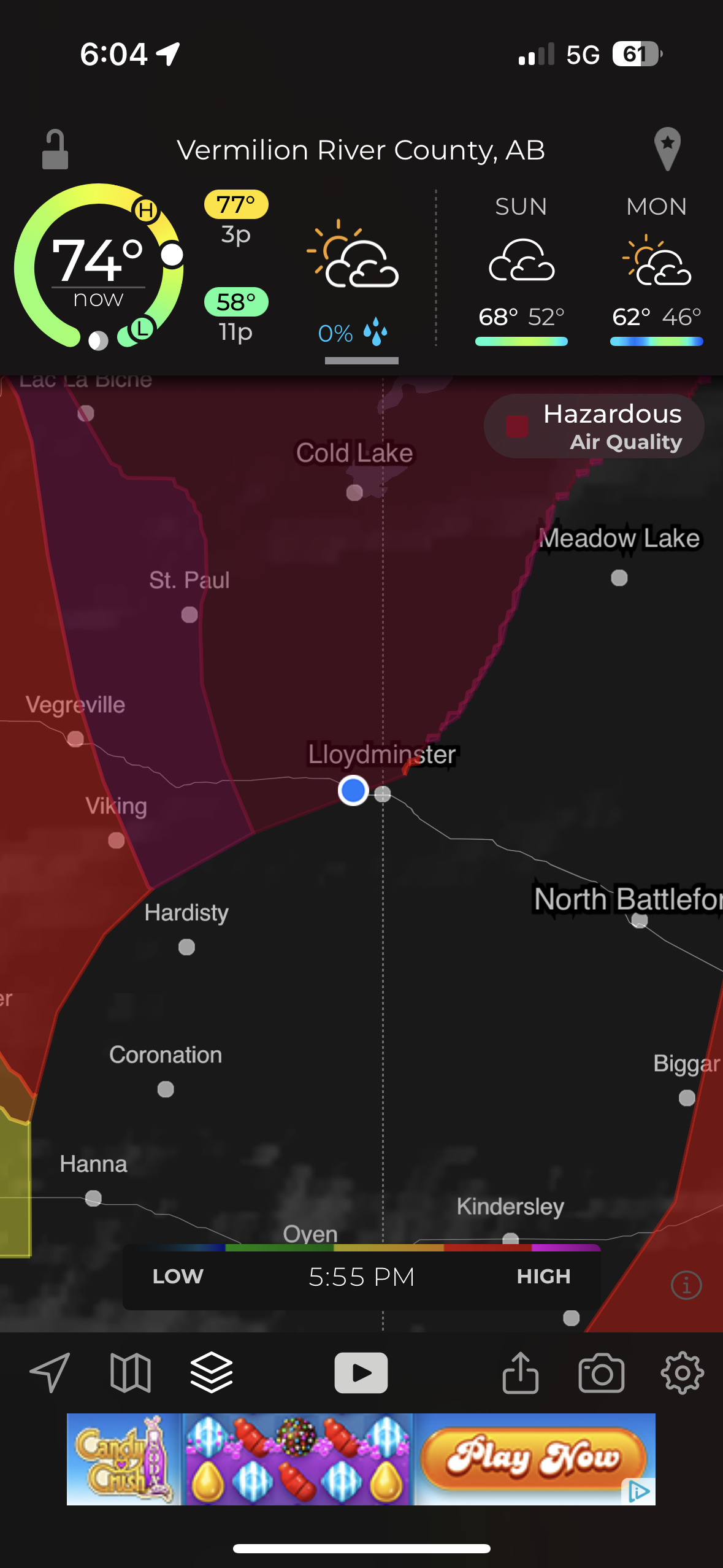
Our last stop before Hinton was “Camp N RV” in Lloydminster. This picture from my phone shows the worst air quality of “Hazardous” that we encountered.
Reddish smoky sky sunset as we arrived at Hinton KOA.
Part 2 – JASPER NATIONAL PARK
Jasper Day 1 – Old Fort Point and Five Lakes Hike
Becky was feeling better but wanted to wait one more day to be certain of not exposing John and Pam to covid. She stayed behind on this first day trip from Hinton KOA into Jasper National Park. The air was still smoky from wild fires but clearer then it had been on the trip into Hinton. The drive each day from Hinton into Jasper National Park (and back) took about an hour but each day the scenery was different and we almost always saw some beautiful sites and lots of wildlife.
The first drive into Jasper resulted in this beautiful bull elk standing majestically along the roadside.
Elk bull and cow showing off for the tourists.
The tourists all stop for the majestic wildlife. The locals get aggravated…
Mountain Goats
We saw Bighorn Sheep on the drive into Jasper. After stopping at the Visitors Center in Jasper and getting some advice on things to see and places to hike we started out to hike to an overlook called Old Fort Point (there was never a fort there).
Stairs at the beginning of hike up to Old Fort Point.
We hiked most of the way up and admired the smoky view of the Athabasca river valley and town of Jasper below. Pam and I were content to stop here but John needed to get to the top so he headed on up. When he came back down I met him and he asked “Where’s Pam?” Seeing she was not where she had been sitting and getting no response to calling out for her, John thought she might have headed up to find him. He hurried up looking for her and I headed down looking for her. Turned out she was just over the hill a little further down so after a bit of panic it all worked out. In that photo: nearly all of the trees in the valley and part of the town of Jasper were burned away in the wildfires summer of 2024.
This is looking up to the top of the overlook. I think that is John talking with a couple other people he met up there. The elevation gain from the bottom of the valley at the stairs to the top is 130 meters (426 feet).
John and Pam reunited and relieved. The next two pics (below) were from across the valley a few days later. They show the ‘hump’ where Pam and I stopped and the top of the overlook where John reached the peak.
Old Fort Point Overlook
Our next stop was the Valley of Five Lakes. We hiked the 9a/9b short loop.
John and Pam taking a break at one of Canada’s “Red Adirondack Chair” scenic locations.
Clear and beautiful lakes.
The lakes are still there but from what I read online the lakes are now muddy and the trees are all burned away after the summer of wildfires in 2024. Grateful to God that we were able to visit Jasper again before the fires.
We saw Bighorn Sheep on our drive back to Hinton.
Jasper Day 2 – Maligne Canyon and Maligne Lake
We were grateful that Becky was with us and the air was less smoky so we could enjoy the Beautiful Mountains and wildlife on the 2nd day.
Up close with Bighorn Sheep.
We really enjoyed Maligne Canyon. This is at the beginning of the canyon where the water is starting to carve down into the rock in smooth pools and eddies.
The next 4 photos show where swirling rocks and water have worn away smooth ‘pot holes’
The canyon hike is beautiful as the water cuts deeper down in waterfalls, sluices, and whirlpools. A series of bridges cross the river. Becky and I hiked to bridge #2 then turned around and returned to the van while John & Pam continued on to bridge #5 where we picked them up.
The name Maligne comes from the French word for ‘wicked’ or ‘evil’. While the English verb maligne is pronounced ‘muh-LINE’, the local Jasper pronunciation of the canyon’s name is ‘muh-LEEN’
Panorama shot stitched together from 10 photos.
View from the “5th Bridge” where we picked up John & Pam.
It had snowed on the mountaintops overnight which just increased the majesty of the surrounding peaks.
Maligne Lake. Becky and I enjoyed the gift shop and restaurant while John & Pam went for a hike.
A storm rolled in and rain started just as they got back from the hike.
Historic Boat House. The Boat House survived the fires of 2024 but much of the surrounding trees and infrastructure did not.
Not sure what bird this is in the bushes by the Boat House but the ‘birder’ lady that pointed it out to me seemed pretty excited about it.
John was driving and said “what else do you want to see?” I said “moose.” A little further down the road John pulls over and says “there you go”…
Mama Moose nursing Baby Moose.
Saw more Elk on the way back through Jasper while returning to Hinton KOA for the night.
King of the road
Jasper Day 3–Athabasca Falls and Sunwapta Falls
More snow during the night on the mountaintops
Saw more Elk along the road coming into the Park.
Athabasca Falls
Incredible amount of water pouring down the canyon.
Tourists
To be so close, to feel the rock foundations vibrate.
And we saw Bears. Up close, probably too close, but they seemed more interested in grazing on leafy greens.
Sunwapta Falls
Sunwapta Falls (means “Turbulent Waters”) is a series of cascading waterfalls.
Jasper Day 4 – Mt. Edith Cavell
The hike from the parking lot is long, steep, and beautiful. A stream follows the path part of the way. Eventually the trees become little short stunted pines above the tree line elevation.
Mount Edith Cavell (3,300 meters=10,800 feet) and Angel Glacier.
Mount Edith Cavell is named after a British nurse executed during World War I for her part in helping Allied prisoners escape occupied Brussels.
Photos below from our visit in summer 2016 compared to 2023.
August 23, 2016
September 7, 2023
Annual lines in glacial ice.
Below: John making careful rock selections (notice the distended pockets) and posing by high elevation pine tree.
John taking a moment to enjoy the mountain views
Stream of meltwater from Angel Glacier
Melting Angel Glacier Waterfalls
We stopped to see a mountainside with lots of bighorn sheep.
A Canadian military plane surprised us as it flew low through the valley on our return trip to Hinton.
Our campsite at Hinton KOA as we prepared to say goodbye to Hanson’s and head home.
Our last drive of the trip as we headed home was back through Jasper National Park and on down the Icefields Parkway, past the Athabasca Glacier, and Banff National Park.
A little post-trip travel analysis: This is all based on only our RV mileage (we traveled lots of other miles in Jasper NP with John & Pam in their van). 4,636 miles according to RVparky route, 4,691 actual miles. 436.25 gallons of gas. Cost – $1,761.77 for average cost/gal $4.04 10.75 miles/gal 22 nights/23 days total = average of 204 miles/day 13 different overnight places/14 days of traveling = 335 average miles per travel day Our longest Travel Days were the days coming home: 1st day: 638 miles from Hinton, British Columbia to Ponderosa Campground, Swift Current, Saskatchewan 2nd day: 362 miles to Old Settlers Park in Burlington, ND (includes border crossing) 3rd day: 623 miles to Stoney Creek RV Resort, Osseo, WI 4th day: 530 miles to Home = 2,153 miles home.
This is about our trip west for family gatherings in Kansas and Missouri, June 14 to June 30. It is also our first post composed entirely of iPhone photos. I had the big camera but never bothered to pull it out.
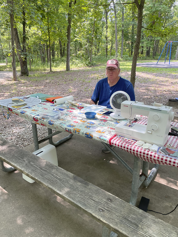
Our first camping spot on the way to the Kansas family gathering was Mark Twain State Park, MO. Becky was sewing quilt blocks and I was playing with watercolors. It was getting pretty warm out so we had fans going. I’m looking a little heat stroked…
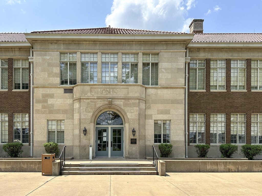
Entry to Monroe School in Topeka, Kansas. Brown v. Board of Education National Historic Site.
Got the passport stamp.
We stopped here on our way from Mark Twain State Park to the Kansas Family Gathering at Acorns Resort on Milford Lake in Kansas. On our many trips to Kansas over the last 40 years we have driven past Topeka and the signs for Brown v. Board of Education NHS. This is a thought provoking bit of historic preservation. Wish we had taken time to stop with the kids but we were always in a hurry to see family.
Becky checking out the information panel in front of Monroe Public School – Brown vs Board of Education National Historic Site. Monroe is the only remaining school of the four original buildings for black students in Topeka.
Plat drawing for Monroe School (on Monroe St). The schools for blacks and whites in Topeka were designed by the same Architect and while not exactly the same they were very similar in quality. Same windows, classroom sizes, finishes, etc. The issue in Topeka wasn’t regarding equal quality of educational facilities, it was equal access to education. The biggest issue (in Topeka) was that black students (even very young students like 3rd grader Linda Carol Brown) had to travel much longer distances, crossing busy streets and riding buses to get to one of the 4 black schools instead of attending a nearby school.
Brown v. Board of Education originated as a class action lawsuit in Topeka in 1951 and was ruled by the Kansas District Court in favor of the Board of Education. The case that later went to the Supreme Court was a combination of 5 different lawsuits (all of which had failed to the local Boards of Education). They were from Topeka-Kansas, South Carolina, Virginia, Delaware, and Washington DC. The combined case was brought to the Supreme Court by the NAACP. Thurgood Marshall at that time was chief counsel for the NAACP and argued the case for the plaintiffs. Thurgood Marshall would later be appointed to the Supreme Court in 1967.
South Carolina did have a quality issue… top photo is the one room shanty black school and below is the white students school. The photos make them look similar size so below is a photo of scale models of the buildings.
It is hard for me to wrap my head around some of the things happening around the time I was born… I know I’m old but I tend to think of stuff like this happening back in my grandparents day.
Monroe School from the parking lot looking across the playing field. The mural in photo below is to the right of where this was taken.
Mural on an adjacent building. Colorful, but so much going on it’s hard to tell what it all means.
Rainbow at Acorns Resort on Milford Lake. Jennie and Roni’s RV is the one on the left. Deanne’s and ours were just to the right out of this picture. We enjoyed three nights visiting and eating together. Wish we had taken a family photo with most everyone being there but didn’t think of it at the time.
Sunset at Milford Lake, Acorns Resort.
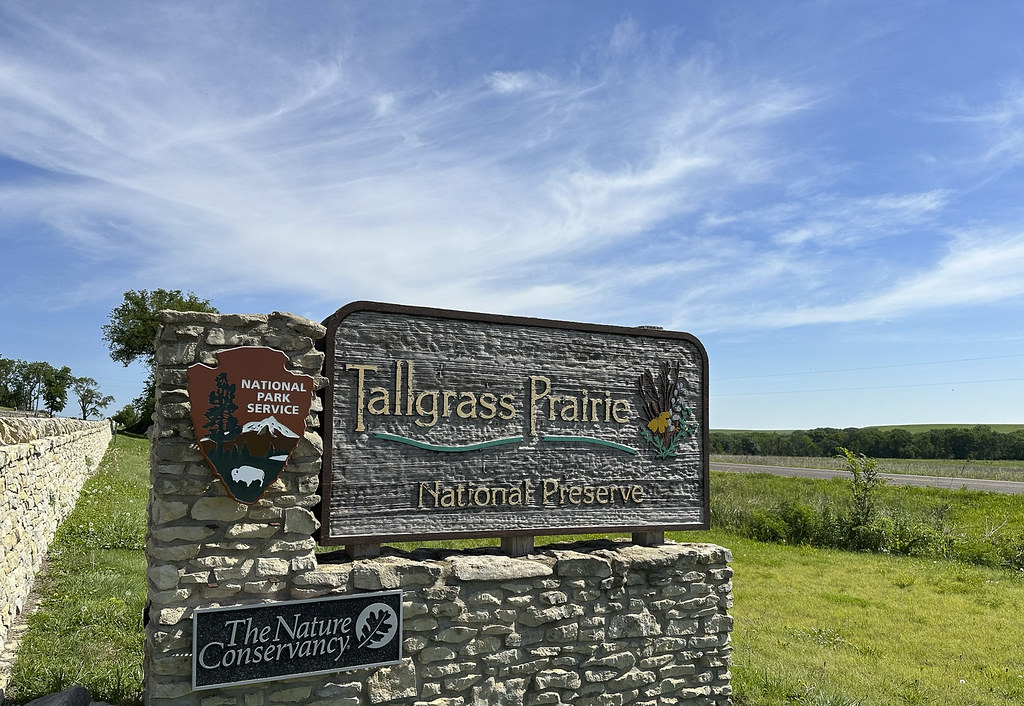
Traveling to our next stop we visited two places to get National Passport stamps. First stop was Tallgrass Prairie National Preserve near Strong City, KS. We visited the barn and the house but did not hike out to the prairie pasture where the bison roam (it was too hot).
Got the passport stamp and enjoyed the nice Visitors Center.
Beautiful stone fence and wide open Kansas Flint Hills.
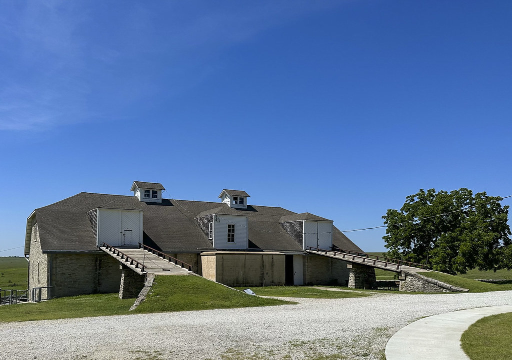
The property is known as the old Spring Hill Farm. The huge stone barn and impressive house still stand on the property but much of what is shown on this old lithograph is now back to prairie and pasture for a herd of Bison. The house cost $25K and the barn cost $15K to build back in 1880’s
The limestone barn. Wall at base are 20″ thick.
This view makes me feel better about the ramp into my yard barn…
The Chicken House with a sod roof. The backside is built into a hillside. The building kept the chickens cool in the summer and warm in the winter.
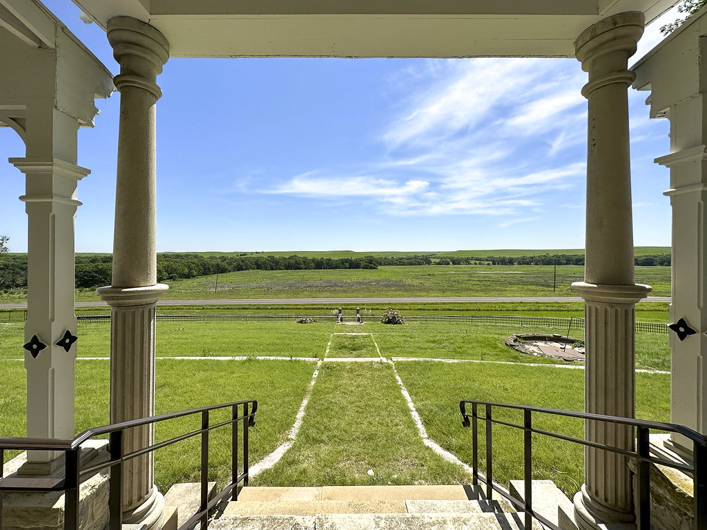
Approaching Spring Hill Farm House.
View from from the front entry steps of Spring Hill Farm House.
Crazy massive walnut newel post at bottom of entry stairway.
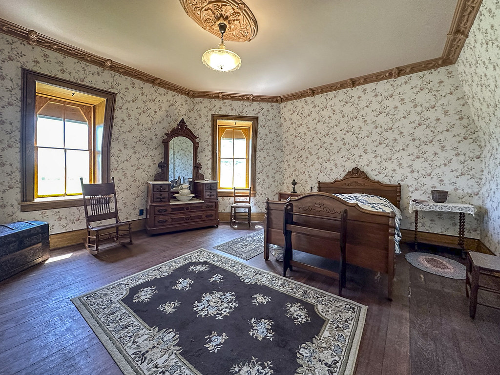
Bedroom at Spring Hill Farm.
One last photo of the amazing stone fence. From here we headed to Fort Scott.
We had been to Fort Scott previously and by the time we got there it was getting really hot so we just got the passport stamp. Advice for others – do not blindly trust your Garmin to lead you to the RV parking lot.
This is the only photo I took at Crawford State Park where we stayed for one night. I should have taken a video instead of a photo. All those white spots are a swarm of flying bugs (not mosquitoes fortunately). It was really hot and really buggy so we didn’t see much of the park but from our windows we watched the local fire department play with fire hoses on the Crawford Lake Dam.
Next stop was Roaring River State Park near Cassville, MO. We stayed here for three nights. Dale and Gwen (and their dogs KC and Mason) also came and stayed with us in their RV. Linda, Dan, and Charlene drove down to visit from Monett and took us to the nearby Roaring River Spring and Fish Hatchery.
Video of Rainbow Trout in the spring.
Lots of people fishing below the spring and hatchery created this unique bit of Missouri folk art of line and lure…
Brother Dan welcomed us with this puzzle he found at the very popular Monett “Bin Barn”. First puzzle I’ve completed in decades.
Gwen painted this cool watercolor of our RV from the vantage point of the picnic table at their site.
Watercolor dabble started at Mark Twain State Park and finished at Roaring River. Credit to brother Dale for motivating me to loosen up the pine tree that was more symmetrical until he described it as a “very happy little Bob Ross tree” after which I got sloppier with it and liked it much more. Thanks Dale!
Becky and Gwen played with various quilt block pattern ideas.
My first attempt (not finished) at landscape watercolor with expert guidance from Gwen Campbell (and editorial comment from Dale)
After Roaring River we headed to Monett for a few more days of visiting but discovered a front tire was wearing unevenly. With help from nephew Chris we made an early morning dash to Joplin to get an alignment and tires rotated.
We visited the new Monett Historical Museum and enjoyed their quality exhibits. Theodore Roosevelt made a “whistle stop” here in 1928.
1908 downtown Monett street scene.
Closeup of woman apparently astonished by meals for 25 cents at the “Indiana House”. Haven’t figured out what connection Monett, MO had with Indiana to warrant an establishment named “Indiana House” but I’m curious.
Terrifying 120volt apparatus for hair curling.
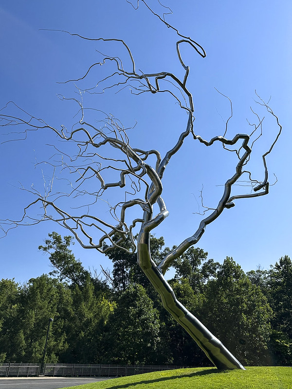
We visited “Crystal Bridges Museum of American Art” in Bentonville, Arkansas. This is a gleaming stainless steel tree sculpture near the entry. Bentonville is home of Walmart headquarters. The museum is free, envisioned, and funded by Walmart heiress Alice Walton, daughter of Sam Walton.
Beautifully landscaped grounds include sculptures like this giant spider.
Robert Indiana sculpture.
Dale Chihuly glass “snakes” sculpture.
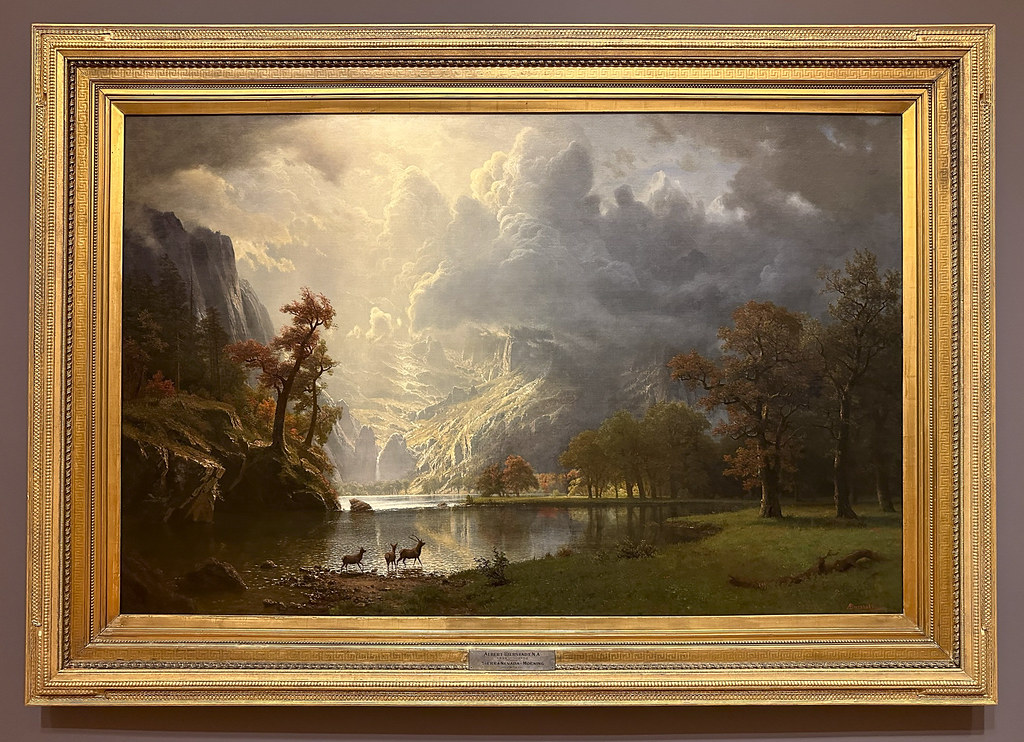
After walking the grounds we headed inside to escape the heat. This is a huge exhibit of Arkansas quartz crystals with Chihuly floating glass orbs and the “Great Hall” in background.
Interior of the “Great Hall” meeting space. I was more impressed with the Architecture, structure, and quality of construction than the art exhibits. The building housing the art exhibits is intentionally a work of art itself.
Albert Bierstadt 1870. Sierra Nevada-Morning.
George Inness. An Old Roadway ca. 1880. Seeing the original paintings and being able to get right up close to them was a real treat.
This Frank Lloyd Wright home was moved from it’s original site along the Millstone River in New Jersey to Crystal Bridges because of repeated flooding. Another example of the Art of Architecture being preserved and made accessible to the public at Crystal Bridges. Tickets are required to tour the house but they are free.
On our way to Crystal Bridges we stopped at Pea Ridge National Military Park to see the new Visitors Center and get the passport stamp (it was under construction on our last visit). On our way back to Monett, after Crystal Bridges, we drove the auto trail around the battlefield. The battlefield is 4,300 acres; it’s a long drive.
Once again we forgot to take a family photo with everyone gathered together in Monett. Leaving Monett to head home we stopped at Alley Spring. A picturesque mill powered by a beautiful blue water spring.
Alley Mill and water from the spring.
National Parks Passport Stamp for Ozark National Scenic Riverways from Alley Spring Visitors Center.
Continuing on through some very winding roads through the Ozarks we camped one night at Johnson’s Shut-Ins State Park near Middle Brook, MO. We had reservations for two nights but the next day was forecast to be over 100 degrees so we did a quick morning walk to the “Shut-Ins” then headed for home.
The “Shut-Ins” is an interesting geological area where the East Fork of the Black River narrows as it cuts though harder volcanic rock. We were there early in the morning but later in the heat of the day the pools of water are filled with bathers. The Black River is part of the Ozark National Scenic Riverways.
Interesting hole formations.
It had not rained in awhile so there was not much water flowing.
Driving through Illinois and southern Indiana we encountered dense Canadian wildfire smoke. Happy to be home after a long hot day of driving.
Wrap-up: 1,845 Miles total. 16 days. 10.11 MPG avg. $3.16/gal avg. $576 for gas. $130 for alignment and tire rotation in Joplin. We drove some really hot days with the RV (gasoline) generator running so we could run the house air conditioning and the engine AC. Running the generator seems to reduce MPG by about .3 MPG. We now have over 20,000 miles in the RV and will add another 6K this fall with trip to Canadian Rockies.
The New River Gorge National Park and Babcock State Park in West Virginia were our last stops of this trip.
Sandstone Falls on the New River (near the town of Hinton, WV)
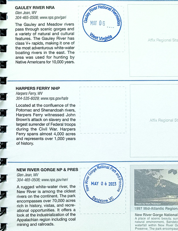
Our first stop was the Sandstone Visitors Center to get passport book stamps and to learn about the park. The National Park is mostly about the history of the New River and the Gorge, and the preservation of some of the old towns along the river.
Got stamps for both New River Gorge and Gauley River. We didn’t visit the Gauley River on this trip but Daniel, Nathan and I rafted the Gauley River with Songer Whitewater (years ago) so I felt like I’d earned the stamp. Someday we’ll need to visit Harpers Ferry to fill out this page.
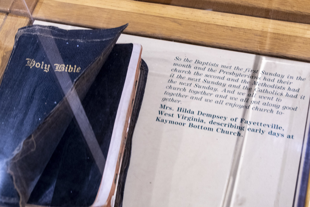
Baptists, Presbyterians, Methodists, and Catholics going to church together “…and we all got along good together and we all enjoyed church together.”
The area of the New River Watershed is huge. It begins at the very south end at a little spring near Blowing Rock, North Carolina. We had been at Blowing Rock while on the Blueridge Mountain Parkway several days before. From that little spring, water flows north and is joined by other rivers, including the Gauley, eventually joining the Ohio River, then the Mississippi; and finally ending up in the Gulf of Mexico. Interesting that one of our first stops on this trip was at Gulf State Park on the Gulf of Mexico and our last stop was here in West Virginia. It’s raining torrents at Babcock State Park now while I work on this post. This rainwater will wind up in the Gulf… which is a long way from here… I never would have guessed that long-distance relationship so stopping here helped me understand something more about how interconnected we are. The Little Buck Creek in our backyard in Indianapolis also winds up in the Ohio River so it mingles with water from that little spring at Blowing Rock, NC.
The park ranger said “no problem” to drive an RV to Sandstone Falls; “I’ve seen school buses down there”. The winding access road got narrower and narrower until it was just a single lane where we and oncoming traffic had to get well off the sides to get past each other. We made it, and it was worth the trouble.
There is a nice “boardwalk” for viewing the falls.
I thought it was just a short boardwalk out to an island with nice views of these falls.
Closeup of a small portion of Sandstone Falls
Then I realized the boardwalk kept going past the “minor falls” at the beginning to “the big falls” on the other side of the island at the end of the boardwalk.
Impressive Sandstone Falls on the New River
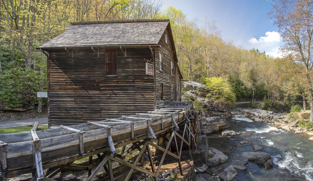
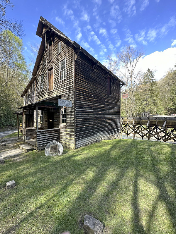
Glade Creek Grist Mill at Babcock State Park. Fully functional replica (built 1976) assembled from parts of three other mills. There were over 500 mills in West Virginia in early 1900’s. Read more about it here on the park’s website: https://wvstateparks.com/glade-creek-grist-mill-babcock/
Would like to come back to visit in the fall when it looks like this! Photo snip from website noted above. According to the website it is the most photographed mill in the US.
More pics of the mill. Getting these pics was providential. If we had known how small and tight the parking lot was we probably would not have taken the RV down to this mill. We just followed the sign that said entrance to Babcock State Park (which really meant just the entry to this mill and a bunch of cabins) and wiggled our way into a parking space. The campsites were at a different entrance further down the road. Alas, there were no signs telling us that…
Quintessential Appalachian mountain beauty.
Our nice private campsite overlooking a wooded ravine at Babcock State Park. We were happy to get to camp and relax after a day of driving mountain roads and navigating the mill parking lot.
Drifts of wildflowers at campsites looked like snow.
Wildflowers
I took a long exposure night photo with my phone while sitting outside at night. It turned out sort of watercolor-ish.
The next morning we visited the New River Gorge Bridge and Visitors Center as our last stop before heading home. It’s a beautiful structure. It’s intentionally not painted and meant to look rusty to minimize maintenance.
Completed in 1977, it was the tallest roadway bridge (876′ above the river) when it was built. It is still the third highest in the United States. It was also the world’s longest single span arch for 26 years. It is still the longest in the United States but there are four longer now in China.
This information plaque has a photo of the old bridge at the top which is still there but it was built down much closer to the river. The red line shows the crazy mountain road that took 45 minutes to navigate down the mountain and back up before the new bridge was built.
The gorge was a secluded area until lumbering, coal, and railroads changed all that.
Rapids on the New River.
One last selfie at New River Gorge Bridge Visitors Center looking down the gorge.
Kentucky has some big, yellow, bugs… they made a mess on the RV during the 400 mile drive home from New River Gorge, WV to Indianapolis, IN but it was good to be home.
We drove the Blue Ridge Parkway on two beautiful sunny days, May 3 from Asheville to Boone, NC and May 4 from Boone to Fancy Gap, Virginia.
May 3rd was sunny but with crazy winds. We met some people who where driving the parkway instead of visiting Biltmore because the Biltmore was closed due to high wind and danger of falling trees. Below is a video taken from the same overlook as the photo above.
Windy Video.
We went through lots of tunnels on the BRP. We were always driving when we came to the tunnels so I couldn’t get a picture but this is one that was coming up right after an overlook where I could get a pic.
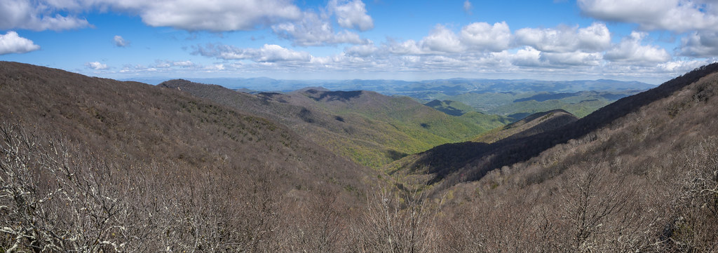
Panorama from Lane Pinnacle Overlook.
Grandfather mountain is part of the United Nations’ Southern Appalachian Biosphere Reserve. It is thought to be one of the oldest sections of the Appalachian Mountains. The mountain is estimated to be 300 million years old — with certain rock formations dating back 1.2 billion years.
Grandfather Mountain.
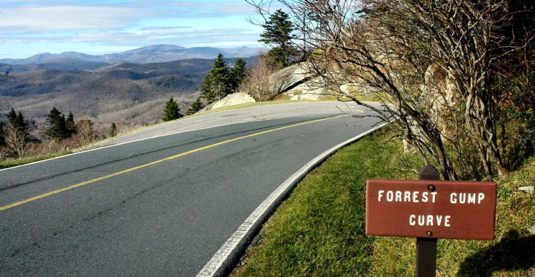
Trivia: This is not the Blue Ridge Parkway (and not my photo), but it must be noted (for history’s sake) that for 5 seconds in the Forrest Gump movie he is running around this curve of Grandfather Mountain.
Roadside Rocks and Rhododendrons.
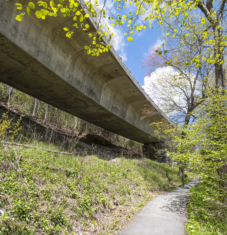
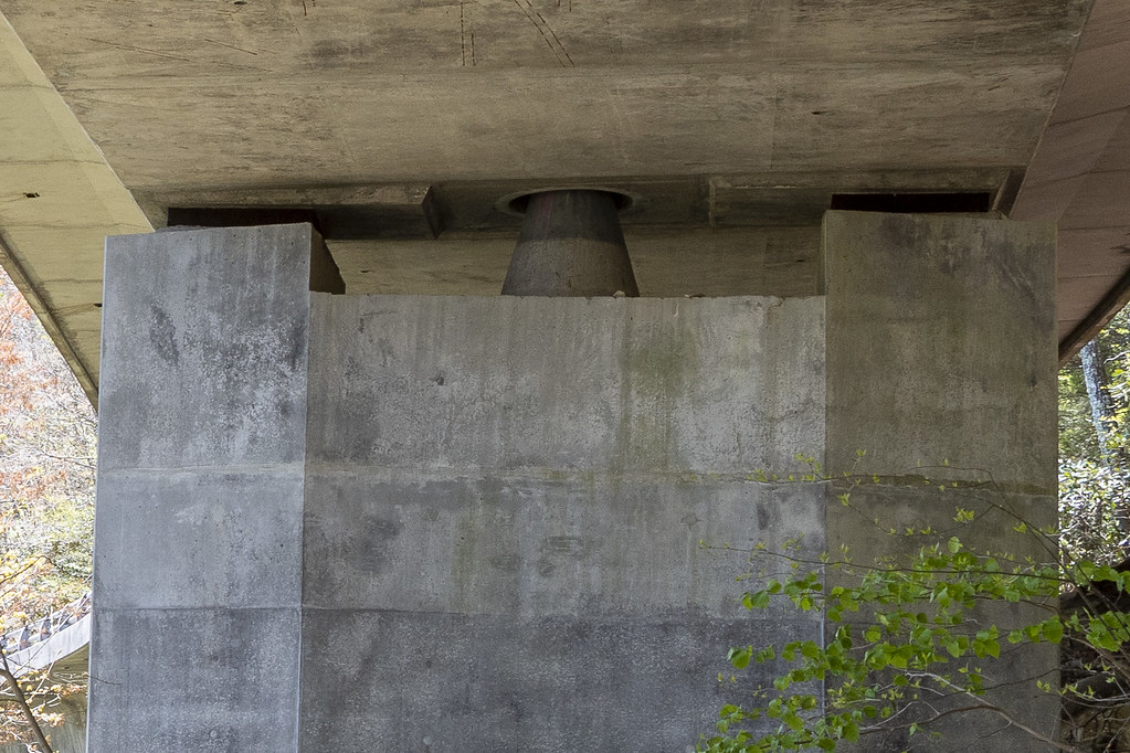
We went for a short walk to see the underside of the Linn Cove Viaduct. The 1,243′ long “S” shaped bridge follows around Grandfather Mountain at Linn Cove. At the time, it was considered the most complicated concrete bridge ever built. It is made of 153 curved segments that were precast individually nearby. Each segment weighs 50 tons. They are epoxied and cabled together and supported on seven piers. This last link in the Blue Ridge Parkway was completed with a ribbon cutting dedication 9/11/87. The Viaduct was built from the surface of the Viaduct itself, with minimal impact on the area below it (they did not build a road below it to build it from).
I know it’s nerdy but I thought it was interesting that the entire viaduct “balances” on the point of cones on the seven piers.
Closeup of Glassmine Falls. Back in the day they mined mica at the base of the falls (they called the shiny mica flakes “glass”).
Shocking isn’t it! That’s how we felt after coming off a day of driving the Parkway and hitting civilization again. While in Boone, we stopped for groceries and supplies at a Walmart. There was this huge stack of bright pink $89 Barbie Dream Campers piled in the middle of an aisle. It had to have been a sign… We’ve been wondering if our RV needs a name. Dream Camper comes to mind…
A Trio of Trilliums from our hike on Cascades Trail.
Video of the Cascades. Not impressive but a pleasant walk and beautiful surroundings.
Mountain Laurel has interesting stringy bark.
We met a nice couple from Toronto on our Cascades hike. Afterwards we saw them in the parking lot trying to take a selfie so we helped each other.
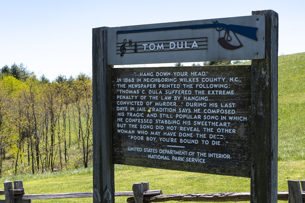
If you are old enough, you may know the song “Tom Dooley”. A folk song based on a 1866 murder of Laura Foster by Tom Dula (pronounced locally as Dooley). The song had been around for a long time but in 1958 the Kingston Trio version hit number one on the music charts. Tom Dula, a confederate soldier had just returned from the civil war which ended the year before. Here’s an interesting NPR article: https://www.npr.org/2000/07/31/1080167/npr-100-tom-dooley. Perhaps everyone having syphilis (Tom Dula and his three girlfriends: Laura Foster, Anne Melton, and Pauline Foster-Laura’s cousin) had something to do with it…
We did not see any bears but we did see deer several times on the Parkway. This is a quick iPhone shot.
We stopped for lunch and ate in the RV. This guy was hanging around trying to get in…
Thoughts on the Blue Ridge Parkway;
It’s a wonderful experience to drive for three days and never see a billboard, never see power poles and power lines, never see a semi-truck, never see a McDonald’s or any other of the ubiquitous stores that are seen at every intersection of an interstate. Each evening, when we got off the Parkway to camp, it was with a sense of loss, not comfort, to again encounter traffic, and traffic lights, and the cacophony of development stimulus we have become acclimated to.
The three driving days on the Parkway were similar in many ways but different in a few: 1. From Cherokee to Asheville, the scenery was very wooded and mountainous with lots of tunnels through the mountains and lots of steep uphill’s and downhills. Very few intersecting access roads and an awareness that there is nothing as far as the eye can see. 2. From Asheville to Boone, the scenery was less wooded, less tunnels, and a bit more gentle grades. More access roads and seeing towns and a few houses off in the mountains. 3. From Boone to Fancy Gap, the scenery is pastoral, with some open fields and gentle rolling pastures. Cattle and horses and passing some farms and towns within sight of the Parkway. I don’t remember any tunnels. Much more populated areas but still quite a secluded drive. They were beginning to start paving work on parts of this section. We encountered a closed portion and a long detour. After the detour and returning to the Parkway we waited for another section of single lane. By then it was getting late so we jumped off and took highways to Fancy Gap. 4. We enjoyed driving on the Parkway because there was almost no other traffic. We could look around, stop at any of the overlooks, and seldom saw other cars. The tunnels were not a problem. The only thing we needed to watch out for was overhanging branches but with no oncoming traffic it was easy to move over to miss them. I am sure it is a beautiful drive in the fall but I would not want to crawl along with lots of leaf peepers.
The entire BRP is 469 miles long. We drove 84 miles, from 469 at the southern end to 384 at the Asheville Visitors Center on the first day. 93 miles from 384 to Boone at 291 on the second day, and (most of) 92 miles from Boone to 199 at Fancy Gap on the third day. So we traveled (mostly) 270 miles on the Parkway (57% of the whole). Hopefully, someday, we can travel the northern end to Shenandoah National Park.
Tomorrow we leave the Blue Ridge Parkway and head north to West Virginia, New River Gorge National Park, and Babcock State Park.
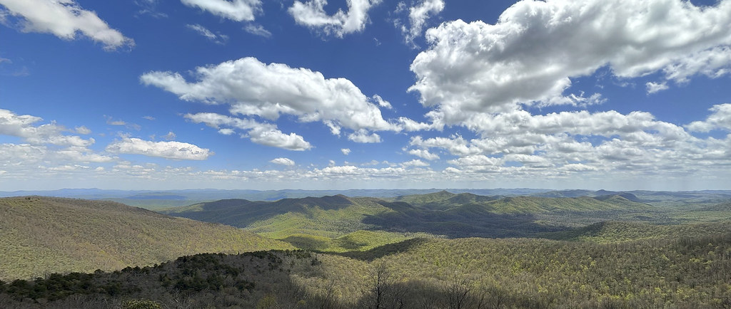
The beautiful Blue Ridge Mountains. A panoramic series of shots stitched together.
Before jumping onto the Blue Ridge Parkway we filled the RV up with gas. While I was doing that, Becky went into a little restaurant for coffee and donut holes. Highly recommend Mable’s Kitchen for breakfast. They don’t have donut holes on a shelf, you order them and they put them in the fryer. They are hot, fresh, and delicious.
Just getting started on the Blue Ridge Parkway (BRP). This sign at the Cherokee entrance.
Didn’t get very far and had to pull over on one of the many overlook parking areas. Very little traffic and plenty of space. We only went 84 miles but it took us all day because we stopped at so many of the overlooks.
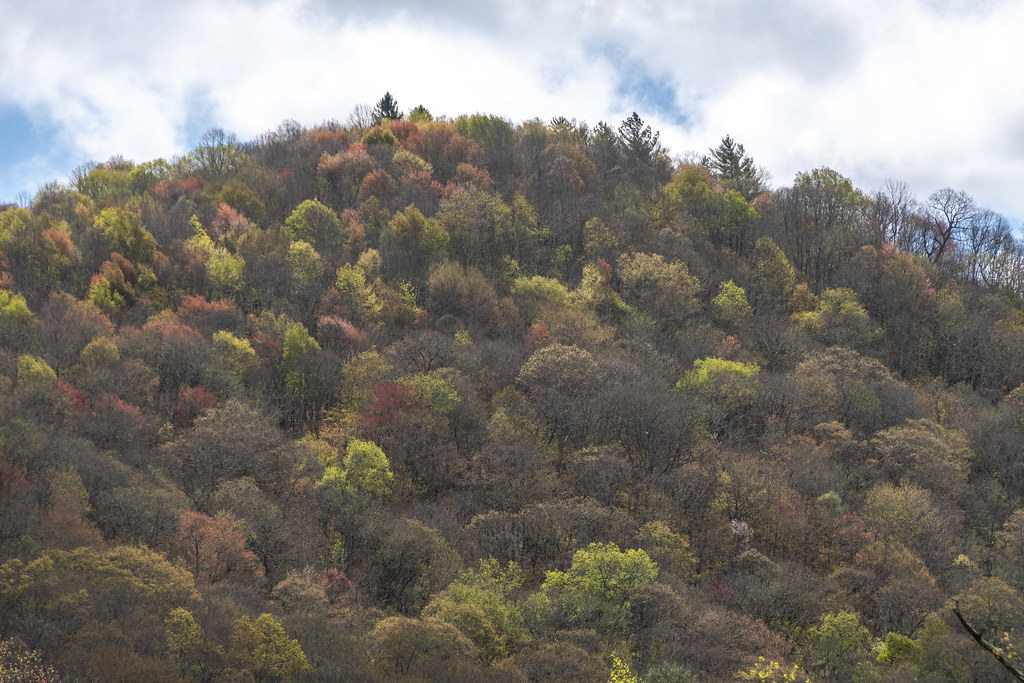
It being May 1st we were not expecting “fall colors,” but the “spring colors” were great!
Rhododendron were not flowering; but the Dogwoods were.
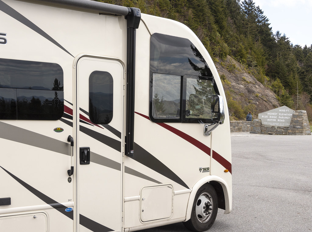
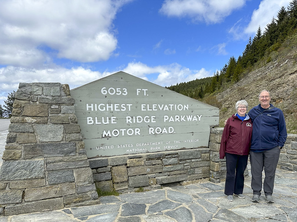
We (and the RV) made it to the highest point on the Blue Ridge Parkway at 6,053′.
It was a cool spring morning when we left Cherokee. The rocks along the parkway had little waterfalls of melting water. Up here the rocks were covered with sheets of ice and icicles. We didn’t see it snow but people at the Pisgah Inn where we had lunch said it snowed the night before.
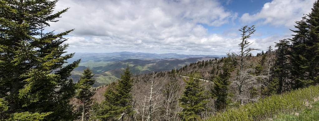
Panorama from “Bunches Bald” overlook.
The photo on the left is from “Waterrock Knob” Visitors Center when Becky and I visited 10 years ago in September 2013. Our plan then was to visit Smoky Mountain NP and drive the Blue Ridge Parkway… but, because of the fog, we got this far and decided to just come down out of the mountains and drive east to visit Kitty Hawk. The weather in 2023 was wonderful. The photo on the right is from the same place (Waterrock Knob Visitors Center) but looking a bit to the ‘left’ of the 2013 photo.
Waterrock Knob looking to the right.
Panoramic view from the observation deck at Pisgah Inn.
There is a nice restaurant at Pisgah Inn. We enjoyed lunch and the beautiful view out the big restaurant windows. Someone offered to take our pic. If we look a little frazzled there is a reason. The parkway is a two lane road with no curbs on the edge and almost no guardrails. It was really windy. As we rounded a bend there was a tree fallen across both lanes and well beyond. The tree had just fallen and a few cars were driving down a grassy ditch, out around the tree, and back down and up to the road through the ditch on the other side. There was no place to turn an RV around and cars were starting to stack up on both sides of the fallen tree. Not knowing if we would sink into the grass or bottom-out in the ditch we went for it. Rolling back and forth like a drunken sailor we made it around. Praise the Lord. That was not the Blue Ridge Parkway experience we expected… We will be getting a dash camera so we have proof next time we go off-roading in a 12,500lb RV.
Last panorama from the BRP on our first day. So grateful that the generations before us decided it would be a good idea to use taxpayer dollars to build a parkway through the mountains and to protect a large portion of the mountains from development so we can all enjoy these views.
We stayed at the Asheville East KOA for the night then visited the Ashville BRP Visitors Center and the Folk Art Center the next day.
Quote on the wall entering the Visitors Center. Vision Statement for the Parkway.
Entry to Asheville Blue Ridge Parkway Visitors Center
Interior of the Ashville Blue Ridge Parkway Visitors Center.
Examples of wood work done with Chestnut Tree wood. Most chestnut trees were wiped out by blight.
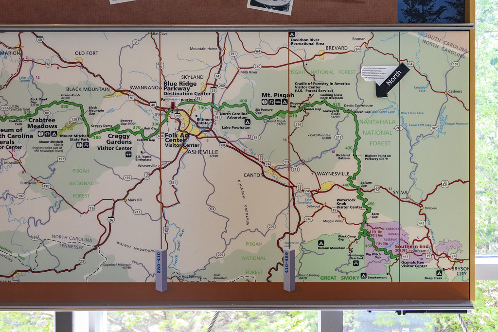
The green line is the BRP. The small portion we drove on May 1st is from Cherokee (at bottom right) to Ashville (basically where it says Folk Art Center a little left of center on the map).
The entire 469 mile long Blue Ridge Parkway from Shenandoah National Park to Smoky Mountain National Park. We drove a little over 1/2 of the length in 3 days of about 90 miles a day.
Couldn’t resist a pic of this pic. Not sure if the guy in boots and stubby tie is an Engineer or a Landscape Architect. Whoever he is it looks like he’s trying to impress the photographer. I am impressed by the stone masons building the nearly flat arch in the background!
Another pic of a pic. We will be driving on this Linn Cove Viaduct tomorrow (but without the fall colors or the helicopter view).
This orange flowering azalea is the only photo I have from the Folk Art Center. No photography is allowed. There were so many things I wanted to take photos of to remember! Alas, they would prefer we purchase them but that would require winning the lottery.
The Folk Art Center is incredible. It is home to the Southern Highland Craft Guild. The woodworking, quilting, textiles, carving, wheat weaving, pottery, etc., etc. is mind-blowing, beautiful, best-of-the-best stuff. This is a “must visit” place. I was thinking that visiting Biltmore was the most impressive thing to do in Asheville. The Folk Art Center may top that.
We camped at Cherokee KOA after a long drive, made longer by our stop at Ninety Six National Historical Site. It was fun leaving the flat coastal areas we had been visiting for three weeks and heading inland to start our next goal of; “Drive the Blue Ridge Parkway”.
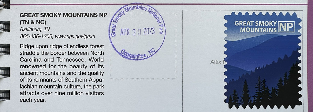
Got the stamp at GSMNP Oconaluftee Visitors Center. This is the Eastern entrance to GSMNP just outside of the town of Cherokee, NC.
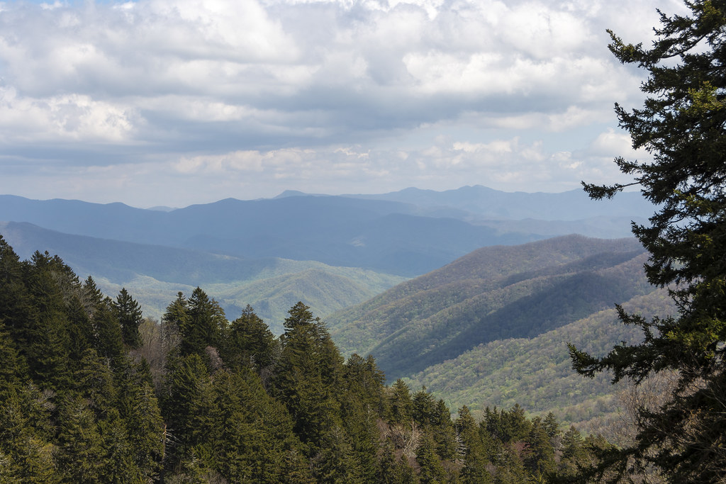
We stayed in Cherokee because the Blue Ridge Parkway ends (or in our case, starts) in Cherokee as the Southern terminus of the BRP. We had a day to rest before starting the BRP so we drove into GSMNP. The RV did great motoring up to the top of Newfound Gap and the views were wonderful out the big front windshield.
View of clouds on the mountain from our campsite this morning. Reminded me of Smoky Mountain backpacking adventures in younger days.
View from the Oconaluftee Visitors Center.
There was a chicken wandering around loose at the Visitors Center. I stopped worrying about bears.
We made it to the top at Newfound Gap. That’s our Axis RV in the parking lot. The only RV in the parking lot, hmmmm…
Admission to GSMNP is free but there is now a ‘parking fee’ if you are going to stop and park anywhere in the park longer than 15 minutes.
The Appalachian Trail (AT) mostly follows a mountain ridge inside of GSMNP. Here at Newfound Gap the trail crosses the road and picks up again on the edge of the parking lot. Only 1,972 miles to the Northern end of the trail at Mount Katahdin in central Maine.
Views from Newfound Gap
At the bottom of Newfound Gap Road, near Cherokee, the road follows along the Oconaluftee River. The water is so clear!
This area of the woods was full of white flowers blooming
Ending this post with a bunch of beautiful butterflies. There were a bunch of bees too so I didn’t stay long. Someone had spilled something sugary on the pavement-not very natural but the butterflies were cool… (maybe pipevine swallowtails?)
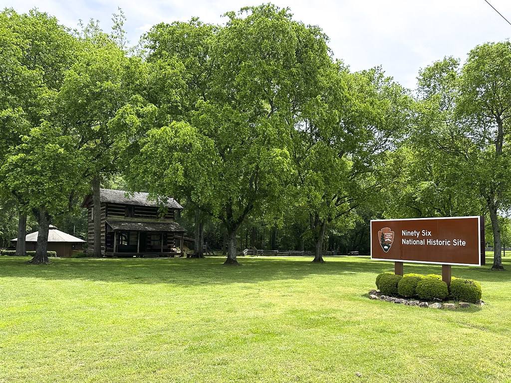
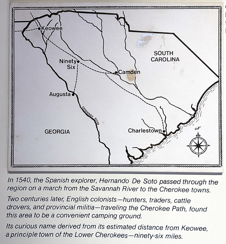
Ninety Six is a town. We had no idea what we would find here but it was a place to get a passport stamp and it was along the route we were taking from Santee to Cherokee.
Got the stamp and read some interesting history but because we still had a long way to go (and there were bugs and bees) we didn’t do the hike back to the fort. Glad we stopped. Interesting to learn more about “the South” on this trip.
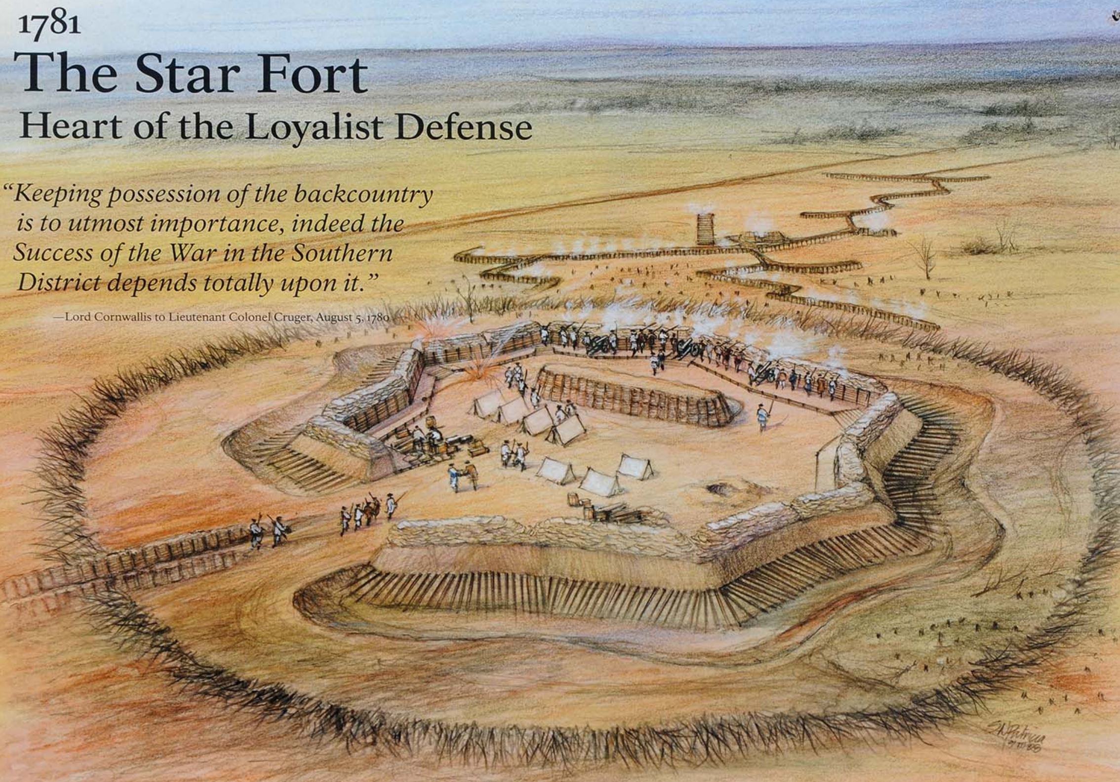
Artists rendering of the fort from the internet. It was a British fort, built by slaves, and defended by British loyalists against patriots in the first land battle south of New England.
The hike we could have taken, but didn’t…
That’s it for Ninety Six. Wish our historian friend Steve Elder had been with us! He would have enjoyed this stop. I feel like I should have at least heard of this town somewhere in my history schooling. Maybe I did but forgot. History was not very interesting back then…
Trivia: The nearby town of Greenwood, SC is the home of Park Seed Company. The largest mail-order seed company in the world.