Alaskan Adventure: Days 76-79. An incredible city, with an incredible history.
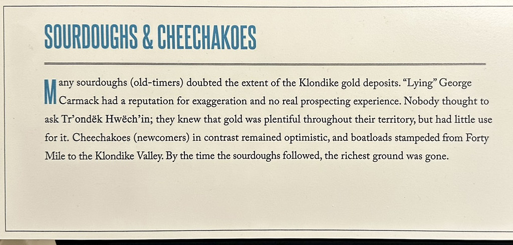
Before the Klondike Gold Rush began in August 1896, Dawson City did not exist as a town; the site along the Yukon River, at the confluence of the Klondike River, was primarily a seasonal salmon-drying and fishing camp used by the Indigenous Trʼondëk Hwëchʼin First Nation (full time population-zero). By winter of that same year, about 500 gold seekers were settling into the town that Prospector Joe Ladue and merchant Arthur Harper staked out on the river mudflats. For the next 2 years the fledgling city would explode to 17,000 people at it’s height.
Below is a 1901 picture of a Hotel, Photography Studio, and Hardware store on 3rd Avenue. The photo below that is their condition today. Built on frozen ground (permafrost) the footings have settled down into the old mucky river mud.


The 3rd Avenue Hotel, Photography Studio, and Hardware Store today.


Other old buildings around town.


The old Post Office has been completely rebuilt and is beautiful inside.


Saint Andrews is still standing but just barely. Sad to see these historic places crumbling but at the same time it gives visitors a chance to feel the history of this place.


Saint Andrews today.


The streets throughout Dawson City remain dirt (and mud the morning we first visited was rainy), but much of the wooden sidewalks are replaced and many buildings are new or restored to fit the character of Old Dawson City.
The scar on the mountainside seen on the photos above and below is a landmark feature of Dawson City. It is at the north end of the city which is also where the ferry operates so it is very prominent while waiting to cross the river and at the landing on the Dawson City side. The locals call it “Moosehide Slide”. It is known as Ëdhä Dädhëcha by the local Tr’ondëk Hwëch’in First Nation, meaning “Weathered Moosehide Hanging”.
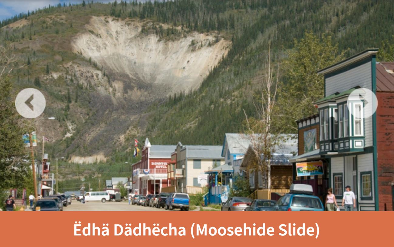
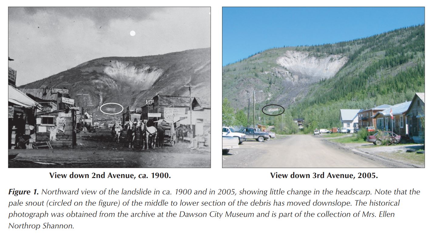
Interesting photos about 100 years apart of the landslide. Also interesting that in 1900 ALL the trees had been cut down for the town, the sternwheeler ships, and fuel for winter heating.
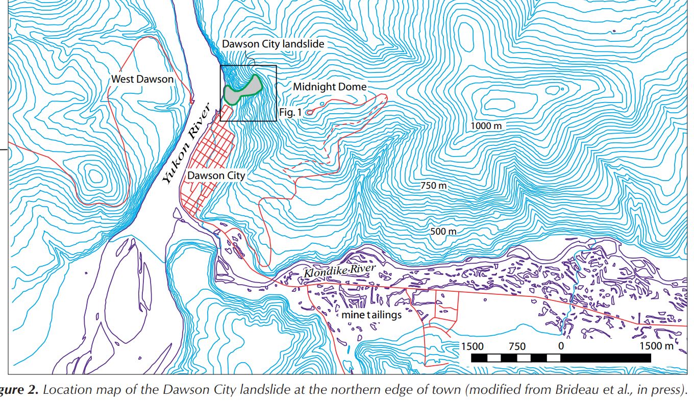
Red line on the West Dawson side of the Yukon River is the Top of the World Highway ending at the ferry landing on the west side. The Klondike River originally ran on the south side of the valley. Gold dredge mining and mine tailings moved the river to the north side of the valley. The two screenshots above were found at this website: https://emrlibrary.gov.yk.ca/ygs/yeg/2006/2006_p123-138.pdf

Dawson City illustration 1903, before dike along the river and before gold dredges in the Klondike River Valley.
Since 1898 there have been 22 recorded floods of Dawson City. The floods typically occur in the spring with high meltwater during ice breakup. 1979 was one of the worst. The city tried but failed to keep the water out with a sandbag dike along the Yukon and Klondike rivers. Following that flood a permanent 2 meter high dike was built along the river. The top of the dike is a walking path.

Inside the Red Feather Saloon

Old photo of the Red Feather Saloon.

Inside the British North America Bank.
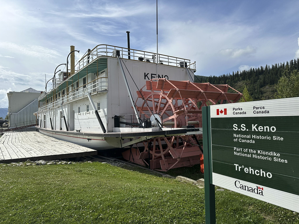

It’s hard to tell in the photos but the S.S. Keno is placed on top of the dike between the Yukon River and Front Street.

This Sternwheeler was built in Whitehorse in 1922. It was primarily used to haul silver-lead concentrate and had only a 2′ deep draft to navigate shallow rivers. It was retired in 1951.


We learned that the reason the ferry was so busy on the Friday we arrived was because of people arriving to participate in the Dawson City Annual Discovery Day Parade and other festivities.

Robert Service lived and wrote much of his prose (he did not want it called poetry) in Dawson City. We visited his cabin which still remains.


Robert Service cabin.


Inside the cabin.

View looking down into Dawson City from the uppermost street on the mountainside. The Robert Service cabin is up on that street.


The old cemetery, with wooden headstones, is also up on the mountainside street.

A Dawson City tragedy in 1918. The Lynn Canal is a natural glacially carved fjord (not a manmade canal). It is over 2,000 feet deep; the deepest in North America except for Greenland. Becky and I were on a cruise ship to Juneau in 2018 and on a tour boat just weeks ago when we sailed from Haines to Juneau and back on the Lynn Canal…


Dawson City Museum had lots of info on gold rush days and early days in Dawson City.


Interesting food choices.

Shave and a haircut, two bits…

Jack London’s Cabin. We visited the Jack London Museum.

Inside one half of Jack London’s cabin. The other half of the cabin is in Jack London Square in Oakland, California. London had carved “Jack London, miner author, Jan. 27, 1898” into the back wall logs of his cabin in 1898. There is a fascinating story about this cabin that you can read about here: https://jacklondonmuseum.ca/wp-content/uploads/2016/12/Jack-London-Cabin-updated-Dec-5-ks.pdf


List of books by Jack London and some local history on his famous “Call of the Wild” book and the dog “Buck”.

Historic incident that inspired the Jack London book “The Unexpected”

Another historic incident that was included in Jack London’s boo “The League of Old Men”


Couple of paintings I liked at the Jack London Museum. They are both of his cabin and food cache.


We ate dinner with Mike and Amy at Sourdough Joe’s. The fish was delicious and we somehow didn’t get rained on.


Sourdough Joe’s menu has interesting early days history of Dawson City. Here’s a link to a Park’s Canada website with lots of early history of the early gold rush days: http://parkscanadahistory.com/series/chs/26/chs26-1g.htm
Individual miners quickly exhausted the surface gold. In only a few years their individual claims were bought up by large corporations. The corporations funded huge dredging machines that could only be profitable with large tracts of land processing tons of gold bearing gravel.

Model of a gold dredge in the Dawson City Visitors Center

The real thing. We toured Historic Gold Dredge No.4; the largest wooden-hulled bucket-line gold dredge in North America.


Our tour guide describing how the dredge worked and some of the steel pieces used to “stratify” or separate the gold from the gravel the dredge brought up. The fiber mat is the last step. The heavy gold would settle into the mat and be collected from there.

Buckets of Gold


Huge direct current electric motors drove all the machinery.


Huge gears made intense screeching and grinding noise. No grease or oil was used because gold is strongly attracted to grease and oil. Gold flakes coated in oil would float or attach to bubbles and not settle by gravity to be captured. The noise from the gravel and metal working through the dredge could be heard constantly from miles away. Most dredge workers were deaf or very nearly deaf.

View looking into the “trommel”. One of the last stages of gravel/gold separation. The gravel that was dredged up has already been washed and the big rocks removed. The wet washdown gravel and sand was fed into this trommel which had water being sprayed into it by the pipe in the center. The heavy gold bits washed down out of the trommel while the rocks got fed out the back of the dredge.
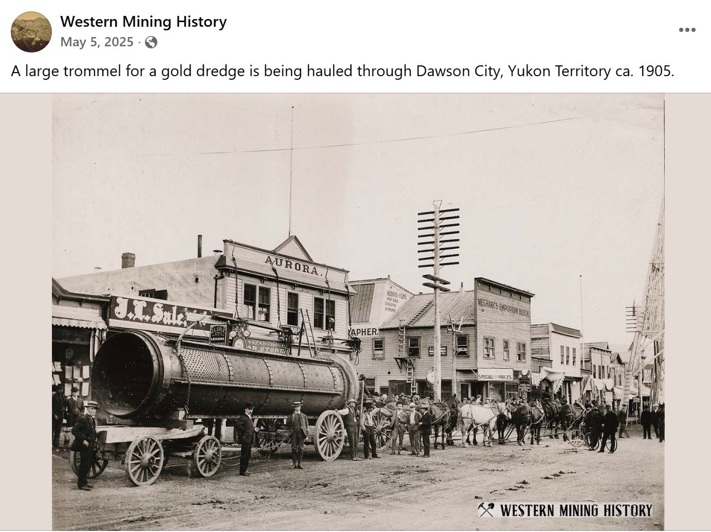
A better view of a gold trommel in Dawson City


This is the “front” end of the dredge, where the chain of buckets dig down to the bedrock where gold has settled. The “Control Room” with rows of levers control the movements of the dredge. The Control Room is the only place on the dredge with heat. The dredges ran continuously 24/7. Only stopping to clean out the gold from the fiber mats.

Our RV tour included a trip to “Diamond Tooth Gerties Gambling Hall”. Canada’s oldest licensed gambling hall. Gertie was a real historical person from gold rush days with a diamond mounted between her front teeth.


Wintertime mural painting of miners crossing a mountain pass and Dea (blue t-shirt and pants) from our group on stage with the cancan girls.

Mike and Amy drove us up the “Dome Road” in their truck, to the “Midnight Dome Viewpoint”. The viewpoint overlooks the Yukon River, Dawson City, and the Klondike River Valley which flows into the Yukon from the left in this view.

Tourists

A view that includes more of the Klondike River Valley extending to the left. It is hard to appreciate how much gold mining, especially gold dredging, has destroyed the valleys. The “Gold Dredge No. 4 Historic Site” is up the valley on the far left of photo.

Photo zoomed in from the Midnight Dome Viewpoint. Mounds of gravel dredge tailings in what was the Klondike River Valley in the foreground. The washout from dredging operations up the Bonanza Creek Valley in upper left.

This is a screenshot from Google Maps of the Klondike Valley leading into the Yukon River at Dawson City. The serpentine mounds of gravel left from dredging operations cover the valley. The tour guide described dredging as “turning the valley upside down”. Most of the gold settles as far down as it can go which is at the bottom of all the sand and gravel of the creek/river. The goal of the big dredge buckets was to go down to “bedrock”. The buckets teeth were replaced frequently as they gouged out the bedrock to get the gold that had settled down there.

View at sunset looking the other direction on Midnight Dome Viewpoint was beautiful.
Favorite Bible verse of the day: Hebrews 11:3
“By faith we understand that the worlds were prepared by the word of God, so that what is seen was not made out of things which are visible.”

