Blue Ridge Parkway: Asheville, NC to Fancy Gap, VA

12 of 13 Jekyll Island Trip Series.

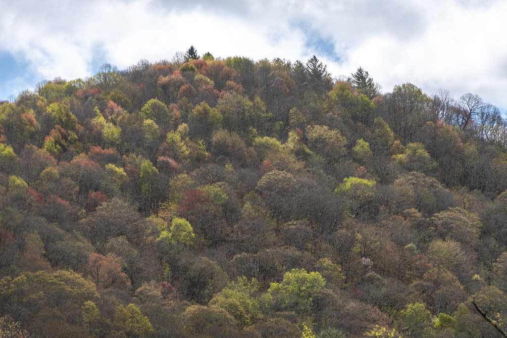
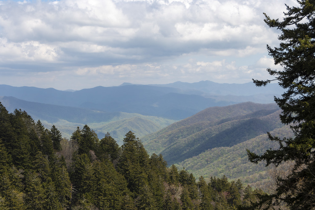
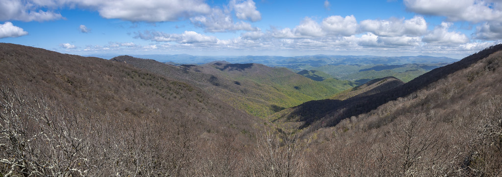
We drove the Blue Ridge Parkway on two beautiful sunny days, May 3 from Asheville to Boone, NC and May 4 from Boone to Fancy Gap, Virginia.

Blue Ridge Parkway3_UNTITLED_PANORAMA-1
May 3rd was sunny but with crazy winds. We met some people who where driving the parkway instead of visiting Biltmore because the Biltmore was closed due to high wind and danger of falling trees. Below is a video taken from the same overlook as the photo above.

Windy Video.

Blue Ridge Parkway3__DAD6955
We went through lots of tunnels on the BRP. We were always driving when we came to the tunnels so I couldn’t get a picture but this is one that was coming up right after an overlook where I could get a pic.
Blue Ridge Parkway3_LANE PINNACLE_PANORAMA-1
Panorama from Lane Pinnacle Overlook.
Blue Ridge Parkway3__DAD6975
Grandfather mountain is part of the United Nations’ Southern Appalachian Biosphere Reserve. It is thought to be one of the oldest sections of the Appalachian Mountains. The mountain is estimated to be 300 million years old — with certain rock formations dating back 1.2 billion years.
Blue Ridge Parkway4_GRANDFATHER MOUNTAIN_PANORAMA-1
Grandfather Mountain.

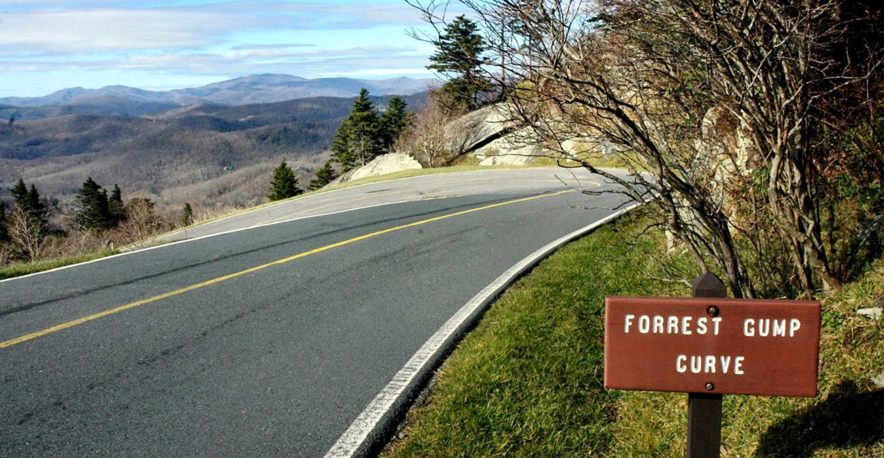
Trivia: This is not the Blue Ridge Parkway (and not my photo), but it must be noted (for history’s sake) that for 5 seconds in the Forrest Gump movie he is running around this curve of Grandfather Mountain.

Blue Ridge Parkway3_ROADSIDE ROCK_PANORAMA-1
Roadside Rocks and Rhododendrons.
Blue Ridge Parkway3_LINVILLE VIADUCT_PANORAMA-1
We went for a short walk to see the underside of the Linn Cove Viaduct. The 1,243′ long “S” shaped bridge follows around Grandfather Mountain at Linn Cove. At the time, it was considered the most complicated concrete bridge ever built. It is made of 153 curved segments that were precast individually nearby. Each segment weighs 50 tons. They are epoxied and cabled together and supported on seven piers. This last link in the Blue Ridge Parkway was completed with a ribbon cutting dedication 9/11/87. The Viaduct was built from the surface of the Viaduct itself, with minimal impact on the area below it (they did not build a road below it to build it from).
Blue Ridge Parkway3__DAD6996
Blue Ridge Parkway4Piers__DAD6997
Blue Ridge Parkway4Piers__DAD6998

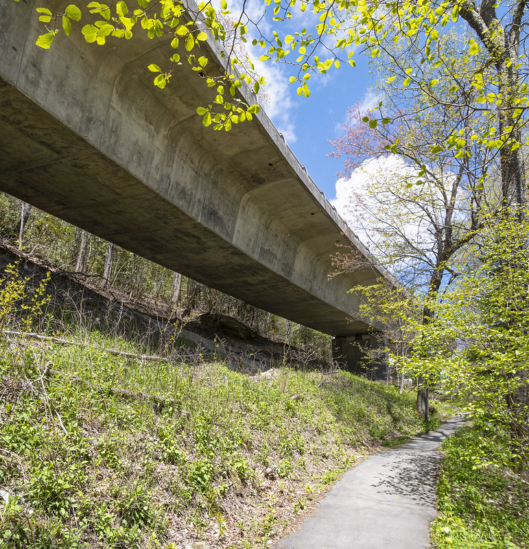
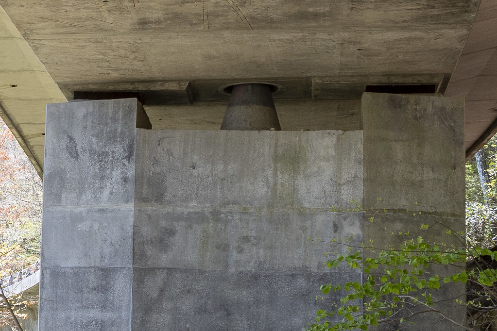
I know it’s nerdy but I thought it was interesting that the entire viaduct “balances” on the point of cones on the seven piers.

Here’s a link to more info on the Linn Cove Viaduct from NPS: https://www.nps.gov/blri/learn/historyculture/linn-cove-viaduct.htm#:~:text=The%20viaduct%20was%20constructed%20from,heavy%20equipment%20on%20the%20ground.

Blue Ridge Parkway3__DAD6963
Blue Ridge Parkway3__DAD6956
Blue Ridge Parkway3__DAD6960
Closeup of Glassmine Falls. Back in the day they mined mica at the base of the falls (they called the shiny mica flakes “glass”).
Blue Ridge Parkway3_IMG_3347
Shocking isn’t it! That’s how we felt after coming off a day of driving the Parkway and hitting civilization again. While in Boone, we stopped for groceries and supplies at a Walmart. There was this huge stack of bright pink $89 Barbie Dream Campers piled in the middle of an aisle. It had to have been a sign… We’ve been wondering if our RV needs a name. Dream Camper comes to mind…
Blue Ridge Parkway3__DAD7009
Blue Ridge Parkway3__DAD7002
Blue Ridge Parkway3__DAD6989

A Trio of Trilliums from our hike on Cascades Trail.

Blue Ridge Parkway3__DAD7042
Blue Ridge Parkway3__DAD7041
Blue Ridge Parkway3__DAD7036
Video of the Cascades. Not impressive but a pleasant walk and beautiful surroundings.
Blue Ridge Parkway3__DAD7029
Blue Ridge Parkway3__DAD7033
Blue Ridge Parkway3__DAD7030

Mountain Laurel has interesting stringy bark.

Blue Ridge Parkway3_IMG_3352
We met a nice couple from Toronto on our Cascades hike. Afterwards we saw them in the parking lot trying to take a selfie so we helped each other.
Blue Ridge Parkway3__DAD7045
Blue Ridge Parkway3__DAD7044
If you are old enough, you may know the song “Tom Dooley”. A folk song based on a 1866 murder of Laura Foster by Tom Dula (pronounced locally as Dooley). The song had been around for a long time but in 1958 the Kingston Trio version hit number one on the music charts. Tom Dula, a confederate soldier had just returned from the civil war which ended the year before. Here’s an interesting NPR article: https://www.npr.org/2000/07/31/1080167/npr-100-tom-dooley. Perhaps everyone having syphilis (Tom Dula and his three girlfriends: Laura Foster, Anne Melton, and Pauline Foster-Laura’s cousin) had something to do with it…
Blue Ridge Parkway3_IMG_3345
We did not see any bears but we did see deer several times on the Parkway. This is a quick iPhone shot.
Blue Ridge Parkway3_IMG_3356
We stopped for lunch and ate in the RV. This guy was hanging around trying to get in…
Blue Ridge Parkway3__DAD7046

Thoughts on the Blue Ridge Parkway;

It’s a wonderful experience to drive for three days and never see a billboard, never see power poles and power lines, never see a semi-truck, never see a McDonald’s or any other of the ubiquitous stores that are seen at every intersection of an interstate. Each evening, when we got off the Parkway to camp, it was with a sense of loss, not comfort, to again encounter traffic, and traffic lights, and the cacophony of development stimulus we have become acclimated to.

The three driving days on the Parkway were similar in many ways but different in a few:
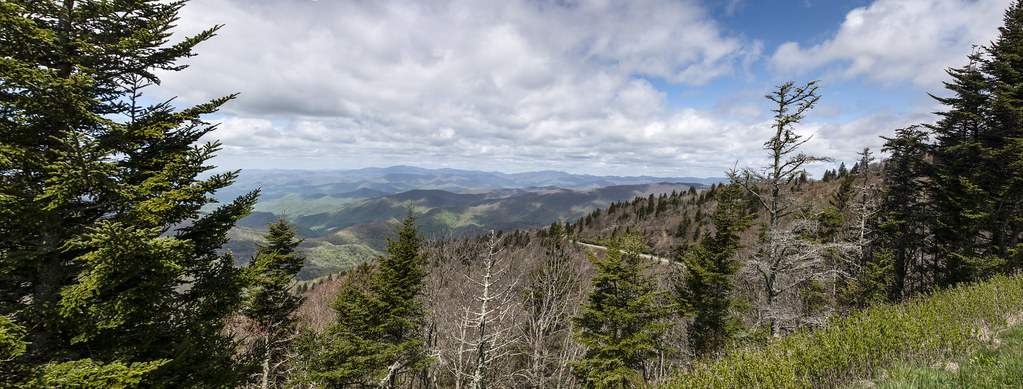
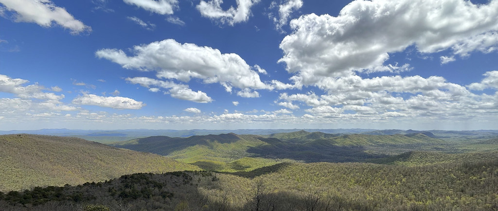
1. From Cherokee to Asheville, the scenery was very wooded and mountainous with lots of tunnels through the mountains and lots of steep uphill’s and downhills. Very few intersecting access roads and an awareness that there is nothing as far as the eye can see.
2. From Asheville to Boone, the scenery was less wooded, less tunnels, and a bit more gentle grades. More access roads and seeing towns and a few houses off in the mountains.
3. From Boone to Fancy Gap, the scenery is pastoral, with some open fields and gentle rolling pastures. Cattle and horses and passing some farms and towns within sight of the Parkway. I don’t remember any tunnels. Much more populated areas but still quite a secluded drive. They were beginning to start paving work on parts of this section. We encountered a closed portion and a long detour. After the detour and returning to the Parkway we waited for another section of single lane. By then it was getting late so we jumped off and took highways to Fancy Gap.
4. We enjoyed driving on the Parkway because there was almost no other traffic. We could look around, stop at any of the overlooks, and seldom saw other cars. The tunnels were not a problem. The only thing we needed to watch out for was overhanging branches but with no oncoming traffic it was easy to move over to miss them. I am sure it is a beautiful drive in the fall but I would not want to crawl along with lots of leaf peepers.

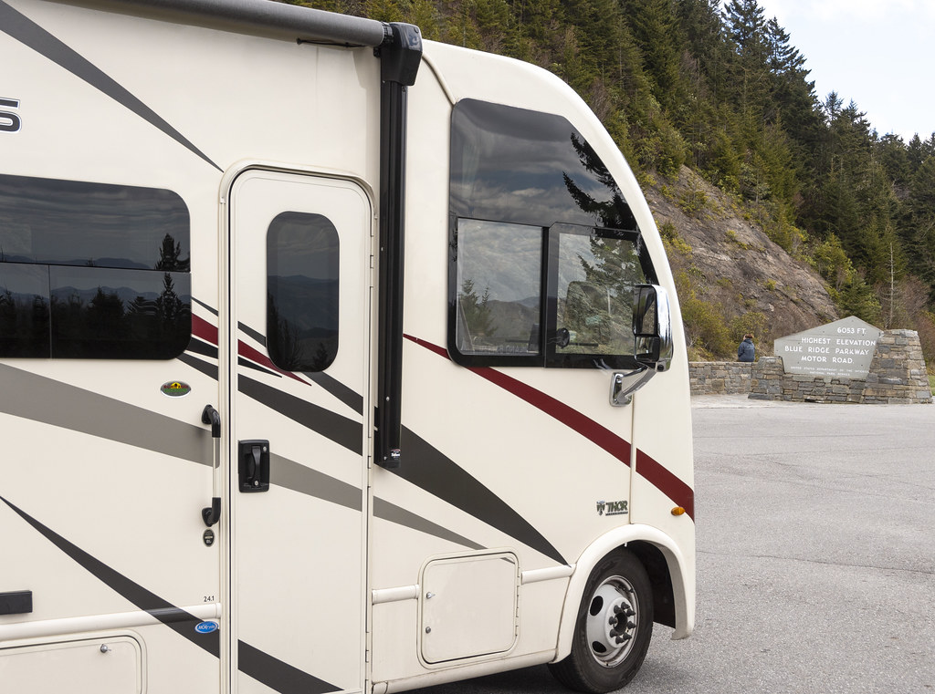
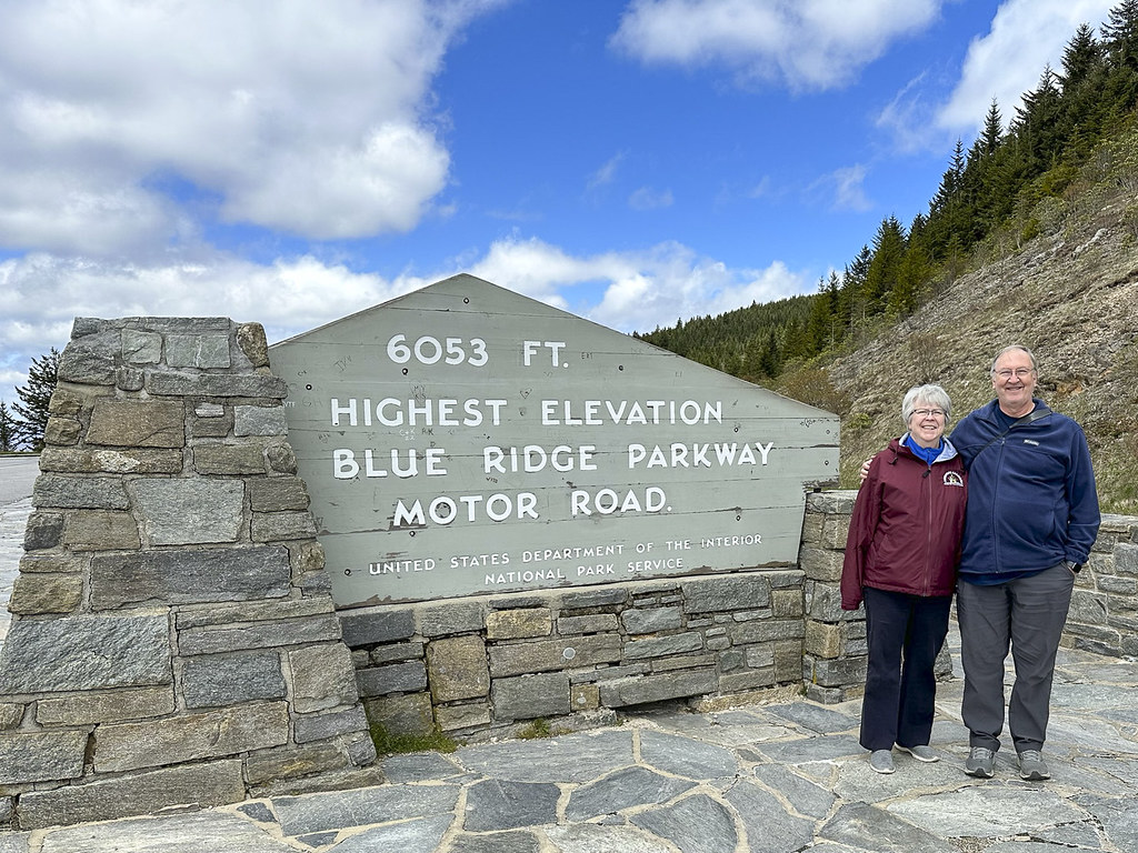
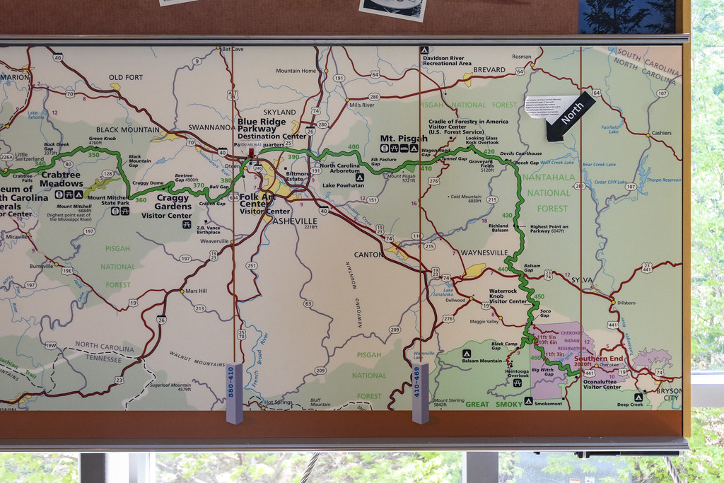
The entire BRP is 469 miles long. We drove 84 miles, from 469 at the southern end to 384 at the Asheville Visitors Center on the first day. 93 miles from 384 to Boone at 291 on the second day, and (most of) 92 miles from Boone to 199 at Fancy Gap on the third day. So we traveled (mostly) 270 miles on the Parkway (57% of the whole). Hopefully, someday, we can travel the northern end to Shenandoah National Park.

Tomorrow we leave the Blue Ridge Parkway and head north to West Virginia, New River Gorge National Park, and Babcock State Park.

Blue Ridge Parkway: Cherokee to Asheville, NC

Blue Ridge Parkway_RESTAURANT_PANORAMA-1

11 of 13 Jekyll Island Trip Series.

The beautiful Blue Ridge Mountains. A panoramic series of shots stitched together.

Before jumping onto the Blue Ridge Parkway we filled the RV up with gas. While I was doing that, Becky went into a little restaurant for coffee and donut holes. Highly recommend Mable’s Kitchen for breakfast. They don’t have donut holes on a shelf, you order them and they put them in the fryer. They are hot, fresh, and delicious.

Blue Ridge Parkway_IMG_3328
Just getting started on the Blue Ridge Parkway (BRP). This sign at the Cherokee entrance.
Blue Ridge Parkway__DAD6834
Didn’t get very far and had to pull over on one of the many overlook parking areas. Very little traffic and plenty of space. We only went 84 miles but it took us all day because we stopped at so many of the overlooks.
Blue Ridge Parkway__DAD6840
It being May 1st we were not expecting “fall colors,” but the “spring colors” were great!
Blue Ridge Parkway__DAD6897
Rhododendron were not flowering; but the Dogwoods were.
Blue Ridge Parkway__DAD6916
Blue Ridge Parkway_IMG_3330

We (and the RV) made it to the highest point on the Blue Ridge Parkway at 6,053′.

It was a cool spring morning when we left Cherokee. The rocks along the parkway had little waterfalls of melting water. Up here the rocks were covered with sheets of ice and icicles. We didn’t see it snow but people at the Pisgah Inn where we had lunch said it snowed the night before.

Blue Ridge Parkway_BUNCHES BALD_PANORAMA-1
Panorama from “Bunches Bald” overlook.
Vacation Sept 2013_DAD2113
Blue Ridge Parkway_OVERLOOK_PANORAMA-1

The photo on the left is from “Waterrock Knob” Visitors Center when Becky and I visited 10 years ago in September 2013. Our plan then was to visit Smoky Mountain NP and drive the Blue Ridge Parkway… but, because of the fog, we got this far and decided to just come down out of the mountains and drive east to visit Kitty Hawk.
The weather in 2023 was wonderful. The photo on the right is from the same place (Waterrock Knob Visitors Center) but looking a bit to the ‘left’ of the 2013 photo.

Blue Ridge Parkway_OVERLOOK2_PANORAMA-1
Waterrock Knob looking to the right.
Blue Ridge Parkway_PISGAH_PANORAMA-1
Panoramic view from the observation deck at Pisgah Inn.
Blue Ridge Parkway_IMG_3335
There is a nice restaurant at Pisgah Inn. We enjoyed lunch and the beautiful view out the big restaurant windows. Someone offered to take our pic. If we look a little frazzled there is a reason. The parkway is a two lane road with no curbs on the edge and almost no guardrails. It was really windy. As we rounded a bend there was a tree fallen across both lanes and well beyond. The tree had just fallen and a few cars were driving down a grassy ditch, out around the tree, and back down and up to the road through the ditch on the other side. There was no place to turn an RV around and cars were starting to stack up on both sides of the fallen tree. Not knowing if we would sink into the grass or bottom-out in the ditch we went for it. Rolling back and forth like a drunken sailor we made it around. Praise the Lord. That was not the Blue Ridge Parkway experience we expected… We will be getting a dash camera so we have proof next time we go off-roading in a 12,500lb RV.
Blue Ridge Parkway_QUALLA INDIAN RESERVATION_PANORAMA-1
Blue Ridge Parkway_OVERLOOK4_PANORAMA-1
Last panorama from the BRP on our first day. So grateful that the generations before us decided it would be a good idea to use taxpayer dollars to build a parkway through the mountains and to protect a large portion of the mountains from development so we can all enjoy these views.

We stayed at the Asheville East KOA for the night then visited the Ashville BRP Visitors Center and the Folk Art Center the next day.

Blue Ridge Parkway__DAD6931
Quote on the wall entering the Visitors Center. Vision Statement for the Parkway.
Entry to Asheville Blue Ridge Parkway Visitors Center

Entry to Asheville Blue Ridge Parkway Visitors Center

Blue Ridge Parkway_ASHEVILLE VISITORS CENTER_PANORAMA-1
Interior of the Ashville Blue Ridge Parkway Visitors Center.
Blue Ridge Parkway__DAD6930
Examples of wood work done with Chestnut Tree wood. Most chestnut trees were wiped out by blight.
Blue Ridge Parkway__DAD6921
The green line is the BRP. The small portion we drove on May 1st is from Cherokee (at bottom right) to Ashville (basically where it says Folk Art Center a little left of center on the map).
Blue Ridge Parkway__DAD6922
The entire 469 mile long Blue Ridge Parkway from Shenandoah National Park to Smoky Mountain National Park. We drove a little over 1/2 of the length in 3 days of about 90 miles a day.
Blue Ridge Parkway2__DAD6920
Couldn’t resist a pic of this pic. Not sure if the guy in boots and stubby tie is an Engineer or a Landscape Architect. Whoever he is it looks like he’s trying to impress the photographer. I am impressed by the stone masons building the nearly flat arch in the background!
Blue Ridge Parkway__DAD6924
Another pic of a pic. We will be driving on this Linn Cove Viaduct tomorrow (but without the fall colors or the helicopter view).
Blue Ridge Parkway__DAD6938
This orange flowering azalea is the only photo I have from the Folk Art Center. No photography is allowed. There were so many things I wanted to take photos of to remember! Alas, they would prefer we purchase them but that would require winning the lottery.

The Folk Art Center is incredible. It is home to the Southern Highland Craft Guild. The woodworking, quilting, textiles, carving, wheat weaving, pottery, etc., etc. is mind-blowing, beautiful, best-of-the-best stuff. This is a “must visit” place. I was thinking that visiting Biltmore was the most impressive thing to do in Asheville. The Folk Art Center may top that.

Cherokee & Great Smoky Mountains National Park, SC

10 of 13 Jekyll Island Trip Series.

We camped at Cherokee KOA after a long drive, made longer by our stop at Ninety Six National Historical Site. It was fun leaving the flat coastal areas we had been visiting for three weeks and heading inland to start our next goal of; “Drive the Blue Ridge Parkway”.

Cherokee_Smoky Mtn NPIMG_3322
Got the stamp at GSMNP Oconaluftee Visitors Center. This is the Eastern entrance to GSMNP just outside of the town of Cherokee, NC.

We stayed in Cherokee because the Blue Ridge Parkway ends (or in our case, starts) in Cherokee as the Southern terminus of the BRP. We had a day to rest before starting the BRP so we drove into GSMNP. The RV did great motoring up to the top of Newfound Gap and the views were wonderful out the big front windshield.

Cherokee_Smoky Mtn NPIMG_3313
View of clouds on the mountain from our campsite this morning. Reminded me of Smoky Mountain backpacking adventures in younger days.
Cherokee_Smoky Mtn NP_DAD6811
View from the Oconaluftee Visitors Center.
Cherokee_Smoky Mtn NP_DAD6807
There was a chicken wandering around loose at the Visitors Center. I stopped worrying about bears.
Cherokee_Smoky Mtn NP_DAD6827
We made it to the top at Newfound Gap. That’s our Axis RV in the parking lot. The only RV in the parking lot, hmmmm…
Cherokee_Smoky Mtn NPIMG_3314
Cherokee_Smoky Mtn NPIMG_3321

Admission to GSMNP is free but there is now a ‘parking fee’ if you are going to stop and park anywhere in the park longer than 15 minutes.

Cherokee_Smoky Mtn NP_DAD6826
The Appalachian Trail (AT) mostly follows a mountain ridge inside of GSMNP. Here at Newfound Gap the trail crosses the road and picks up again on the edge of the parking lot. Only 1,972 miles to the Northern end of the trail at Mount Katahdin in central Maine.
Cherokee_Smoky Mtn NP_DAD6825
Views from Newfound Gap
Cherokee_Smoky Mtn NP_DAD6823
Cherokee_Smoky Mtn NP_DAD6820
Cherokee_Smoky Mtn NP_DAD6817
At the bottom of Newfound Gap Road, near Cherokee, the road follows along the Oconaluftee River. The water is so clear!
Cherokee_Smoky Mtn NP_DAD6831
This area of the woods was full of white flowers blooming
Cherokee_Smoky Mtn NP_DAD6812
Ending this post with a bunch of beautiful butterflies. There were a bunch of bees too so I didn’t stay long. Someone had spilled something sugary on the pavement-not very natural but the butterflies were cool… (maybe pipevine swallowtails?)