18 of 22 – 2024 Fall Trip West Series. 10/7/24 Monday. After a quick visit to Walnut Canyon we drove to Petrified Forest National Park. We entered at the South Entrance and stopped first at the Rainbow Forest Museum/Visitors Center. This is a ‘drive through’ park with one 28 mile long road. Lots of places to pull over and take pictures or go for short hikes. The road is smooth in a few places… but mostly it is awful. Took us several hours to travel those very bumpy 28 miles.
The Visitors Center had some beautiful examples of polished petrified wood
Red petrified wood.
Even unpolished petrified wood is quite colorful.
Cactus. The only picture I have of something living in this very barren desert area.
There is a lot more than just petrified wood to see on the drive. Wild and unusual landforms and colors abound.
Petrified wood was just laying around everywhere.
While we were at this overlook toward the end of the drive, we saw another RV very similar to ours pull up. We enjoyed a brief meeting with the “rv_lifestyle_asianfamily” family and have followed their travels since on Facebook and Instagram.
Our RV on the right, Brenda & Tiger family on the left. Their Instagram is rv_lifestyle_asianfamilyThey took a picture too and posted to their Instagram; this is a screen capture of that post. We very seldom see another Axis/Vegas while driving so to have one pull up and park is cause for some celebration. Hats off to them traveling in a 25′ RV with a family of four and a dog.
One last picture as we were finishing the drive out of Petrified Forest NP. It was starting to get hazy so not a very good pic but that pyramid rock standing by itself was just weirdly interesting.
We stayed the night at Grants KOA in Grants, New Mexico. The campground was right next to an old lava flow. This pic was from the lava right at the entrance. Driving along US 40 the whole area just looked like desert to me with a few hills and ridges. I had no idea there were old volcanos around until we stopped to camp. The next morning we drove a very short distance to El Malpais National Monument.
Malpais is from Spanish, meaning “Badlands” (due to it’s location in the midst of volcanos and lava flows).
Topographic map of El Malpais. Volcano (Mt. Taylor) is in upper right. Various lava flows are the grays and black on the map. US 40 goes right between them.
The Visitors Center had some beautiful pottery.
We stayed the night at a big casino called Route 66 RV Resort which is on the outskirts of Albuquerque, NM. This was our most expensive night of camping the whole trip ($110) and possibly the hottest night too. It was hard to find reservations at campgrounds anywhere around Albuquerque because of the Balloon Fiesta.
17 of 22 – 2024 Fall Trip West Series. 10/5/24 Saturday-Monday. We left Hurricane, UT and headed south to Flagstaff, AZ where we stayed for two nights.
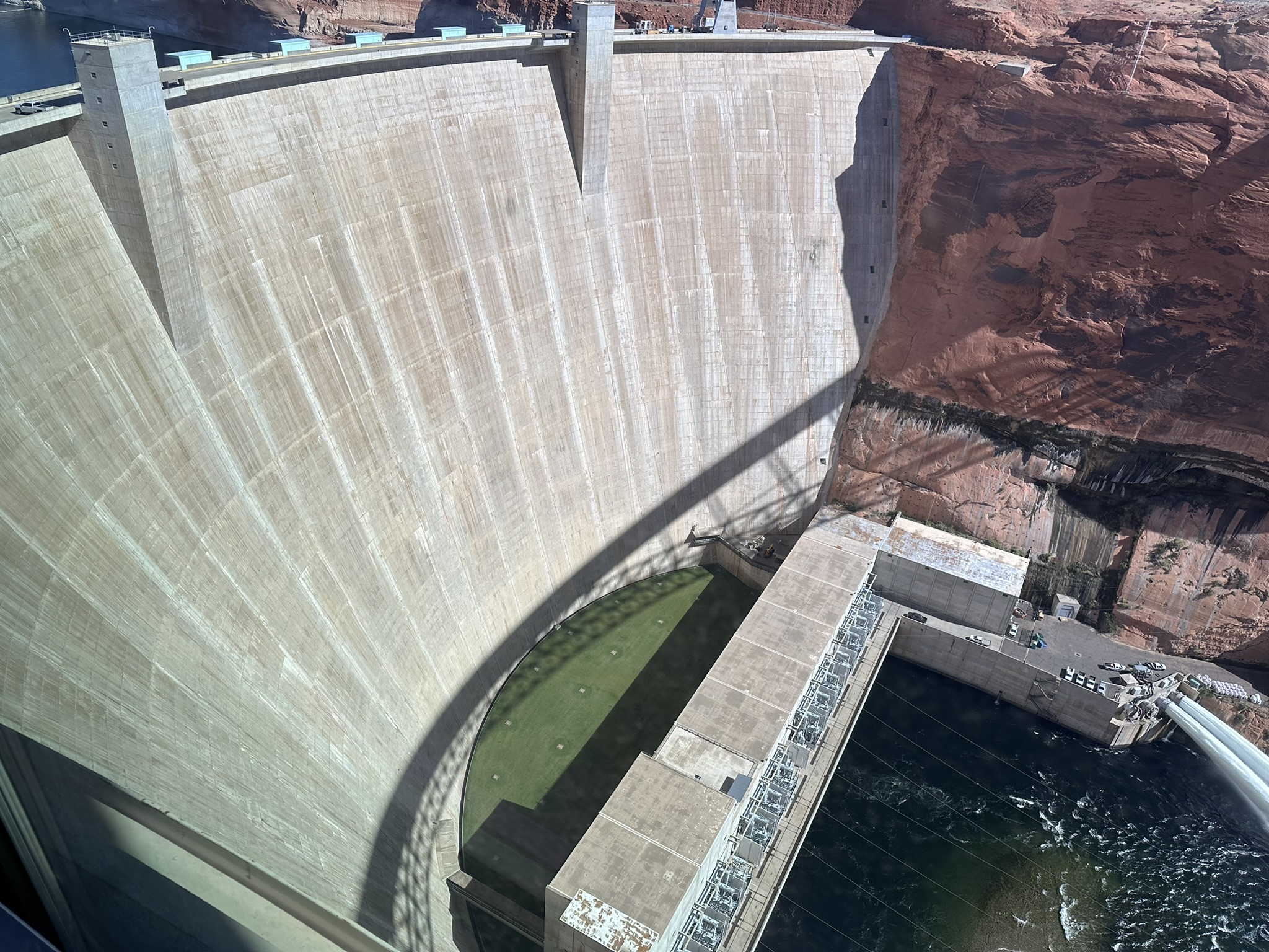
Our first stop on the way was Glen Canyon Dam and Lake Powell. The Visitors Center at Glen Canyon Dam is very nice. It is run by volunteers eager to tell lots of “Dam” this and “Dam” that jokes. This photo is a stitch of 3 iPhone pics taken by holding the phone out and pointing through an opening in a fence. Wonky but best pic I have.
Glen Canyon Dam.
3 pics that Photoshop stitched together to make the composite photo above. I think that’s pretty amazing stuff.
Artists drawing of the canyon location picked to locate the Dam.
Lake Powell. Seems sort of ironic that the lake is named after the guy who is famous for exploring and mapping the whitewater rapids of the Colorado River that the lake now floods… The lake is at about 36% of it’s capacity.
Scenery around Lake Powell.
Got the stamp. It was while getting the stamp I realized how close we were to the Horseshoe Bend and that it was part of the area the stamp included. We decided to head there next.
Horseshoe Bend is down in that hole in an otherwise flat desert. There is a paved .75 mile walk from the parking lot to the overlook. It was brutally HOT when we were there so we didn’t stay to look very long but it was worth the stop.
Lots of people were leaning out and getting better pictures of the full Horseshoe Bend in the Colorado River. I was overheating and getting tipsy being this close to the edge.
Picture of a picture of the whole Horseshoe Bend. People had set up lots of rock cairns.
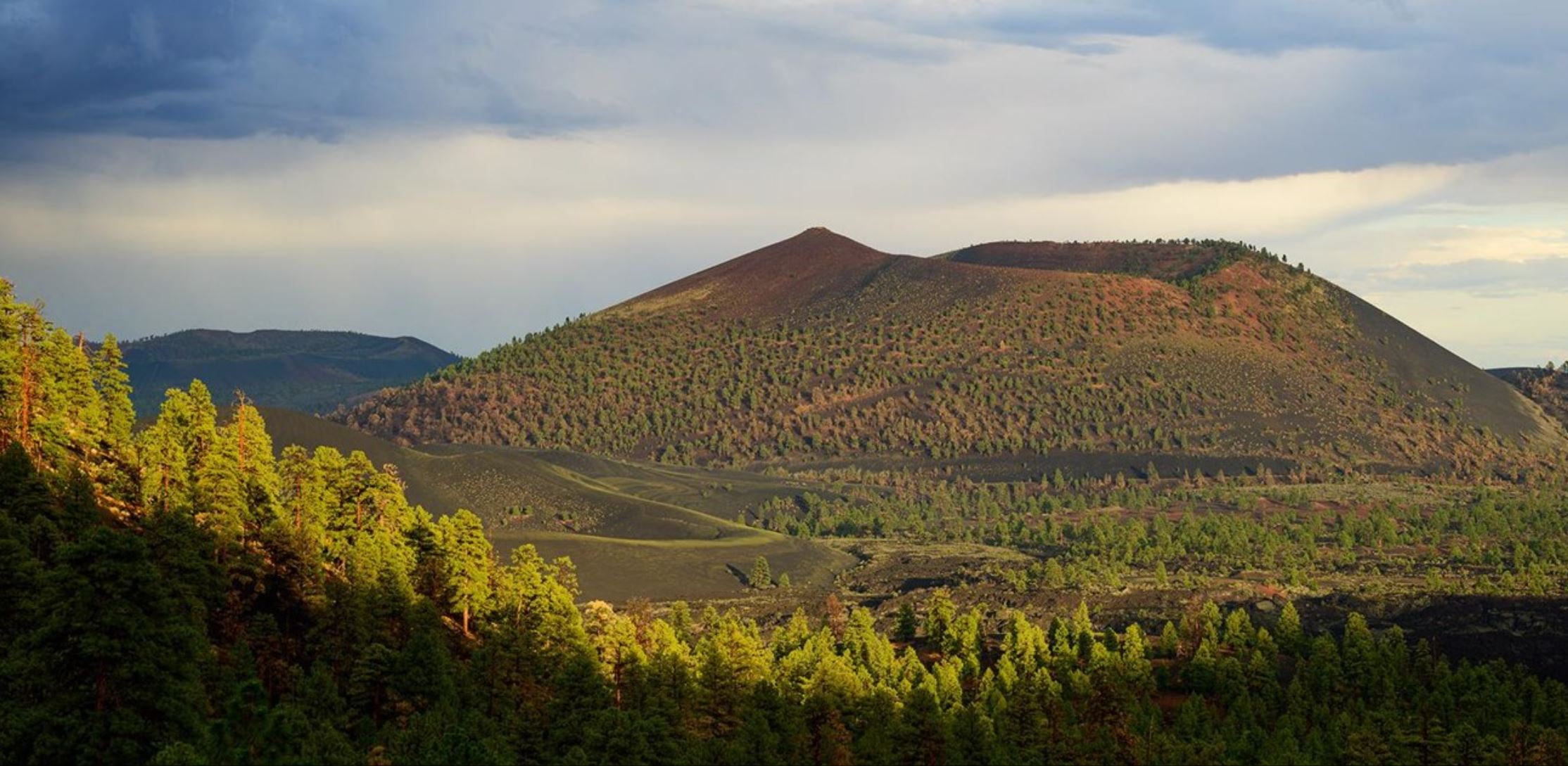
Sunset Crater Volcano National Monument. It is not very impressive to view from down on the road level so here’s a picture from a higher viewpoint from National Park Service website.Our campsite at Flagstaff KOA. After two nights at Flagstaff KOA we headed back East toward Albuquerque on US 40. We would be traveling on US 40 for much of our way back. Out west US 40 parallels or overlays the old Route 66.
Map of old Route 66. We traveled this on what is now US 40 from Flagstaff, AZ to Oklahoma City, OK.
Our first stop after leaving Flagstaff was Walnut Canyon National Monument.
The canyon was formed by Walnut Creek which drains into the Colorado River. Cave dwellers made homes here under the overhanging rock ledges in the 12th and 13th centuries.
Amazing watercolor paintings by Michael Hampshire on display at Visitors Center.
It was fun to watch the ravens soaring in the canyon. Leaving Walnut Canyon National Monument we again headed west to Petrified Forest National Park.
16 of 22 – 2024 Fall Trip West Series. 10/4/24 Friday. We got up early and drove in two cars up to Zion National Park South Entrance. We had been advised to get there early in order to get parking inside the entrance at the Visitors Center. If too late we would need to park outside in the town of Springdale and walk in which could take awhile. Becky stayed back at the house to catch up on laundry and get us ready for tomorrow when we leave Deanne and the kids for the next part of our trip toward the Albuquerque Balloon Fiesta.
South Entrance and view up Zion “Valley of the Gods” at sunrise. Photos on this post are a mix of shared iPhone pics by everyone.
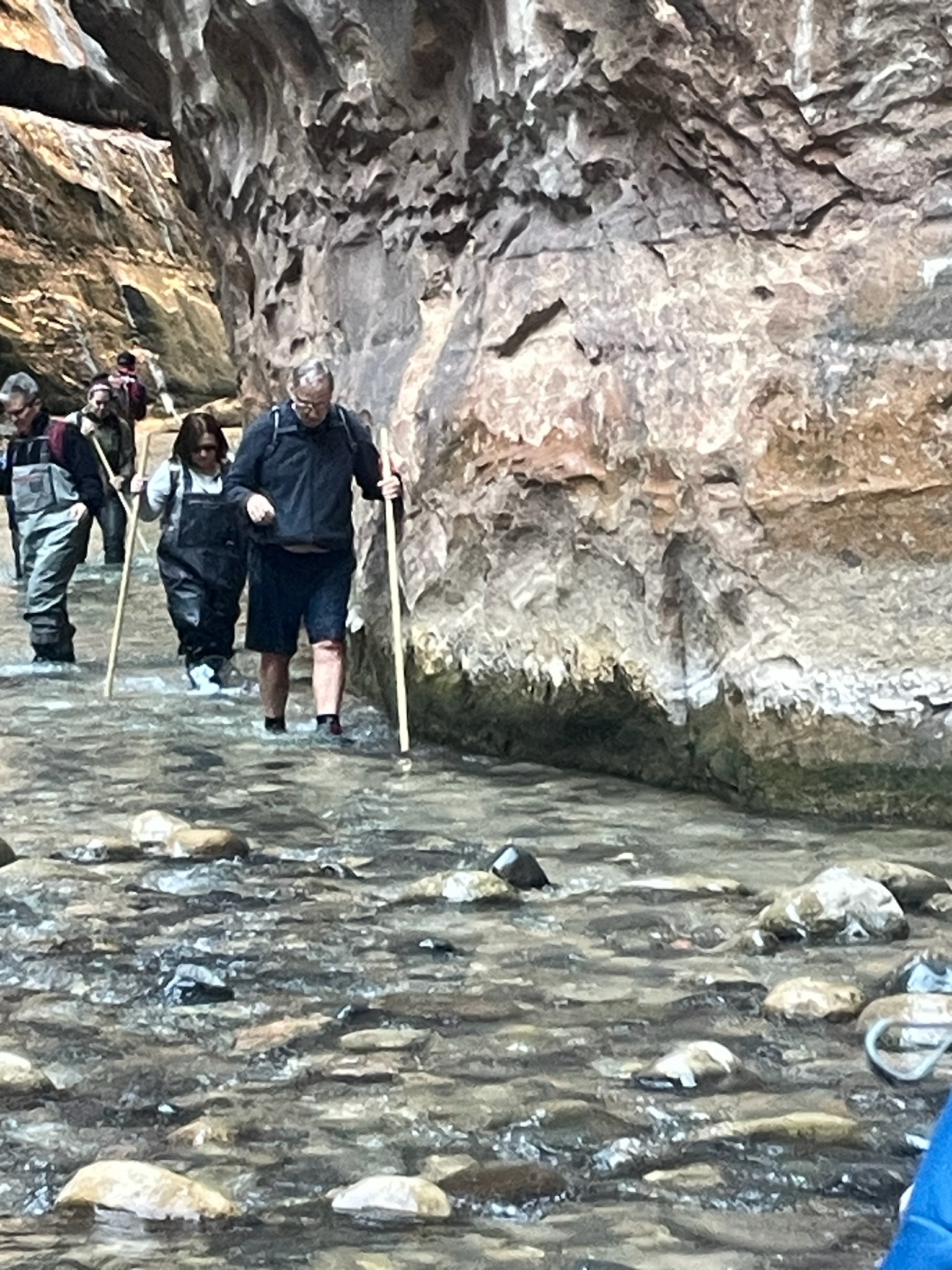
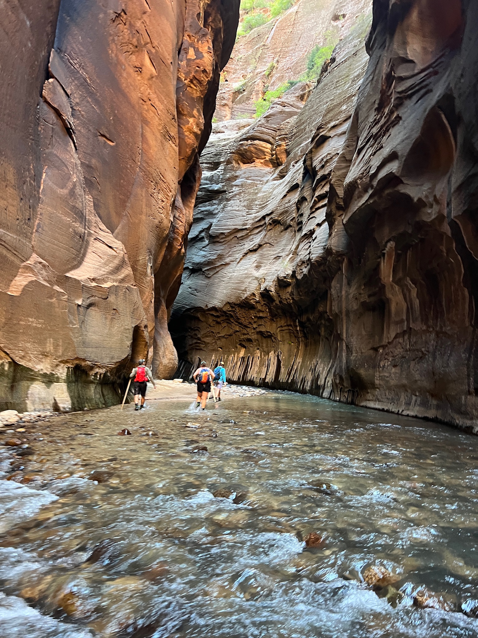
The “Rock Hounds” prepared to set off up The Narrows with our rented neoprene socks, rubber boots and walking sticks.
The infamous “Rock Hound Howl”
Deanne rented the whole-body suit. That’s me on the right hugging the wall and trying to not fall down. I found out that 17 years makes a lot of difference. Becky, me, Liz, and David did this hike in the Narrows in 2007. I remember it being cold but not difficult. Today, because of problems with balance I find it just about impossible. I nearly slipped down several times and was going so slowly that everyone went on ahead except Liz and Deanne who stayed back with me. Once I fell in and got pretty wet and cold I gave up and sat down to rest and dry out. Deanne and Liz went on but did not catch up with the other Rock Hounds.
I sat here waiting for the sun to come up enough to get down in the canyon to warm me up and dry me out. A beautiful place to sit and ponder getting old and feeble…
When we got back to the starting point at the Visitors Center I had no dry socks or shoes to put on because they were in the ‘other’ car. I bought Zion socks at the Gift Shop and crashed when we got back to the rental house.
Couple pics of much younger Liz and David in 2007. Not part of this trip but happy memories. That photo of Liz in the green water is one of my favorites.
Deanne took this pic the next day when she and the kids all rented ebikes in Zion. We wished we could have stayed longer but had to leave Hurricane and the group to head south.
There were two major highlights of this trip. The first was the wonderful family time we had here in Utah. The second was the time at the Albuquerque Balloon Fiesta.
15 of 22 – 2024 Fall Trip West Series. 10/3/24 Thursday. We visited Arizona today. We drove to the North Rim of the Grand Canyon with a stop along the way at Pipe Spring National Monument.
There are still reliable springs of water here in this otherwise very dry, desert area. This area had the only water available from Hurricane, UT to Fredonia, AZ for Mormon settlers.
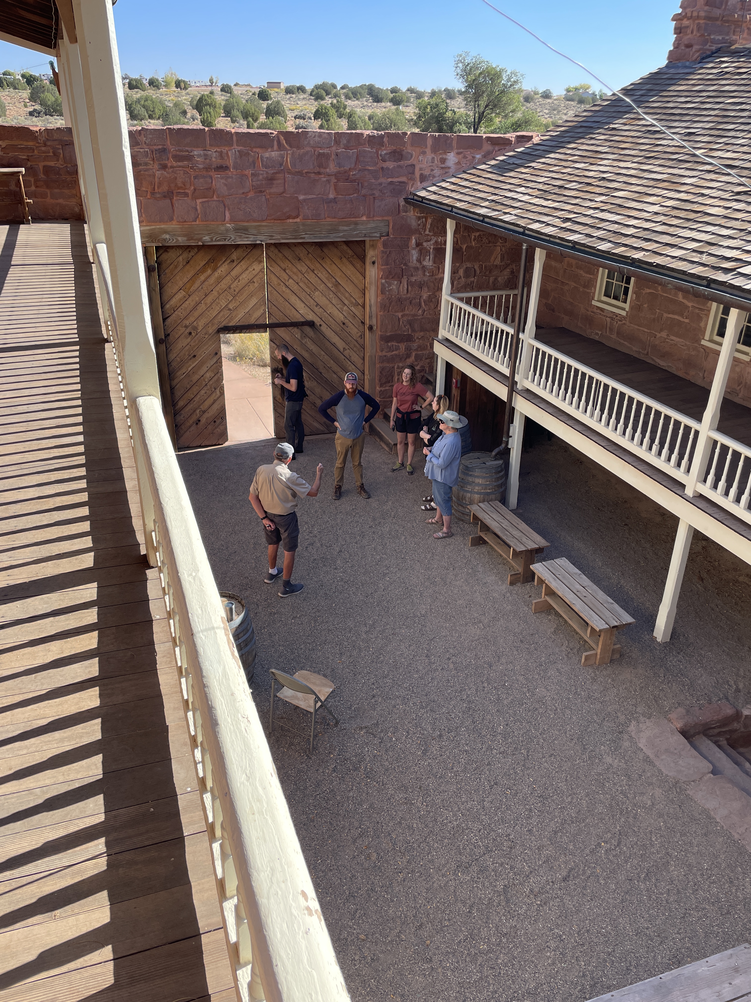
“Winsor Castle” is the name given to the fort ordered built by Brigham Young (1870) to protect early Mormon settlers and the important spring inside the fort. The “main spring” was inside Winsor Castle but it has dried up and is now emulated with pumped water. Other springs around the site continue to have water and were an important feature for over a thousand years bringing peoples to settle, farm, and ranch here.
Plaque reads: “Pipe Springs National Monument established May 31, 1926 through efforts of Stephen T. Mather and friends. Pipe Springs: occupied in 1863 by Dr. James M. Whitmore, who, with Robert McIntyre, was killed 4 miles S.E. of here January 8, 1866 by Navajo and Piute Indians. Winsor Castle: erected by direction of Brigham Young in 1869-70 by Anson P. Winsor for handling the church tithing herds and as a frontier refuge from Indians. It became the first telegraph office in Arizona when the Deseret telegraph line reached here in December 1871.”
Inside porches at Windsor Castle.
Leaving Pipe Spring National Monument we traveled on to the North Rim of the Grand Canyon. Beautiful fall colors along the way.
Arriving at Grand Canyon National Park North Rim Visitors Center we found parking and had a quick lunch before walking along the rim to various overlooks. Self shadow portrait of Indiana Dad.
Eric & Jackie posing with their pre-wedding photographer Lauren.
All the travelers on the overlook except David who relaxed in the sun and Duane and Becky who relaxed in the shade of the hotel lobby (and took the pictures…)
Point Imperial is the highest point in Grand Canyon National Park.
We ate here in Hurricane after a long day driving to Grand Canyon and back. We got back just in time to rent equipment to hike ‘The Narrows’ at Zion the next day.
14 of 22 – 2024 Fall Trip West Series. 10/2/24 Wednesday. The kids arrive today! Deanne rented a house in Hurricane and her kids and our kids would arrive this evening, all staying at the house. Joey & Lauren, Jackie & Eric drove in from Kansas in Deanne’s brand new minivan. Nathan, Lizzy & David flew into Los Vegas from Indianapolis. They rented a car in Los Vegas and drove up to Hurricane after stopping for a tour of Hoover Dam and Valley of Fire State Park. In the morning we did some grocery shopping to stock up the house. Then we went for a drive to see some of Zion NP before the kids arrived.
We drove from Hurricane up to Zion NP south entrance and on through the park toward the east entrance on Highway 9 known as the Zion-Mount Carmel Highway. The east entrance has tunnels that RV’s don’t fit through (they do but just barely, if you pay a fee to block oncoming traffic so you can drive down the middle of the road) so we hadn’t come through that way when we came to Hurricane. The tunnel was built by the CCC during the depression
The Zion-Mount Carmel Highway 9 is the black line on the map. The photos that follow were all taken on that route.
I think this rock formation is called “The Spearhead”. It is near the Visitors Center at the south entrance.
This is called “The Great Arch”. Not like the open arches in Arches National Park but at 600′ wide it is two football fields long. There is a large pullover area at one of the switchback bends near below the tunnel on the Zion-Mount Carmel Highway where you can stop and take pictures.
Approaching the Tunnel. (photo by someone in our group-thanks)
This beautiful pink rock formation is called “Crazy Quilt Mesa”
This white rock formation might be called “Progeny Peak” (but I’m not sure).
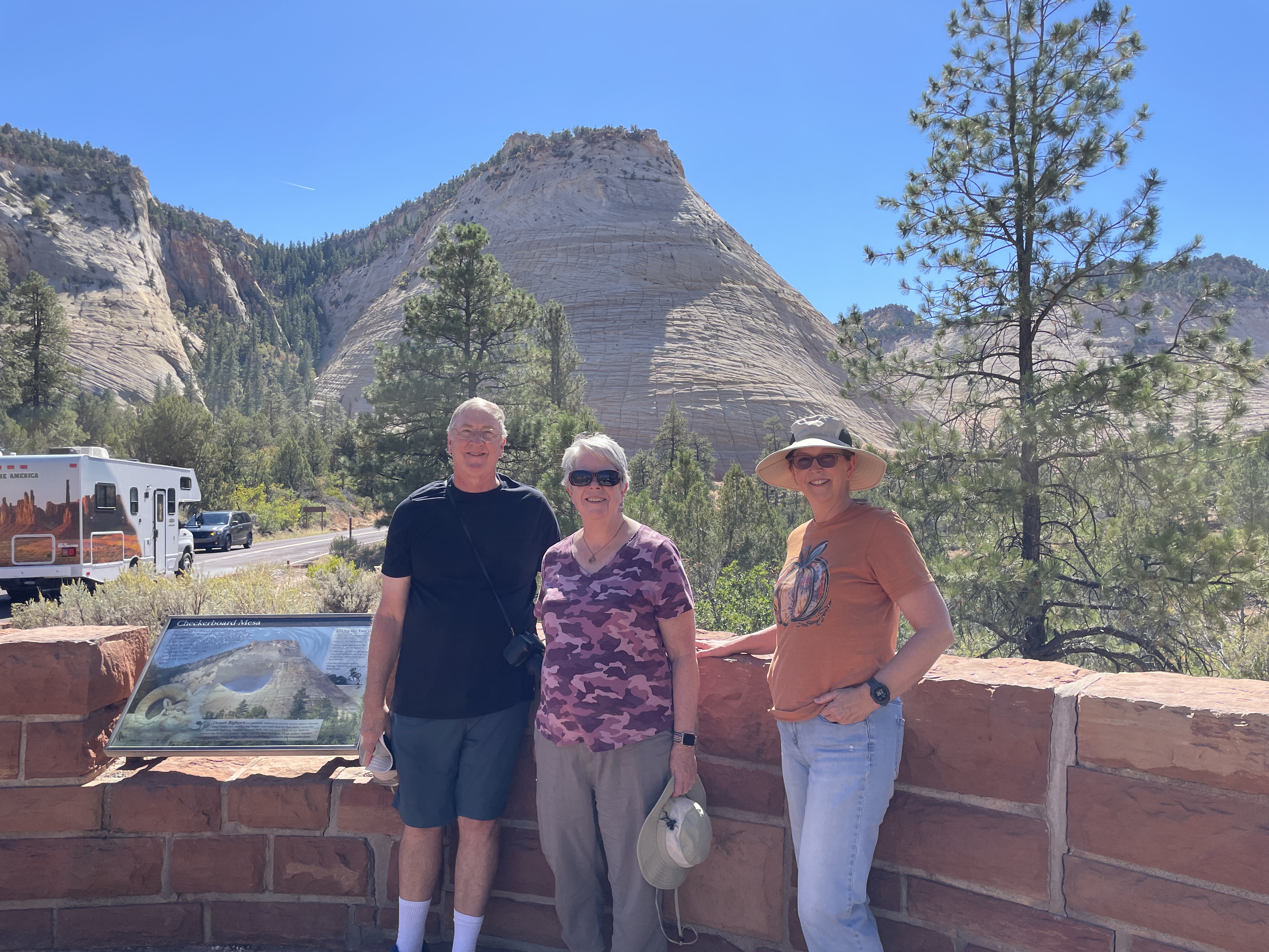
This and the next two photos are a criss-crossed formation called “Checkerboard Mesa”.
Some nice visitor took this picture for us with Checkerboard Mesa in the background.
13 of 22 – 2024 Fall Trip West Series. 10/1/24 Tuesday. We did a big road trip today to: Valley of Fire State Park, Hoover Dam, and Lake Mead. Valley of Fire State Park seems like it should be a National Park because it is huge and there is so much to see there.
In 2012, a rough road called the Arrowhead Trail was first built in this red rocky area to travel between Salt Lake City and Los Angeles. In the 20’s it became known as the Valley of Fire when a AAA official driving through at sunset said it looked like the entire valley was “on fire”.
We went for a short hike in the “White Domes” area. It was very hot and hard to walk in the soft sand.
Hoover Dam National Historic Landmark
Lake Mead was created by Hoover Dam. It is the largest water reservoir in the United States. The water level has been going down for many years and it currently holds less than 30% of the amount that Hoover Dam was designed for.It is a strange thing to see a big body of water in the middle of hot treeless desert.
12 of 22 – 2024 Fall Trip West Series. 9/29/24 Sunday. On our last day staying at Panguitch we visited Cedar Breaks National Monument. At over 10,000′ elevation this was the highest place we drove to (the Pikes Peak Cog Rail Train took us to over 14,000′). The scenery on the drive was spectacular with aspens in full yellow glory.
On the way we saw these young Pronghorns. I don’t think any of us had seen these before so we had to look them up to figure out what they were. Trivia: They are not antelopes or even related to them although sometimes they are called pronghorn antelopes. They are the fastest mammals in the Americas and can run 55 mph for long distances. Cheetahs are the only thing faster but for only short distances.
Cedar Breaks is a giant eroded amphitheater shaped wonderland. It is 3 miles wide and 2,000′ deep. Geologically it is at the very top height of “The Grand Staircase”. Cedar Breaks was not on the trip plan but Jennie suggested it. Not knowing anything about it made this unexpected view at the first overlook a very dramatic surprise!
Our group who traveled together from Kansas. This was our last group photo as Jennie and Roni would head back home tomorrow.
The photos just look so small. It’s sad they can’t convey the awesome magnitude of the scale and majesty of this place…
Leaving Cedar Breaks National Monument we headed down the mountain to Cedar City to get gas and find some place to eat. We had used a lot of gas getting up the mountain to Cedar Breaks and the warning light was on when we headed down. We coasted downhill so much that by the time we got to the gas station we had more ‘miles to empty’ than when we started down.
Last photo of our drive back to camp from visiting Cedar Breaks. Sorry to leave this beautiful part of the country behind as we travel to the more treeless desert of Zion tomorrow.
Becky’s Birthday flowers traveled in the RV sink on the next day’s drive from Panguitch to Hurricane.
The RV and rental car when we arrived in Hurricane, UT at the very nice WillowWind RV Park. We stayed here 5 nights.
11 of 22 – 2024 Fall Trip West Series. 9/28/24 Saturday. Deanne and I got up early and drove back to Bryce Canyon to hike “Wall Street”. The trail is 3.2 miles long. The descending Wall Street portion is part of the Navaho Loop Trail and the ascending portion is called Queen’s Garden.
Wall Street starts down from Sunrise Point Overlook. All pics of this hike are from our iPhones. I figured I could get down the trail but getting back up to the rim would be challenge enough without lugging the big camera.
The view from Sunrise Point.Deanne took this picture of me the day before when we checked out the top of Wall Street and decided to come back to hike it.
Starting the Wall Street hike, looking down the switchback trail.
Deanne heading down the trail. Me with Nathan’s borrowed hiking poles. They helped a lot.
Nearing the end of the initial switchbacks there is a narrow opening into a deep slot canyon.
Turning around and looking back up the canyon from the slot.
First sight of the Douglas Fir trees growing tall in the narrow canyon.
Taking a break on the way back up the Queen’s Garden trail. It was starting to get pretty warm and I was getting pretty worn out but the views down in the canyon were beautiful and I was determined to finish this.
View looking out and up from where we were resting.
Beautiful wildness.
The trail was similar to this much of the way
Deanne got to the top first.
All smiles, not even tired.
We did it! That completes the Wall Street hike. After taking a break at the park store we gingerly levered ourselves back into the car for the drive back to Panguitch. We stopped for a few pictures of Red Canyon on the way back.
The red rocks of Red Canyon. Trivia: Near this location is The Butch Cassidy Draw, a trail used by none other than famous outlaw Butch Cassidy (real name Robert Leroy Parker). Much of the film Butch Cassidy and the Sundance Kid was filmed here in Red Canyon. On our way to Panguitch we had driven past the childhood home of Butch Cassidy which is alongside Highway 89. We didn’t stop then but after we learned of his childhood in the area I wish we had.
10 of 16 – 2024 Fall Trip West Series. 9/27/24 Friday. A beautiful day to visit the otherworldly Bryce Canyon NP.
Panguitch; a Paiute Indian word meaning “big fish” how do you pronounce that town name? Not Pan-gu-itch. Think of “Penguin Sandwich,” that’s how we were instructed by the owners of Dixie Forest RV Resort where we were staying; “Peng-wich”. The elevation at Panguitch is 6,666′. The elevation at the rim of Bryce Canyon is 8,500-9,000′
Beautiful fall colors at the Bryce Canyon “Natural Bridge” overlook.
Beautiful drive to many outlooks along the canyon rim.
Golden Aspen fall colors.
Deanne conversing with the raven.
Two pics above are both of the “Wall Street” canyon. The left is the top of the canyon, the right is looking down into the top of the canyon with lots of hikers on the trail. It was mid-day hot today so we decided to come back early tomorrow morning to hike “Wall Street”.
One last photo of the incredible Bryce Canyon before we headed down from the rim to Kodachrome Basin State Park.
View driving into Kodachrome Basin State Park.
Some wind spinners we saw along the road. The cliffs in the far background are Bryce Canyon.
Real cowboy ranchers on horseback were herding cattle down the road.
Becky’s Birthday came while we were at Panguitch. Flowers and M&M’s brightened up our campsite.
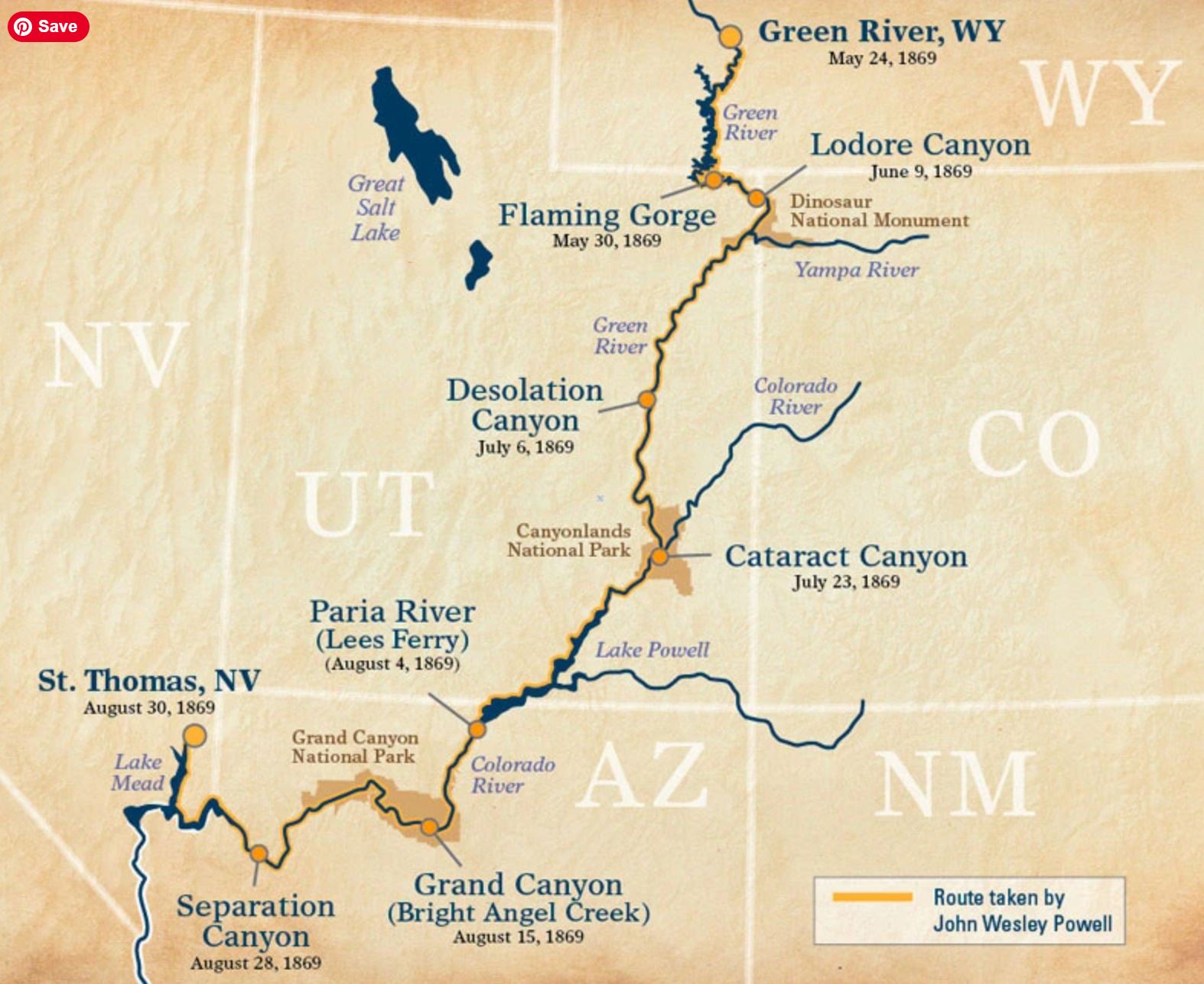
9 of 16 – 2024 Fall Trip West Series. 9/26/24 Thursday. We traveled from Moab to Panguitch, UT. We stopped at the John Wesley Powell Museum in Green River, UT, and we stopped at Capital Reef National Park. The museum was not on our agenda when planning the trip but Deanne had read about it and wanted to stop. We are glad we did.
Route of Powell’s first expedition in 1869. We would travel on to look down into Cataract Canyon in Canyonlands National Park, Lake Powell, Grand Canyon, and Lake Mead on our trip.
Crazy that little wooden boats would tackle raging rapids. Boat above is a replica of one of the boats lost at “Disaster Falls” on Major John Wesley Powell’s first trip down the Green/Colorado rivers in 1869. Disaster Falls is in “Ladore Canyon” in the map above. The original boats looked like a cross between a canoe and a rowboat. Deanne studying Colorado River lore.
Deanne activated this character when she walked up.
These are some improved versions of boats made to better maneuver and withstand the stresses of running whitewater river rapids. The look less like rowboats.
Dramatic sculpture in the museum. The Colorado River had a lot more water before flood control dams and irrigation. Powell and his team were brave explorers.
Loads of fossils are found in the area including these fearsome dinosaurs. I am glad they are gone.
I don’t remember where this is. There is a lot of desert between Moab and Panguitch. I thought the individual standing stones were cool. This may be somewhere near Goblin State Park which we drove past but did not stop at.
Our tiny RV parked along the road is dwarfed by “The Castle” landform on the left and “The Rim” on the right. This is near the Visitors Center. Capital Reef National Park was basically a “drive-thru” park. There was a lot of road and infrastructure construction going on and just about everything we hoped to see was closed. We enjoyed the things we could see on the main drive through the park, got the NPS Stamp, and moved on a bit disappointed.
The Castle.
We stayed for 4 nights in Panguitch at Dixie Forest RV Resort. Lots of stars on a clear night.
7 of 12 – 2024 Fall Trip West Series. Canyonlands National Park “Island in the Sky” and Dead Horse Point State Park. The “Island in the Sky” name refers to the 2,000′ high mesa the entire area is on (compared to the river valley floor below).
The Merrimack and Monitor: a pair of buttes named after the Civil War ironclad ships USS Merrimack and USS Monitor.
The road zigzagging down to the Colorado River Valley District in this photo is called The Shafer Trail. It’s a 19 mile long 4WD dirt road. The Shafer Trail road also shows up in the first photo of this post. It was originally a route made by Native Americans, then named after a 1916 era Mormon Settler “Sog Shafer” who improved it. The it was further improved and widened for large trucks bearing uranium rock by the Atomic Energy Commission. After Canyonlands became a National Park in 1964 it transitioned to today’s backcountry recreation trail. I couldn’t convince anyone to try it.
Layers upon layers upon layers.
Arches National Park has lots of Arches but Canyonlands has some too. This one is the famous Mesa Arch.
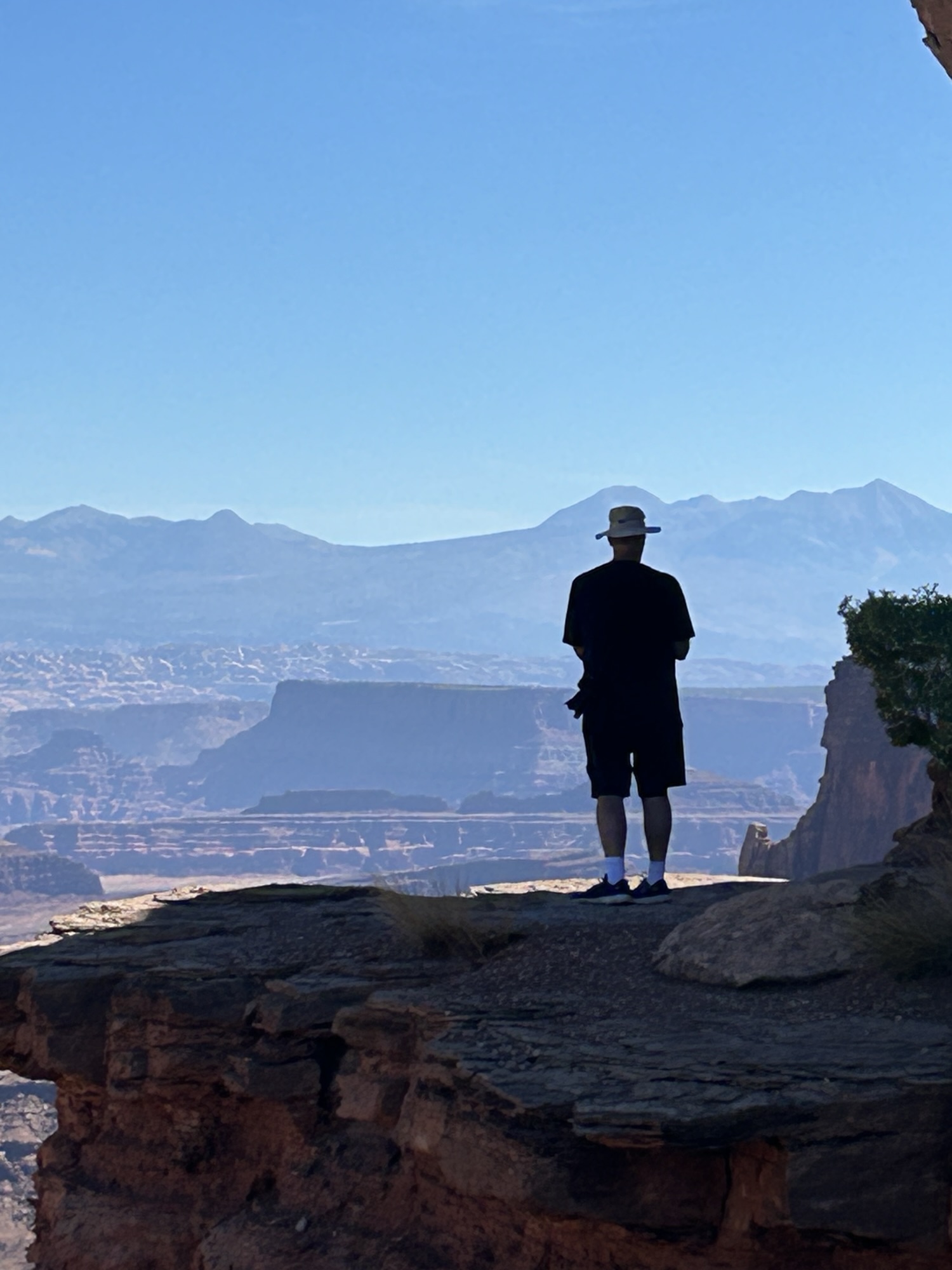
An Island in the Sky.
View from the overlook at Dead Horse Point State Park.
Sweeping views across canyon from Dead Horse Point State Park.