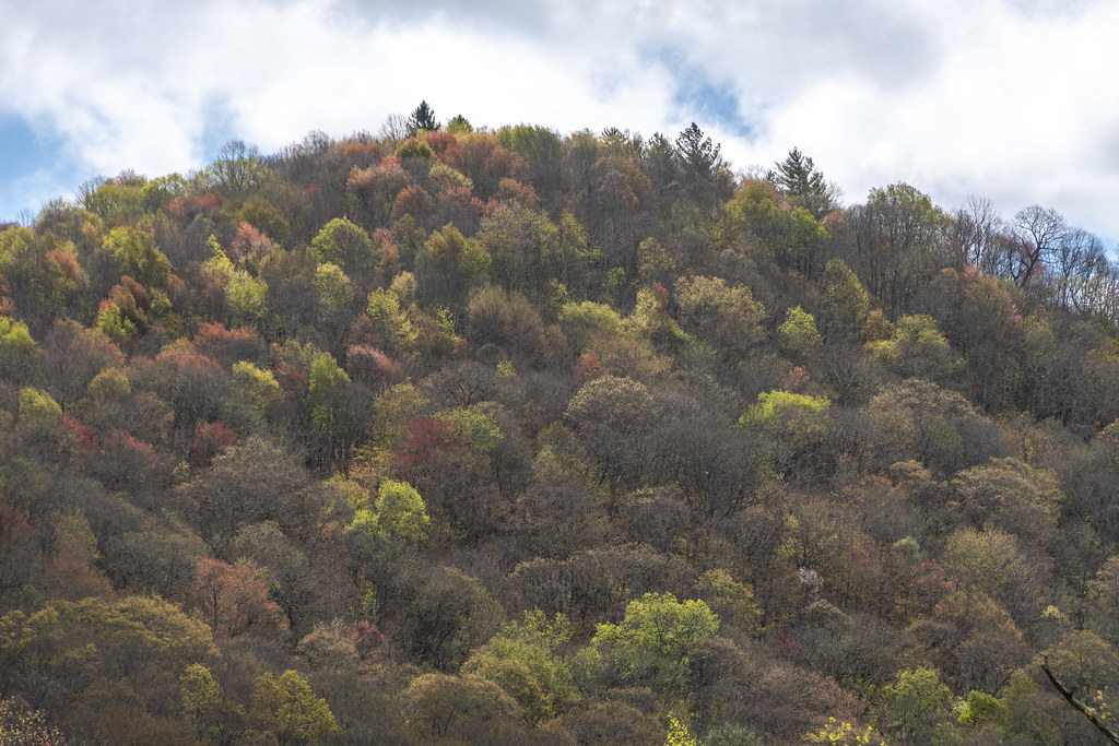
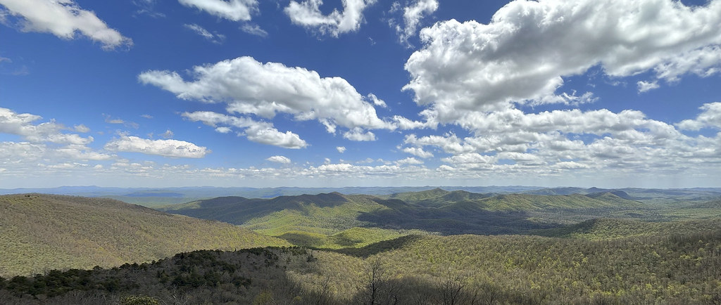
The beautiful Blue Ridge Mountains. A panoramic series of shots stitched together.
Before jumping onto the Blue Ridge Parkway we filled the RV up with gas. While I was doing that, Becky went into a little restaurant for coffee and donut holes. Highly recommend Mable’s Kitchen for breakfast. They don’t have donut holes on a shelf, you order them and they put them in the fryer. They are hot, fresh, and delicious.
Just getting started on the Blue Ridge Parkway (BRP). This sign at the Cherokee entrance.
Didn’t get very far and had to pull over on one of the many overlook parking areas. Very little traffic and plenty of space. We only went 84 miles but it took us all day because we stopped at so many of the overlooks.
It being May 1st we were not expecting “fall colors,” but the “spring colors” were great!
Rhododendron were not flowering; but the Dogwoods were.
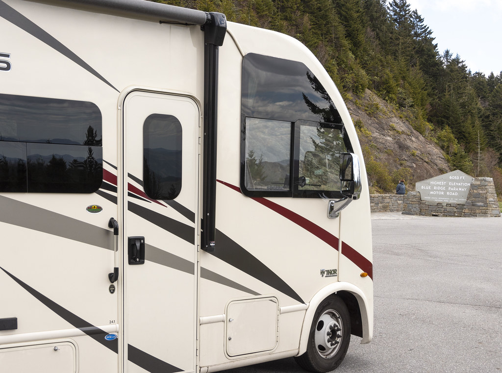
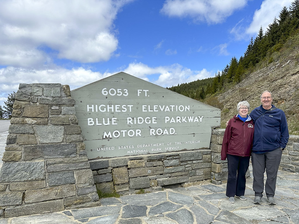
We (and the RV) made it to the highest point on the Blue Ridge Parkway at 6,053′.
It was a cool spring morning when we left Cherokee. The rocks along the parkway had little waterfalls of melting water. Up here the rocks were covered with sheets of ice and icicles. We didn’t see it snow but people at the Pisgah Inn where we had lunch said it snowed the night before.
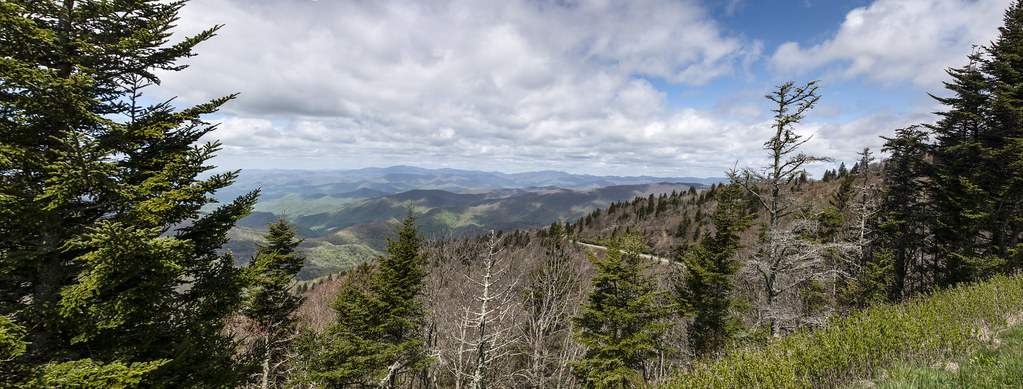
Panorama from “Bunches Bald” overlook.
The photo on the left is from “Waterrock Knob” Visitors Center when Becky and I visited 10 years ago in September 2013. Our plan then was to visit Smoky Mountain NP and drive the Blue Ridge Parkway… but, because of the fog, we got this far and decided to just come down out of the mountains and drive east to visit Kitty Hawk. The weather in 2023 was wonderful. The photo on the right is from the same place (Waterrock Knob Visitors Center) but looking a bit to the ‘left’ of the 2013 photo.
Waterrock Knob looking to the right.
Panoramic view from the observation deck at Pisgah Inn.
There is a nice restaurant at Pisgah Inn. We enjoyed lunch and the beautiful view out the big restaurant windows. Someone offered to take our pic. If we look a little frazzled there is a reason. The parkway is a two lane road with no curbs on the edge and almost no guardrails. It was really windy. As we rounded a bend there was a tree fallen across both lanes and well beyond. The tree had just fallen and a few cars were driving down a grassy ditch, out around the tree, and back down and up to the road through the ditch on the other side. There was no place to turn an RV around and cars were starting to stack up on both sides of the fallen tree. Not knowing if we would sink into the grass or bottom-out in the ditch we went for it. Rolling back and forth like a drunken sailor we made it around. Praise the Lord. That was not the Blue Ridge Parkway experience we expected… We will be getting a dash camera so we have proof next time we go off-roading in a 12,500lb RV.
Last panorama from the BRP on our first day. So grateful that the generations before us decided it would be a good idea to use taxpayer dollars to build a parkway through the mountains and to protect a large portion of the mountains from development so we can all enjoy these views.
We stayed at the Asheville East KOA for the night then visited the Ashville BRP Visitors Center and the Folk Art Center the next day.
Quote on the wall entering the Visitors Center. Vision Statement for the Parkway.
Entry to Asheville Blue Ridge Parkway Visitors Center
Interior of the Ashville Blue Ridge Parkway Visitors Center.
Examples of wood work done with Chestnut Tree wood. Most chestnut trees were wiped out by blight.
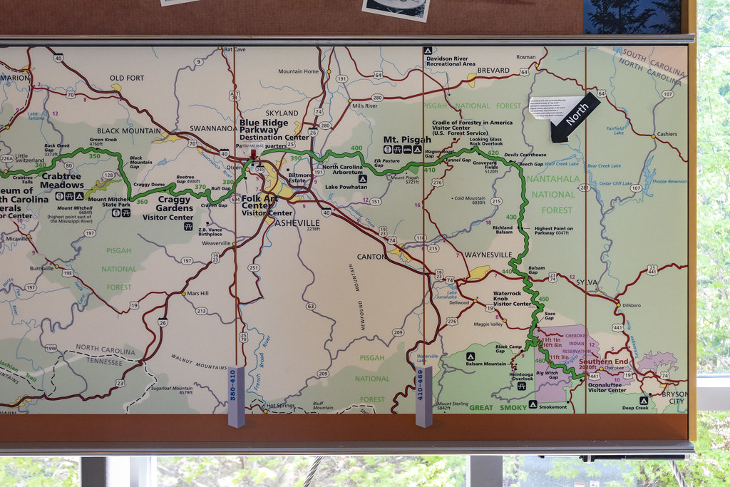
The green line is the BRP. The small portion we drove on May 1st is from Cherokee (at bottom right) to Ashville (basically where it says Folk Art Center a little left of center on the map).
The entire 469 mile long Blue Ridge Parkway from Shenandoah National Park to Smoky Mountain National Park. We drove a little over 1/2 of the length in 3 days of about 90 miles a day.
Couldn’t resist a pic of this pic. Not sure if the guy in boots and stubby tie is an Engineer or a Landscape Architect. Whoever he is it looks like he’s trying to impress the photographer. I am impressed by the stone masons building the nearly flat arch in the background!
Another pic of a pic. We will be driving on this Linn Cove Viaduct tomorrow (but without the fall colors or the helicopter view).
This orange flowering azalea is the only photo I have from the Folk Art Center. No photography is allowed. There were so many things I wanted to take photos of to remember! Alas, they would prefer we purchase them but that would require winning the lottery.
The Folk Art Center is incredible. It is home to the Southern Highland Craft Guild. The woodworking, quilting, textiles, carving, wheat weaving, pottery, etc., etc. is mind-blowing, beautiful, best-of-the-best stuff. This is a “must visit” place. I was thinking that visiting Biltmore was the most impressive thing to do in Asheville. The Folk Art Center may top that.
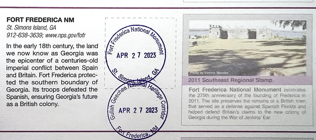
Sad to leave Jekyll Island but now we can look forward to next year. We headed north to Santee but on the way took a trip across the bridge to St. Simon Island and the National Monument at Fort Frederica.
So much history of southern states that was not in our northern textbooks. Lexington, Boston, Paul Revere, we heard about those. I also got the Gullah Geechee stamp because the coastal areas are where the Gullah and the Geechee developed their own subcultures and languages. I need to learn more about them.
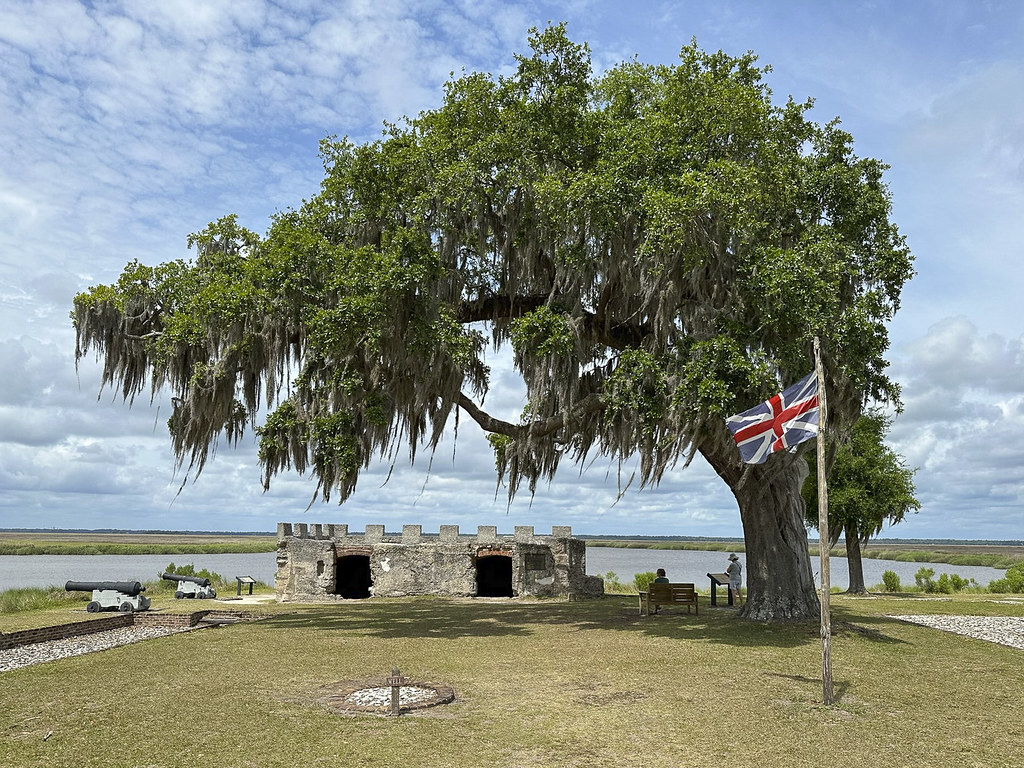
The remains of Fort Frederica. Love the British flag and brooding live oak tree. Easy to imagine troops guarding the “debatable lands” between South Carolina and Florida, against those pesky Spanish in Florida. The cannons guard the Frederica River. Frederica, the town and river got it’s name from Frederick Louis, the Prince of Wales. This remaining fort seems tiny but at the time (1736) it was the strongest fort built by the British in North America. Not seen in this photo is the entire colonial town behind the fort that supported the troops and townspeople. The entire town was enclosed in a palisade wall and raised earthen embattlements with a dry ‘moat’ to repel attack by land.
I was eager to go to Fort Frederica to; 1. Get the stamp for my National Parks Passport book, 2. Learn about history I missed, 3. Visit a place called Frederica… my great grandmother’s name was Esther Frederica Albertina Zigler Dart. I don’t know why that seems like a connection but it’s something…
Plaque mounted on the fort wall. Horton (who settled on the neighboring Jekyll Island) sailed with Oglethorpe.
What’s left of the mounded “Town Wall” is directly in front on this photo. The Town would be to the right and the “dry moat” is to the left.
One last massive spreading live oak tree with Spanish moss before we leave the warm coast and head back inland toward home.
From Fort Frederica we headed due north to Santee Lakes KOA. We didn’t know it but leaving Jekyll Island let us avoid a big rain they got that night. We had a little rain but nothing like the downpour they got.
View of the beach and dock from our campsite. They described this as “on a bluff overlooking the lake”. I guess when you are close to sea level even a few extra feet of elevation qualifies as a bluff.
That’s our RV, up on “the bluff”. This KOA could be nice, but it’s way overpriced and pretty run down. We won’t return but at the time we were making reservations all the State Parks were full. It turned out to be an ok place to sit and read. Becky got a bunch of quilt blocks sewn and I got the four days at Jekyll Island post done.
1. Three Rivers State Park – on Lake Seminole, which is formed by the convergence of the Chattahoochee and Flint rivers.
2. Suwanee River State Park – is THE “Swanee River” of the “Way Down Upon Swanee River…” minstrel song by Stephen Foster in 1851 (also known as “Old Folks at Home”). My dad used to sing that song all the time on family vacations. It has been stuck in head now for about a week.
Taken from the dock at Three Rivers State Park, Florida. That’s Georgia in the fog on the other side of the river.
Not much to photograph at Three Rivers State Park. If you are a fisherman it would be a great place to hang out. Otherwise there’s not much to do here. The trees in the area where decimated by Hurricane Michael in 2018. This is a small campground and the long ‘asphalt’ road back to the campground looked like it had been carpet bombed. Very slow going dodging potholes. We stayed here because Florida cancelled our reservations at Falling Waters State Park. We were happy to move on to Suwannee River State Park.
Suwannee River State Park was a big improvement over Three Rivers. This panorama is of the Suwannee (which is flowing from right to left) at the point where the Withlacoochee River joins with the Suwannee. There is a railroad bridge at the very left of the photo. The railroad bridge and a busy ferry crossing at this strategic location during the Civil War caused an interesting historical feature of the park.
The remains of the Civil War Earthworks. An earthen “fort” is still easy to imagine.
Gears from old paddleboat and old paddleboat “wheel”
Clear water from Little Gem Spring flows into the Suwannee. Hiking a trail along the river sure is a lot different in Florida than it is in Indiana…
River edge of the Suwannee. As the water gets deeper it turns orange, then red, than dark coffee colored from lots of tannins in the water.
Becky got out her sewing machine and knocked out some quilt blocks
Rich Reflections
Cyprus Knees. This is probably boring stuff to Southern folk; but fascinating to Indiana folk.
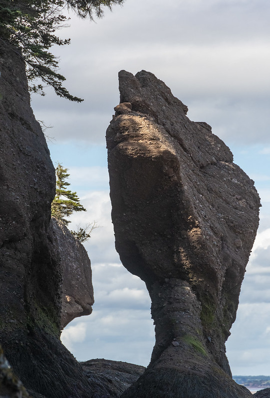
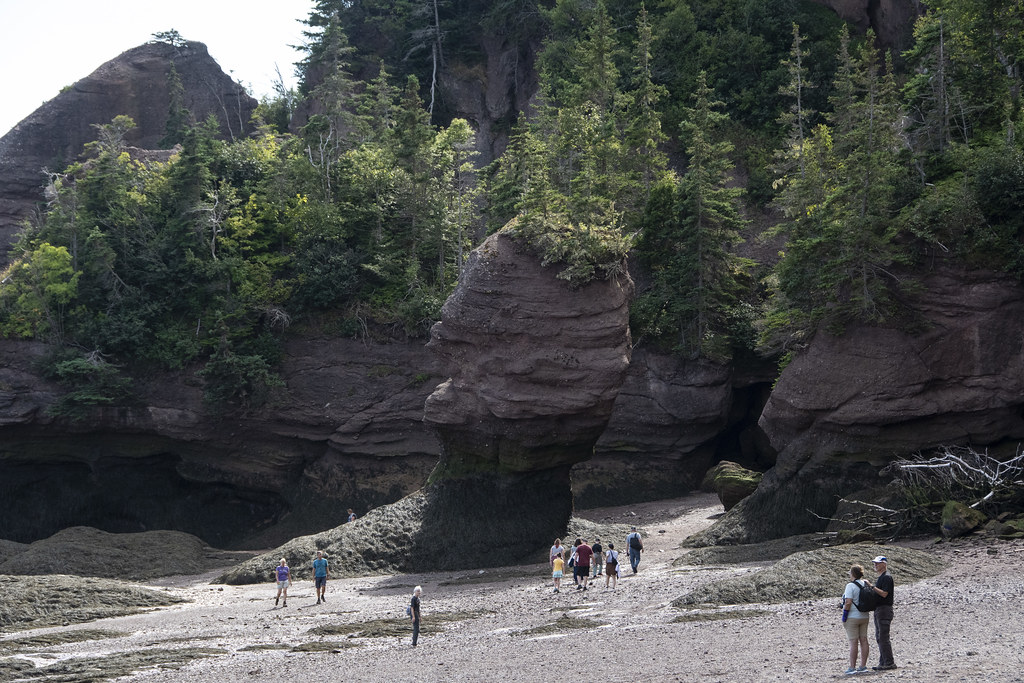
These are sometimes called “Flowerpot Rocks” or “Sea Stacks”. We arrived at Hopewell Rocks on an afternoon when the tide was in (up). After spending the night nearby we returned again in the morning when the tide was out. Tides vary daily but there can be as much as a 52′ difference in the water level from tides in the Bay of Fundy area.
View from our campsite – there were more than a few mosquitoes here
Flowers at Hopewell Rocks and at entrance to our campground
Tide IN
Tide OUT (mostly, this was not full lowest tide)
It’s an odd feeling walking around where you know in a few hours the tide will come back and submerge everything. This happens twice a day (in/out, in/out every 24hrs) so it’s relatively rapid; you can stand and watch the water level change.
Jennie & Roni
Me
When the tide is out, it is Way Out
Kayakers heading out as the tide comes in far enough to float them
That’s all the photos for this trip. We went from Hopewell Rocks to St. John, New Brunswick for the tour “dismount” festivities. However, more than a few of the group had Covid at that point so we said our goodbyes and headed for home.
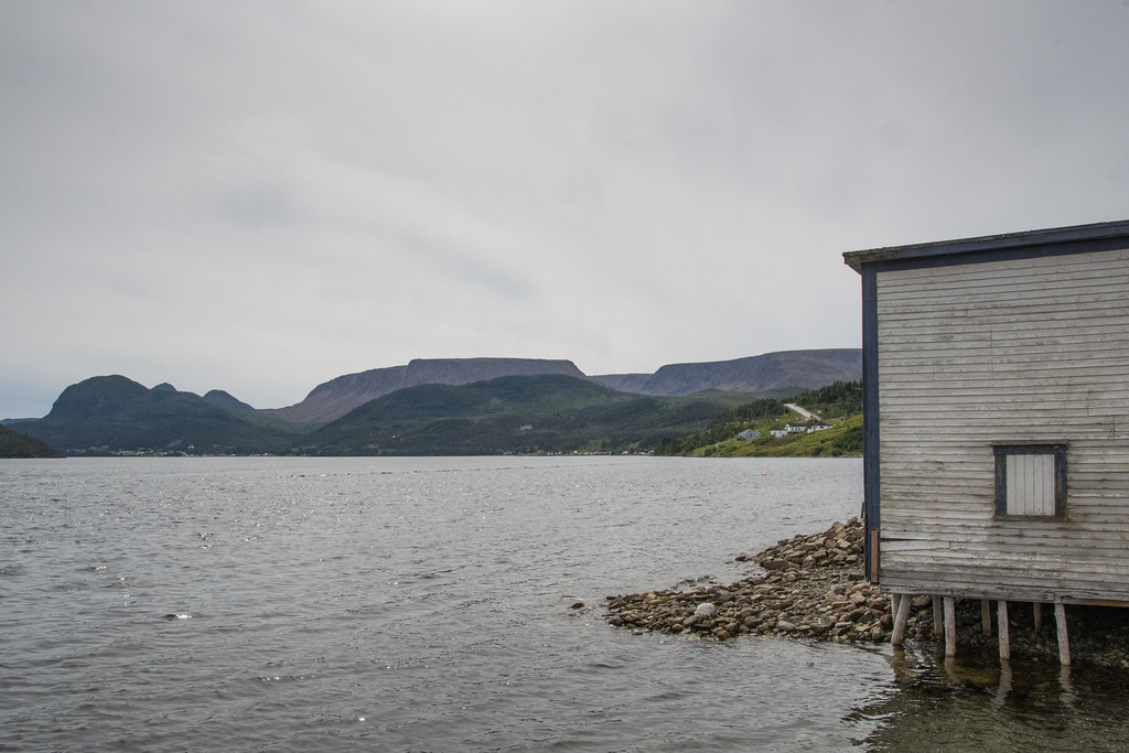
On our last day in Gros Morne National Park we visited the town of Norris Point and we drove around the East and South “Arms” of Bonne Bay to the towns of Bonne Bay and Woody Point. The photo below is from a little roadside gift shop along the way to Norris Point. The foreground is a hedge of rose hips, Bonne Bay in the middle and Tablelands in the background.
A kinetic whirligig sculpture commissioned in 1997 for Gros Morne National Park as part of the Canada 150 Celebration. It is located at the same gift shop. Sculpture originally had movement but tough Newfoundland weather has taken it’s toll… Scenes of local nature, including giant mosquitoes.
The Bakery: We were told there was a bakery we should not miss in Norris Point. We found the bakery and got some fresh rolls. It is the most “Newfoundland’ish” store. This homemade sign hung above the checkout counter. It’s not a joke. It’s just an honest declaration of business hours in the local way of speaking. The place to visit is “C&J Rumbolt Ltd”. It doesn’t look like much on the outside. Go in the door that says “Rumbolt’s Bakery”, you won’t be disappointed. Surprised maybe, but not disappointed.
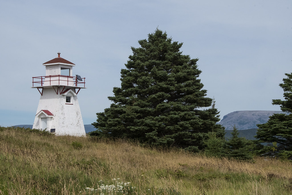
Woody Point Lighthouse
There is a Discovery Center at Woody Point. We learned throughout the trip that Moose Nose was a “thing” to eat in Nova Scotia and Newfoundland. Early settlers in Acadia ate Moose Nose Soup. I was happy to find a recipe at the Discovery Center on how to prepare a moose’s nose for a special family dinner.
Moose were common and natural on the mainland in Nova Scotia but were never on the island of Newfoundland until brought there around 1900. With no natural predators they have flourished and now outnumber the people of Newfoundland.
Above and Below: Gros Morne Mountain towers over all the local landscape.
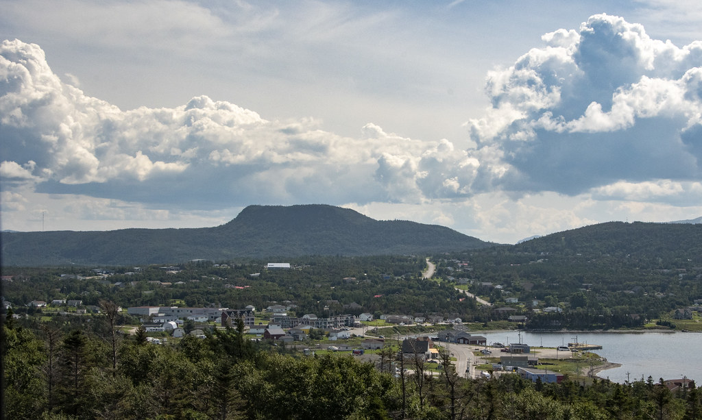
Gros Morne looming behind the town of Rocky Harbor
Gros Morne from Lobster Cove Head Lighthouse
That’s it for Gros Morne National Park. If you get a chance to visit this awesome place, plan to spend at least a week here.
Our last night “on the rock” of Newfoundland we traveled to a campground near the ferry at Grand Codroy. The following morning we loaded back up on the ferry at Port aux Basque for the much shorter (5 hours) trip back to North Sydney, Nova Scotia.
While at Grand Codroy I tried some sketching and painting of the lighthouse we had seen at the beginning of our trip (Portland Head Light, Fort Williams Park, Maine)
A beaver, dragging a branch of pine tree upstream
A parting sunset over the Grand Codroy River for our last night in Newfoundland
We stayed in St. Anthony several nights. This was the place “farthest from home” of the trip. It is 2,271 miles from Indianapolis.
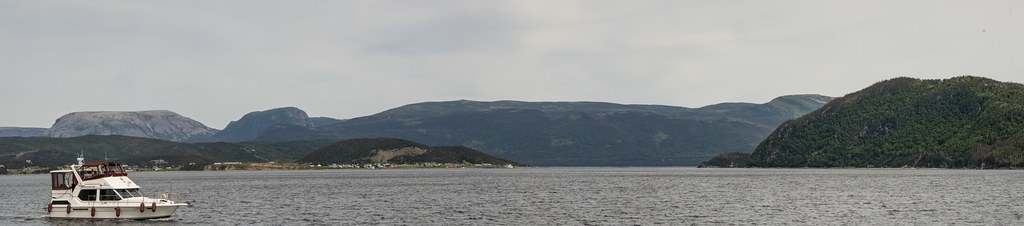
That’s Newfoundland coast in the foreground, and Labrador over on the other side. We traveled from Gros Morne National Park, up the western coast of Newfoundland to St. Anthony which is out near the northern tip of the island. The picture above was taken where Newfoundland and Labrador are closest together across the Strait of Belle Isle in the Gulf of St Lawrence – a distance of about 10 miles at it’s narrowest.
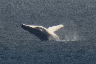
We took a boat tour to find a whale. It was a windy day and not a very big boat… it reminded me of the infamous “Minnow” as we headed out for a 3hr tour… hoping we would not be lost.
Thanks to our persistently searching Captain, and our fearless crew, we did see whales! The boat was bobbing wildly on the waves and this was a lucky shot.
Rugged Coast
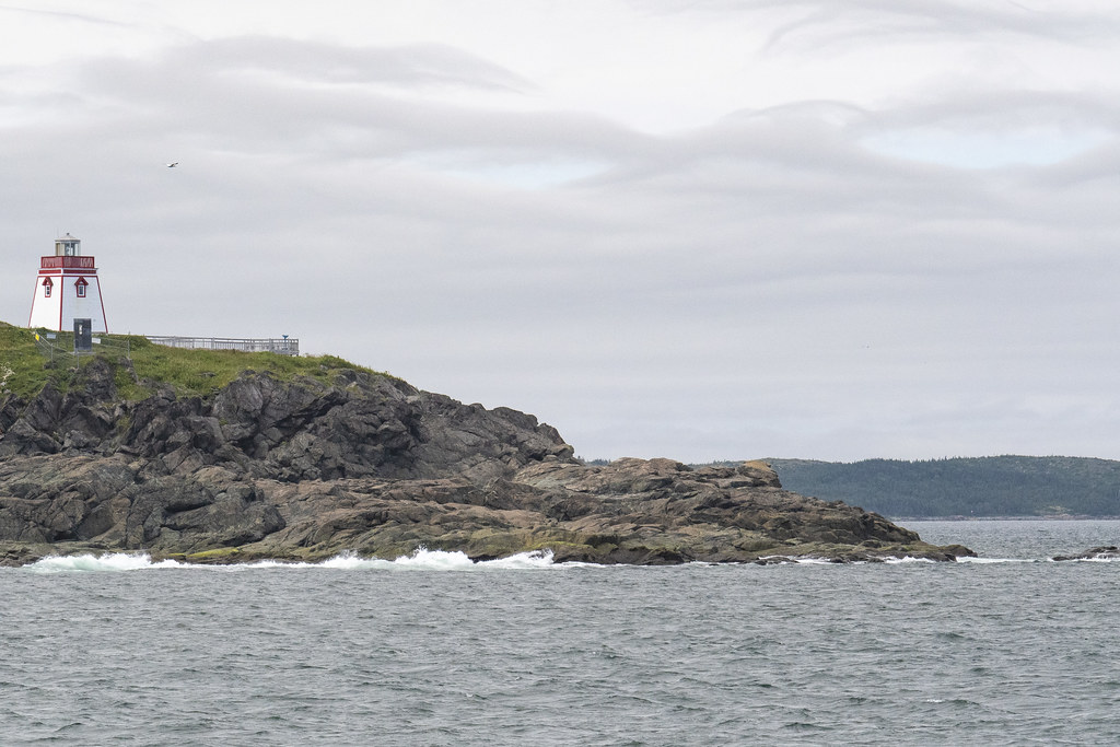
Fox Point Lighthouse as we were returning back to dock at Northland Discovery Iceberg & Whale Tours.
Above: Fox Point Lighthouse and “Haul Up Cove”. There is a wonderful little restaurant near the lighthouse called “Lightkeepers Seafood”. We hung out there several times. We enjoyed the food and the Wi-Fi (which is hard to find in Newfoundland). There is also a nearby thing called the “Great Viking Feast”. We recommend avoiding that.
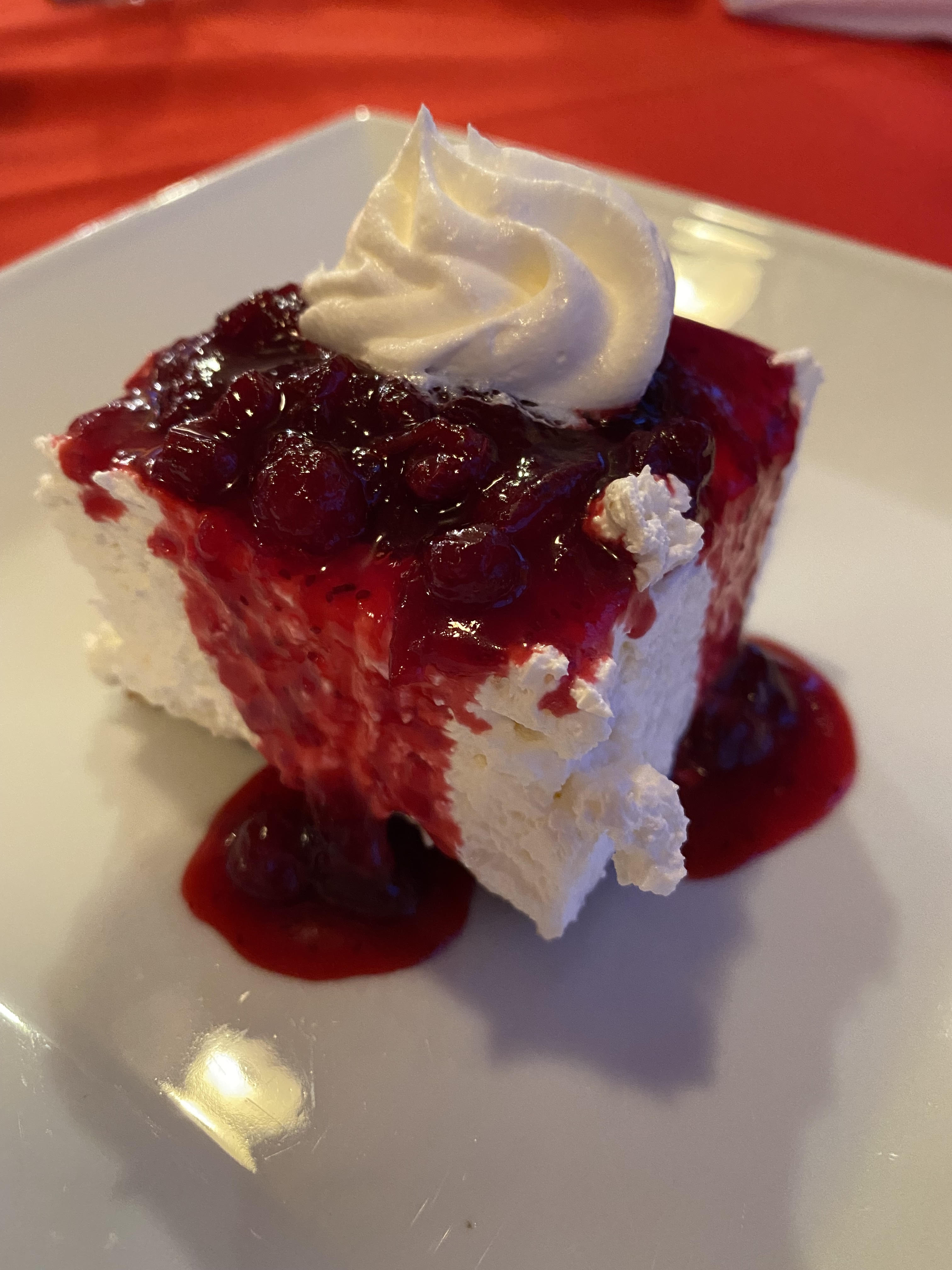
Above: Partridgeberry Cheesecake: Lightkeepers Seafood Restaurant. Trivia: Partridgeberry picking season was in full swing. Partridgeberries are the same as what other countries call “Lingonberries”. They are a relative of the cranberry but more mild. In Newfoundland, they grow in a low evergreen shrub in the dry acidic soils of Newfoundland and Labrador’s coastal barrens and headlands. Newfoundland and Labrador are the largest harvester of Partridge/Lingonberries in North America.
Fried Cod Tongue. I thought it was delicious. Didn’t get much help from the rest of the group. It is considered a Newfoundland delicacy. Also at Lightkeepers Seafood Restaurant. We really enjoyed this restaurant. We really did not enjoy the Great Viking Feast.
Below: Scenes from around the boat dock.
Above: Green coastal rocks
Below: Really far out from shore the whales were jumping way out of the water-looked like they were having a great time. These were taken from the little front porch of the Lightkeepers Seafood Restaurant where lots of visitors stood watching the whales play.
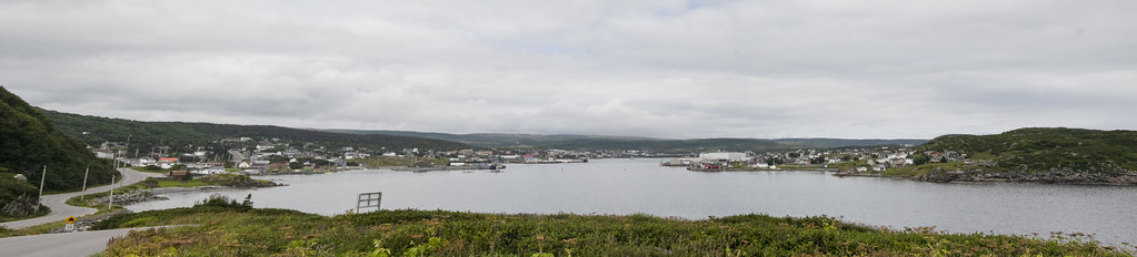
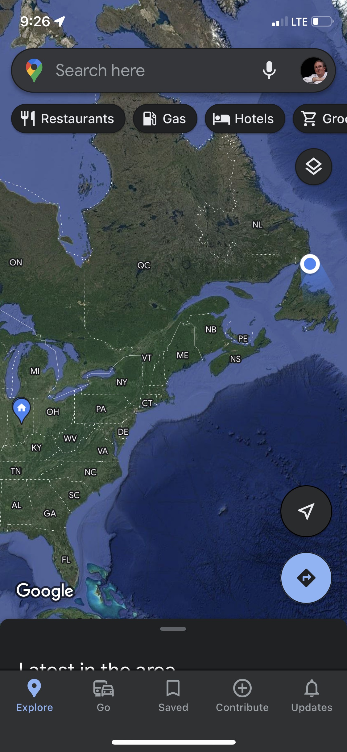
Panorama from Fox Point area looking back at town of St Anthony and Marguerite BayScreenshot of Google Maps location. 2,282 driving/ferry miles from home to L’Anse aux Meadows National Historic Site at the very northern tip of the peninsula was the next days visit.
Sometimes there is time to kill on travel days because you cannot arrive at the next destination until late afternoon.
We stopped at “The Newfoundland Insectarium” while traveling from Twillingate to our next stop at Gros Morne National Park.
It’s a nice insect collection but it could be anywhere, not particularly Newfoundland’ish. I enjoyed the live exhibits more than the dead ones. I don’t have a photo but it was fun watching a whole bunch of live leaf-cutter ants carry leaves around.
Another stop was at: “Salmonid Interpretation Centre” on the Exploits River near Grand Falls. This is the fish ladder bypass
This is looking below the falls and fish ladder
The fish ladders lets the fish (salmon) go up the gentle ladder instead of this set of treacherous rocky falls
Whale spouting (that little bit of mist in center)
Bad photo of a Whale’s Tale (but proof we saw them)
Panoramic view from Long’s Point Lighthouse
Newfoundland Scenes around Twillingate
We chartered a boat from “Captain Dave’s Boat Tours” and went Cod “fishing” (really “jigging”). Those are whale bones! Captain Dave himself skippered the boat (David Boyd). His family history is closely linked to Cod fishing and he is passionate to pass along the history.
Jellyfish at Captain Dave’s. Captain Dave’s is also the location of “Prime Birth Twillingate Fishery & Heritage Centre” which has an interesting museum of all things fishing…
Whale Baleen
This gentleman cleaned all the Cod for us
That bucket of gook is full of Cod Liver Oil. He was very good at fileting fish. Glad I didn’t have to do it.
We saw coastal scenes of rocks and seabirds while getting out to where we fished
We caught lots of Cod and one iridescently colored Mackerel
Twillingate was one of our favorite stops. The RV Park was on North Twillingate Island. It was an easy walk from the RV Park to the water at “Back Harbor”. Back Harbor faced west so we saw some beautiful sunsets. Back Harbor had the ubiquitous and iconic brightly colored “fishing rooms” around the harbor.
Twillingate is called “The Iceberg Capital of the World” because icebergs drift south on ocean currents from Greenland and Labrador. They often get “stuck” around Twillingate when their bottoms hit the shallower bays. We were too late in the summer to see icebergs (but we did see Humpback Whales). This post is about the area where we were camped. The next page will be about places nearby we traveled to on day trips.
Trivia: Twillingate residents must use extra caution in the spring because Polar Bears and Seals often arrive on the icebergs! Here is a link to a beautiful blog about Newfoundland: Seasons, Icebergs, Capelin, Whales, and Berries: https://newfoundsander.wordpress.com/icebergs/.
Sunset from Back Harbor, North Twillingate Island. I would walk over with morning coffee, sit and enjoy peacefulness
Roni & Becky watching me climb up the hill to get a panoramic picture of Back Harbor Bay.
Lupin
Berries. Not sure what these are but there are low growing “bushes” (maybe 6″ high) growing all along the coastal areas. Blueberries were ripening when we were there. We had handfuls of fresh blueberries on several days.Blueberries – Newfoundland Style. Not like the big bushes in Indiana at all.
Rock with section of purple stone (possibly purple quartz?)
Lobster Traps, waiting for next season
Salt Box Home we walked past each day from RV Park to Back Harbor Bay.
I don’t have a photo but it’s worth mentioning the “Split Peas” at “Twillingate-New World Island Dinner Theatre”. The local ‘actors’ and fantastic musicians put on a hilarious show of all things Newfoundland’ish. We enjoyed it, the food was good too. https://vacationintheisles.com/dinnertheatre/
We’ll end this post with more sunset pics – We didn’t want to leave Twillingate…
Cape Spear is the ‘easternmost’ point of land in North America. The sun comes up here long before it comes up at the much advertised Acadia National Park, Cadillac Mountain, Maine. It’s difficult to tell how much earlier because Newfoundland is in a different time zone 1-1/2 hours earlier than “Eastern Time”. Most of Canadian Maritime Provinces are 1 hour earlier than Eastern but Newfoundland gets another 1/2 hour earlier.
The Original (now inactive) Cape Spear Lighthouse – 1836
For a sense of scale; this photo is taken from Cape Spear, looking back northwest toward the St. John’s Harbor entrance. That bump on top of Signal Hill is Cabot Tower and the white dot below and left of the tower is the Amherst Lighthouse.
Above: Clear water and rugged coastline. Locals told us this was one of the most calm Atlantic waters they had ever seen. Below: The nearby “New” (active) Cape Spear Lighthouse was built in 1955.
Looking Down: I enjoyed sitting on the edge of the easternmost cliff of North America. It was a long, long, long, way down and very windy but the breeze was blowing UP the cliff. It was fun to watch seabirds flying along below. Photos just don’t begin to capture the feeling of being there.
Pointe-Au-Pere Lighthouse. This was our first stop on a ‘travel day’ from Quebec City to the town of Perce and Bonaventure Island (on the very eastern tip of the Gaspe Peninsula). July, 2022
Interesting rocks in this area. Many were thinly layered and brittle/crumbling.
Others rocks were smooth and wonderfully patterned – like an expensive pillowcase
Genesis 28:11 describes Jacob using a rock for a pillow. This would have been a great one…
Canadians love their lighthouses. They even build little roadside models of them. Here Jenni & Roni, pose with a model of the lighthouse we will see at our next stop (along the way to Bonaventure Island at Perce).
(Also called Gaspe & Atlantic Provinces by Adventure Caravans).
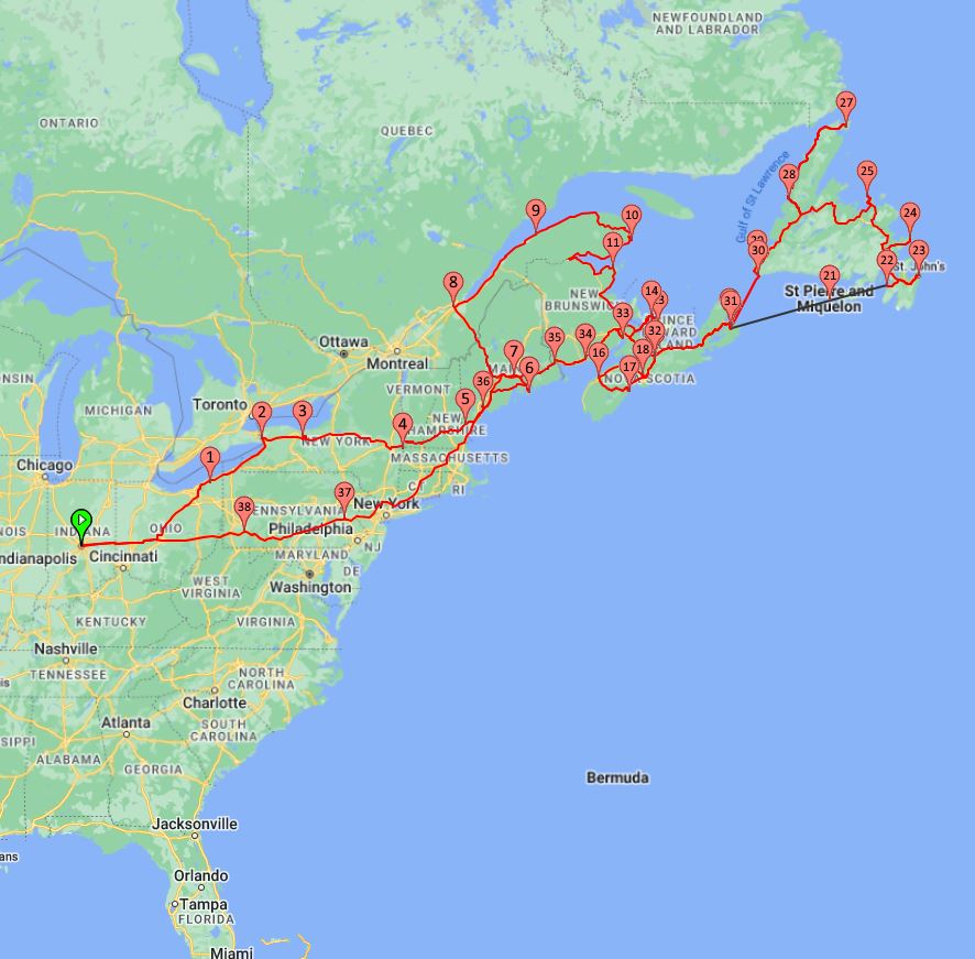
In June of 2022, two months after retiring from Schmidt Associates; Becky and I set out on a two month adventure. We took the RV 6,434 miles, over 71 days, from June 19 – August 29, 2022.
We (Duane & Becky) traveled in our 2021 Thor Axis 24.1 RV and Becky’s sister and her partner (Jennie & Roni) traveled in their Winnebago View V RV. We met-up in Indianapolis and traveled together to Niagara Falls and Acadia National Park before joining up with an Adventure Caravan group at “The Pumpkin Patch RV Resort” in Hermon, Maine (near Bangor). There we met a bunch of new friends for 2 months (the 59 day tour package was called “Gaspé & The Atlantic Provinces“. After introductions and a few days prep at “The Pumpkin Patch” we headed north for our first stop; Quebec City.
Map above: the first month’s travels on “the Mainland”
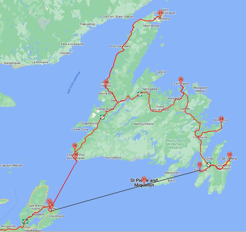
Map Above: the second month’s travels “on the rock” in Newfoundland. The straight black line isn’t accurate because the actual route the ferry took from North Sydney, Nova Scotia to Argentia, Newfoundland; curves south under St. Pierre and Miquelon but I couldn’t get it to map the curved ferry route.
There is basically one main road in Newfoundland; The Trans-Canada Highway (1). It goes from Port aux Basques to St. Johns. The road north on the “Great Northern Peninsula” to St. Anthony is called “The Viking Trail”, Route 430.
We saw this sign all over Newfoundland. They have terrible roads and they own it. We saw LOTS of potholes. They also haven’t figured out how to transition from a road surface to a bridge surface; anytime there was a bridge we learned to slow way down because there was usually a ledge either up or down at the transition.
We also saw lots of “Beware of Moose” type signs. There are supposedly more moose than people in Newfoundland. We looked for a month and never saw one…
If you want to keep going with posts in chronological order, scroll down a bit until you see Niagara Falls, Buffalo, NY → click that and following “right arrows” to keep going →