13 of 22 – 2024 Fall Trip West Series. 10/1/24 Tuesday. We did a big road trip today to: Valley of Fire State Park, Hoover Dam, and Lake Mead. Valley of Fire State Park seems like it should be a National Park because it is huge and there is so much to see there.
In 2012, a rough road called the Arrowhead Trail was first built in this red rocky area to travel between Salt Lake City and Los Angeles. In the 20’s it became known as the Valley of Fire when a AAA official driving through at sunset said it looked like the entire valley was “on fire”.
We went for a short hike in the “White Domes” area. It was very hot and hard to walk in the soft sand.
Hoover Dam National Historic Landmark
Lake Mead was created by Hoover Dam. It is the largest water reservoir in the United States. The water level has been going down for many years and it currently holds less than 30% of the amount that Hoover Dam was designed for.It is a strange thing to see a big body of water in the middle of hot treeless desert.
12 of 22 – 2024 Fall Trip West Series. 9/29/24 Sunday. On our last day staying at Panguitch we visited Cedar Breaks National Monument. At over 10,000′ elevation this was the highest place we drove to (the Pikes Peak Cog Rail Train took us to over 14,000′). The scenery on the drive was spectacular with aspens in full yellow glory.
On the way we saw these young Pronghorns. I don’t think any of us had seen these before so we had to look them up to figure out what they were. Trivia: They are not antelopes or even related to them although sometimes they are called pronghorn antelopes. They are the fastest mammals in the Americas and can run 55 mph for long distances. Cheetahs are the only thing faster but for only short distances.
Cedar Breaks is a giant eroded amphitheater shaped wonderland. It is 3 miles wide and 2,000′ deep. Geologically it is at the very top height of “The Grand Staircase”. Cedar Breaks was not on the trip plan but Jennie suggested it. Not knowing anything about it made this unexpected view at the first overlook a very dramatic surprise!
Our group who traveled together from Kansas. This was our last group photo as Jennie and Roni would head back home tomorrow.
The photos just look so small. It’s sad they can’t convey the awesome magnitude of the scale and majesty of this place…
Leaving Cedar Breaks National Monument we headed down the mountain to Cedar City to get gas and find some place to eat. We had used a lot of gas getting up the mountain to Cedar Breaks and the warning light was on when we headed down. We coasted downhill so much that by the time we got to the gas station we had more ‘miles to empty’ than when we started down.
Last photo of our drive back to camp from visiting Cedar Breaks. Sorry to leave this beautiful part of the country behind as we travel to the more treeless desert of Zion tomorrow.
Becky’s Birthday flowers traveled in the RV sink on the next day’s drive from Panguitch to Hurricane.
The RV and rental car when we arrived in Hurricane, UT at the very nice WillowWind RV Park. We stayed here 5 nights.
11 of 22 – 2024 Fall Trip West Series. 9/28/24 Saturday. Deanne and I got up early and drove back to Bryce Canyon to hike “Wall Street”. The trail is 3.2 miles long. The descending Wall Street portion is part of the Navaho Loop Trail and the ascending portion is called Queen’s Garden.
Wall Street starts down from Sunrise Point Overlook. All pics of this hike are from our iPhones. I figured I could get down the trail but getting back up to the rim would be challenge enough without lugging the big camera.
The view from Sunrise Point.Deanne took this picture of me the day before when we checked out the top of Wall Street and decided to come back to hike it.
Starting the Wall Street hike, looking down the switchback trail.
Deanne heading down the trail. Me with Nathan’s borrowed hiking poles. They helped a lot.
Nearing the end of the initial switchbacks there is a narrow opening into a deep slot canyon.
Turning around and looking back up the canyon from the slot.
First sight of the Douglas Fir trees growing tall in the narrow canyon.
Taking a break on the way back up the Queen’s Garden trail. It was starting to get pretty warm and I was getting pretty worn out but the views down in the canyon were beautiful and I was determined to finish this.
View looking out and up from where we were resting.
Beautiful wildness.
The trail was similar to this much of the way
Deanne got to the top first.
All smiles, not even tired.
We did it! That completes the Wall Street hike. After taking a break at the park store we gingerly levered ourselves back into the car for the drive back to Panguitch. We stopped for a few pictures of Red Canyon on the way back.
The red rocks of Red Canyon. Trivia: Near this location is The Butch Cassidy Draw, a trail used by none other than famous outlaw Butch Cassidy (real name Robert Leroy Parker). Much of the film Butch Cassidy and the Sundance Kid was filmed here in Red Canyon. On our way to Panguitch we had driven past the childhood home of Butch Cassidy which is alongside Highway 89. We didn’t stop then but after we learned of his childhood in the area I wish we had.
10 of 16 – 2024 Fall Trip West Series. 9/27/24 Friday. A beautiful day to visit the otherworldly Bryce Canyon NP.
Panguitch; a Paiute Indian word meaning “big fish” how do you pronounce that town name? Not Pan-gu-itch. Think of “Penguin Sandwich,” that’s how we were instructed by the owners of Dixie Forest RV Resort where we were staying; “Peng-wich”. The elevation at Panguitch is 6,666′. The elevation at the rim of Bryce Canyon is 8,500-9,000′
Beautiful fall colors at the Bryce Canyon “Natural Bridge” overlook.
Beautiful drive to many outlooks along the canyon rim.
Golden Aspen fall colors.
Deanne conversing with the raven.
Two pics above are both of the “Wall Street” canyon. The left is the top of the canyon, the right is looking down into the top of the canyon with lots of hikers on the trail. It was mid-day hot today so we decided to come back early tomorrow morning to hike “Wall Street”.
One last photo of the incredible Bryce Canyon before we headed down from the rim to Kodachrome Basin State Park.
View driving into Kodachrome Basin State Park.
Some wind spinners we saw along the road. The cliffs in the far background are Bryce Canyon.
Real cowboy ranchers on horseback were herding cattle down the road.
Becky’s Birthday came while we were at Panguitch. Flowers and M&M’s brightened up our campsite.
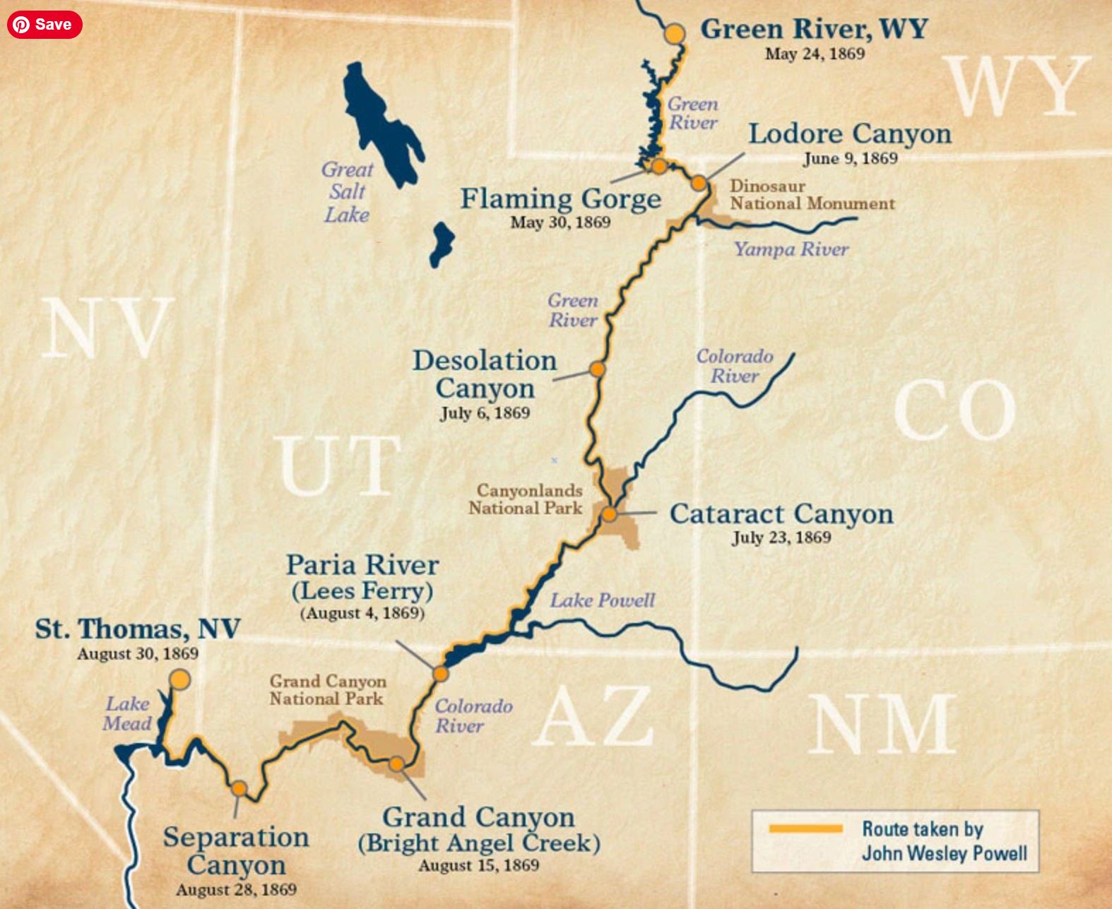
9 of 16 – 2024 Fall Trip West Series. 9/26/24 Thursday. We traveled from Moab to Panguitch, UT. We stopped at the John Wesley Powell Museum in Green River, UT, and we stopped at Capital Reef National Park. The museum was not on our agenda when planning the trip but Deanne had read about it and wanted to stop. We are glad we did.
Route of Powell’s first expedition in 1869. We would travel on to look down into Cataract Canyon in Canyonlands National Park, Lake Powell, Grand Canyon, and Lake Mead on our trip.
Crazy that little wooden boats would tackle raging rapids. Boat above is a replica of one of the boats lost at “Disaster Falls” on Major John Wesley Powell’s first trip down the Green/Colorado rivers in 1869. Disaster Falls is in “Ladore Canyon” in the map above. The original boats looked like a cross between a canoe and a rowboat. Deanne studying Colorado River lore.
Deanne activated this character when she walked up.
These are some improved versions of boats made to better maneuver and withstand the stresses of running whitewater river rapids. The look less like rowboats.
Dramatic sculpture in the museum. The Colorado River had a lot more water before flood control dams and irrigation. Powell and his team were brave explorers.
Loads of fossils are found in the area including these fearsome dinosaurs. I am glad they are gone.
I don’t remember where this is. There is a lot of desert between Moab and Panguitch. I thought the individual standing stones were cool. This may be somewhere near Goblin State Park which we drove past but did not stop at.
Our tiny RV parked along the road is dwarfed by “The Castle” landform on the left and “The Rim” on the right. This is near the Visitors Center. Capital Reef National Park was basically a “drive-thru” park. There was a lot of road and infrastructure construction going on and just about everything we hoped to see was closed. We enjoyed the things we could see on the main drive through the park, got the NPS Stamp, and moved on a bit disappointed.
The Castle.
We stayed for 4 nights in Panguitch at Dixie Forest RV Resort. Lots of stars on a clear night.
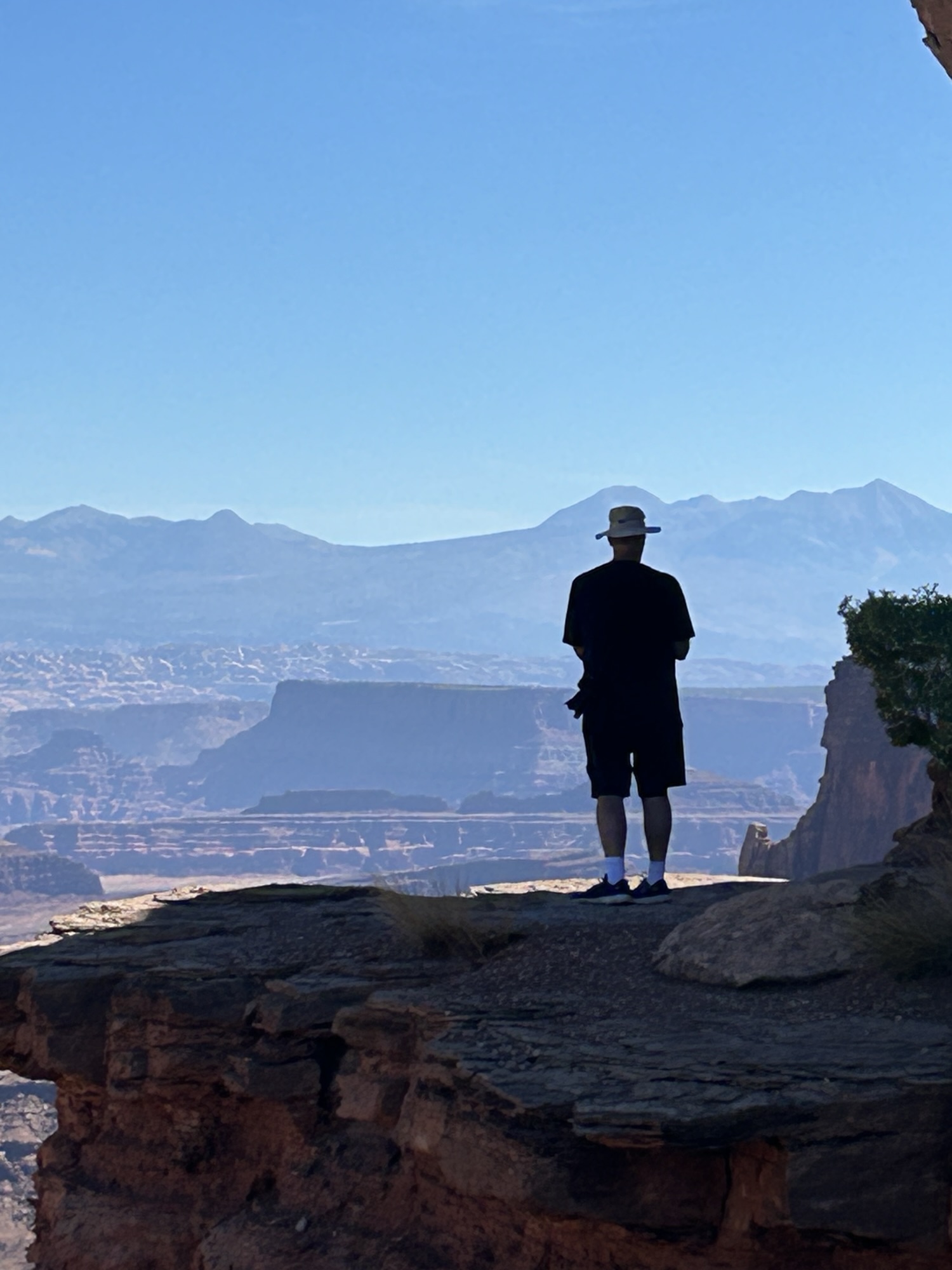
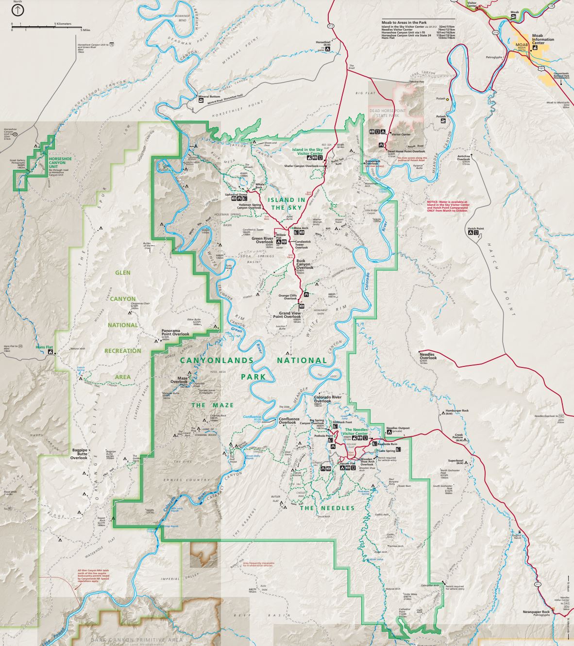
7 of 12 – 2024 Fall Trip West Series. Canyonlands National Park “Island in the Sky” and Dead Horse Point State Park. The “Island in the Sky” name refers to the 2,000′ high mesa the entire area is on (compared to the river valley floor below).
The Merrimack and Monitor: a pair of buttes named after the Civil War ironclad ships USS Merrimack and USS Monitor.
The road zigzagging down to the Colorado River Valley District in this photo is called The Shafer Trail. It’s a 19 mile long 4WD dirt road. The Shafer Trail road also shows up in the first photo of this post. It was originally a route made by Native Americans, then named after a 1916 era Mormon Settler “Sog Shafer” who improved it. The it was further improved and widened for large trucks bearing uranium rock by the Atomic Energy Commission. After Canyonlands became a National Park in 1964 it transitioned to today’s backcountry recreation trail. I couldn’t convince anyone to try it.
Layers upon layers upon layers.
Arches National Park has lots of Arches but Canyonlands has some too. This one is the famous Mesa Arch.
An Island in the Sky.
View from the overlook at Dead Horse Point State Park.
Sweeping views across canyon from Dead Horse Point State Park.
6 of 12 – 2024 Fall Trip West Series. Monday 9/23/24. Canyonlands National Park is Huge. There are two distinct entrances to north and south sections that are completely disconnected by the deep canyons of the Colorado and Green Rivers.
Today we left Moab to visit the southern “Needles” section of the park. A park ranger at Arches highly recommended we visit the “Needles Overlook.” She said “not many people go there because it’s out of the way but it’s worth the drive. You’ll be the only ones there in the morning.” It really is a long, lonely drive, we almost turned around but eventually arrived at an incredible view of why the two halves of the park are not connected.
Leaving the Needles Overlook we went further south and entered “The Needles” section of Canyonlands National Park. The day was filled with all kinds of awesome and unique rock formations.
Leaving “The Needles” we headed north back to Moab stopping at a roadside attraction: Wilson Arch.
After leaving interstate 70 to head south down to Moab the wind picked up and a rain storm blew in. Deanne and Becky were in the rental car. I was driving the RV and trying to stay in my lane when the wind gusted sideways. Fortunately there was not much traffic on the road.
Next morning we headed into Arches National Park with our park visit reservations in hand. First stop, the Visitors Center for restrooms and gift shop.
Becky was delighted when her sisters got her this quilt pattern for a small wall hanging of Delicate Arch. This is a picture of a sample finished product.
Rock cliffs glowing red in the early morning sunshine.
Our first hike on the “Devils Garden Trail” started out chilly and got pretty warm by the time we got done. The trail goes to several scenic sites but the main goal is the thin “Landscape Arch”.
Landscape Arch.
Our next hike was to Skyline Arch Trail. Jennie & Roni at Skyline Arch.
Sand Dune Arch Trail was next. Becky and Deanne navigate a narrow passage.
Delicate Arch Trail was longer and it was getting really hot so we didn’t go all the way to the Arch.
Balanced Rock.
Very tiny, in the center of this photo in the far distance are “The Three Gossips” which was our next stop. The Three Gossips are a 350′ high sandstone rock formation resembling 3 heads in conversation.
The Three Gossips.Duane taking pics. Photo by Deanne.
We went out to dinner in Moab after a long day of hiking and driving through Arches National Park. The onion rings were a big hit.
4 of 12 – 2024 Fall Trip West Series. While at Glenwood Springs, CO for two nights Deanne rented a car that we all would use for our visits to National Parks in Utah, and we visited the Colorado National Monument.
On our travel from Florissant Fossil Beds National Park to Glenwood Springs we saw some beautiful fall colors as the aspens turned bright yellow.
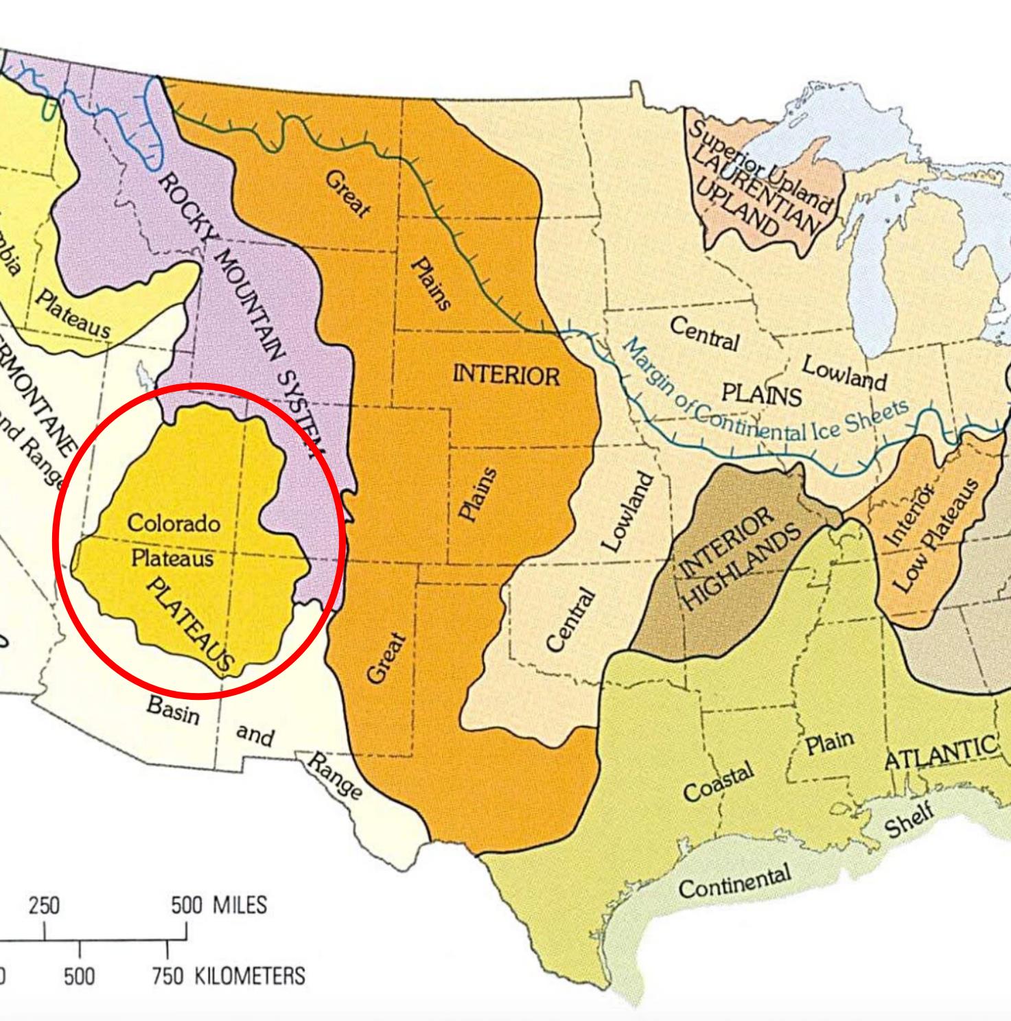
Below is a map of “US Terrain Regions” as mapped by the US Geological Survey. When we left Indianapolis in the Central Lowland Plains, traveling west through the Great Plains, then crossing the Rocky Mountain System, we arrived at the Colorado Plateau(s). I thought we were just headed to a bunch of National Parks in the Utah vicinity. I had no idea there was a name for this densely packed geological wonderland called “The Colorado Plateau”
The Colorado Plateau – “the least tamed area of the lower 48 states.” The Colorado National Monument was the first of many National Parks all included in the Colorado Plateau.
We visited all the National Parks shown on this map except Black Canyon (of the Gunnison) and Mesa Verde. We planned to visit Black Canyon but a bridge on the main road to the park was closed and the park itself was undergoing road repairs. We had seen Black Canyon on a previous trip so we skipped it. This gave us time to visit Colorado Monument which was a phenomenal treat.
There is only so much you can say about cool rocks and dramatic geology. Since that is what we would be seeing for most of this trip we will not be saying a lot about each picture. It’s a rock, a cool rock, but a rock.
Another map of the Colorado Plateau area; marked with places we visited for National Park Stamps. Starting September 20th at the upper right (Colorado National Monument) we traveled generally counter-clockwise, eventually arriving 20 days later at the Albuquerque Balloon Fiesta October 9th.
The Rental Car: We went to the airport in Grand Junction, CO to pick up a rental car. The first one they gave us had a serious alignment problem so we rejected that one and got an enormous GMC Denali.
Leaving the RV behind for the day, we took the rental car to spend the day driving through Colorado National Monument. It was an amazing day. Jennie had told us it was worth visiting but it does not get near as much publicity as the big Utah National Parks so I wasn’t expecting anything spectacular. It is spectacular.
Hoodoos, Deanne, and the three amigo tourists at Colorado National Monument.
Looking down into the canyon at birds flying below.
3 of 12 – 2024 Fall Trip West Series. This post covers 6 days in Colorado on our way to Utah.
If you look closely at the horizon, THERE ARE MOUNTAINS! After long drives across the flatlands of Kansas and eastern Colorado this was an exciting sight. We stayed 3 nights at Garden of the Gods RV Resort which is very close to the rock formations. We visited several times.
Garden of the Gods is a registered National Natural Landmark. Visiting the park is free because of Charles Elliott Perkins and his family. Perkins was head of the Burlington Railroad and died in 1909. Two years later his children donated the land to Colorado Springs under stipulation that visitors would not be charged and it would be left in it’s natural state as Charles had wished.
Group photo taken by kind passerby as we stood in the red sandstone.
Above: The Garden of the Gods Visitors Center is a nice place to visit. They have some nice exhibits. This is where they collect $ from people visiting the free Garden of the Gods. Good coffee, hats, t-shirts, etc. Below: The following photos from our drives and hikes at Garden of the Gods are some favorites. It is a beautiful place to visit, especially at times of sunrise and sunset.
The rock formation at the top of the middle photo is known as the “Kissing Camels”
Pikes Peak is visible from Garden of the Gods. This sign at the Garden gives some history of Zebulon Pike. A visit to Pikes Peak was our next Colorado Springs activity.
View of Pikes Peak from our campsite at Garden of the Gods RV Resort.
The Manitou Incline shares the same parking lot as the Pikes Peak Cog Train so we saw it. 2,750 steps (originally railroad ties left after the tracks were removed). 2,000′ elevation gain in less than a mile. There were lots of people hiking the Incline. Here in Manitou Springs, CO it was a very hot summer day. When we were on top of Pikes Peak it was freezing with a 21 degree wind chill.
MANITOU AND PIKE’S PEAK RAILWAY. The world’s highest cog railway, and the highest railroad in the United States. Trivia: The idea for a railway to the top of Pikes Peak came from Zalmon Simmons who was inspired to find an easier way after experiencing a two day mule trip to the top. Zalmon Simmons was the inventor of the Simmons Beautyrest Mattress Company.
Deanne and I at the very ‘peak’ of Pikes Peak 14,115′. It was crazy windy and freezing cold up there. The cog train goes almost all the way up but there is still some uphill walking and distance to get to this spot. There is very little oxygen. Becky was having a hard time making progress but she made it.Tourists. After this we headed straight to the heated Visitors Center to hang out until the train was ready to take us back down.
Breathtaking views.
The Visitors Center.
View upon entry to the Visitors Center. There is a big quote on the wall “The summit of the Grand Peak, which was entirely bare of vegetation and covered in snow… I believe no human could have ascended to it’s pinnacle.” Zebulon Pike.
I think we did well at the top with 40% less oxygen than we have in Indianapolis, IN (at 600′ altitude). Roni taking pics.
Looking down, the red sandstone ‘fin’ outcroppings of Garden of the Gods are easy to pick out.
Looking East from Pikes Peak. Amazing to be standing on top of a 14’er mountain on the edge of dry prairie lands stretching out toward eastern Colorado and Kansas.
We left Colorado Springs and headed west again, stopping at Florissant Fossil Beds National Monument on our way toward Glenwood Springs KOA where we would stay the next 2 nights.
There is a small Visitors Center at Florissant and some huge nearby petrified tree stumps. After viewing the stumps outside, and interesting insect fossils inside, we went on to an 1878 historic Homestead cabin that is also part of the Florissant park.
The 1878 Adeline Hornbek Homestead Cabin. Adeline came to the Florissant valley with her 4 children claiming this area of land through the Homestead Act and built it into a prosperous ranch.
Charlotte Hill married at 13, had 7 children, and collected fossils in the fossil rich Florissant valley.
2 of 12 – 2024 Fall Trip West Series. This post covers 6 days of our trip from Clay Center, KS to Colorado Springs, CO.
After our short stop at Marysville, KS and the closed Pony Express Museum we arrived at the Kamphaus farm in Clay Center, KS on September 12th. We enjoyed 4 days “on the farm” as we prepared for the long days driving West. The old farmhouse where Becky grew up is gone but was located just to the left of the swing set in the photo. Becky’s sister Deanne would be travelling with us in our RV and Jennie & Roni would travel along in their RV for much of the trip. This was the first time for us to travel with a third person who would be using the drop-down overhead bunk bed in our RV. We (Deanne) discovered that the original equipment Thor “Cotton Cloud” mattress was not very comfy.
The Farm Animals: “Gabby” (a Great Pyrenees) protects the farm and watches over visitors. She slept right outside the RV each night to keep us safe from coyotes. I think the donkey in the photo is “Daisy” but there are also two others named “Jethro” and “Sadie.” Then there is “Ginger”, a shy puppy that rules inside the house, and of course the chickens. Not shown are a multitude of cats that run around outside.
A highlight event was dinner at the El Puerto Mexican Restaurant with Becky’s family in the Clay Center area. Good food, good company.
A sobering event: we visited the Republican City Cemetery to put flowers on Daniel’s grave. Daisies were blooming nearby. The windchimes had been a gift to Lizzy from her coworkers for Daniel’s memorial service. She didn’t have a place for the chimes so Deanne took them home to Kansas. They make a nice sound at the “old milk barn” where Becky grew up milking dairy cows.
Another highlight was riding in a combine with Becky’s cousin Ron. Ron makes it look easy doing 10 things at once while cutting corn. Here’s a a very wonky video I took of the amazing experience.
Two last pics before leaving Clay Center: The latest downtown ‘mural’ painting on a grain bin is called “Prairie Thunder” by Christian Stanley. It is awesome and so was the sunrise view from our RV. The mural recently won viewers choice in 10th place of “Best Murals of the World” and was the only mural in the top 50 located in the United States. Go Clay Center! Here’s a link to recent mural article: https://kclyradio.com/blog/prairie-thunder-lands-10-in-international-competition-of-best-murals-of-the-world/
The Kamphaus farm driveway is right on US Highway 24. We jumped right on 24 and headed West to a must-see Kansas attraction at Cawker City: “The Worlds Largest Ball of Twine”… circumference 46 feet
We stayed long enough to see the amazing sight… and read some signs explaining the history of the giant ball of twine.
Here’s how it began: Frank Stoeber was born in 1891. At the age of 62, in 1953, he stumbles across some twine and decides to gather it up to burn. Instead of burning it, he decides to roll it up into a ball. He must have enjoyed that, or there wasn’t much else to do in the 50’s (when I was born) because three years later, in 1956 the ball is 7′ around and weighs over 4,000 pounds. It progresses from there. You need to visit for the rest of the story.
Directly across the street (highway 24) was a restored old gas station that was more photogenic than the twine.
Next stop heading West was the National Historic Site Visitors Center in Nicodemus, Kansas. The town was founded in 1877 by recently freed African Americans, mostly from Lexington, Kentucky. It’s the oldest and only remaining Black settlement west of the Mississippi River.
This was an interesting place to visit. The visitors center is the nicest building in what is now a very small, nearly abandoned town. The 2020 census counted 14 people, 78% African-American. Some of the towns people and nearby residents are direct descendants of the original founders. I am so glad we stopped to see the town and learn the history of this place and period of American history. I am also glad my tax dollars are preserving a history that would otherwise by lost.
The founding of Nicodemus is tightly connected to the Homestead Act (visit to that National Historic Site is described in previous post) and Emancipation.
Still traveling West we visited a Kansas geological attraction:
People say “middle of nowhere” all the time but this remote State Park should be the definition. Early settlers called the area “Little Jerusalem” because they thought it resembled the ancient walled city of Jerusalem. Some also called it “Castle City”.
This is Becky’s sister Deanne. She has lived her whole life in Kansas and never visited the Little Jerusalem Badlands State Park. You can’t tell that it is as hot as a furnace outside. I am dying in the heat and she is scampering about, ecstatic to finally visit this place and unfazed by the heat.
The soft white rock is called Niabrara Chalk. Here at Little Jerusalem it is below the level of the surrounding prairie and easy to understand the formations result from erosion.
Moving on we drove a bunch of dusty dirt roads to arrive at another Kansas geological landmark called “Monument Rocks”. This place is just plain weird. There are no signs, no visitors center. If there was a sign it would say “No Really; the middle of nowhere”.
Monument Rocks Natural Landmark (also know as The Chalk Pyramids). This is the same soft white Niabrara Chalk as Little Jerusalem but it’s just standing up in this one place on an otherwise flat prairie landscape.
There is no parking lot (and no traffic). You just drive up on the dirt road, get out, and walk around. This is an unusual, interesting place to visit. Glad we got to see it.
We met back up with Jennie and Roni (they did not do all the sightseeing we did on this first day) and stayed the night in Colby, KS. We stopped at Walmart on the way out of Colby so Deanne could buy another foam mattress topper for the uncomfortable overhead bunk bed… We continued on to Colorado Springs. But that’s a story for the next post.