16 of 22 – 2024 Fall Trip West Series. 10/4/24 Friday. We got up early and drove in two cars up to Zion National Park South Entrance. We had been advised to get there early in order to get parking inside the entrance at the Visitors Center. If too late we would need to park outside in the town of Springdale and walk in which could take awhile. Becky stayed back at the house to catch up on laundry and get us ready for tomorrow when we leave Deanne and the kids for the next part of our trip toward the Albuquerque Balloon Fiesta.
South Entrance and view up Zion “Valley of the Gods” at sunrise. Photos on this post are a mix of shared iPhone pics by everyone.
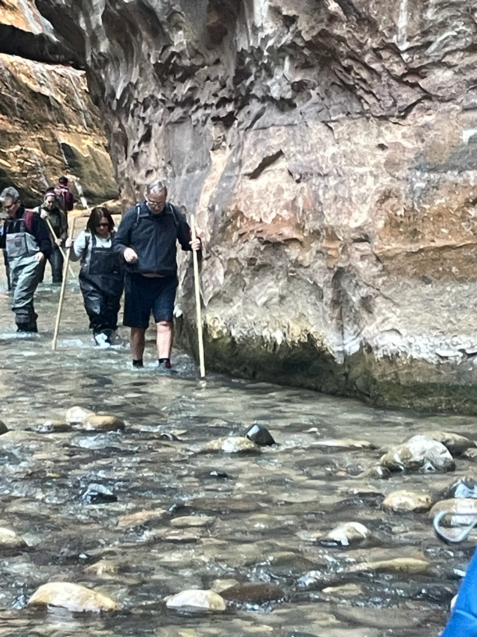
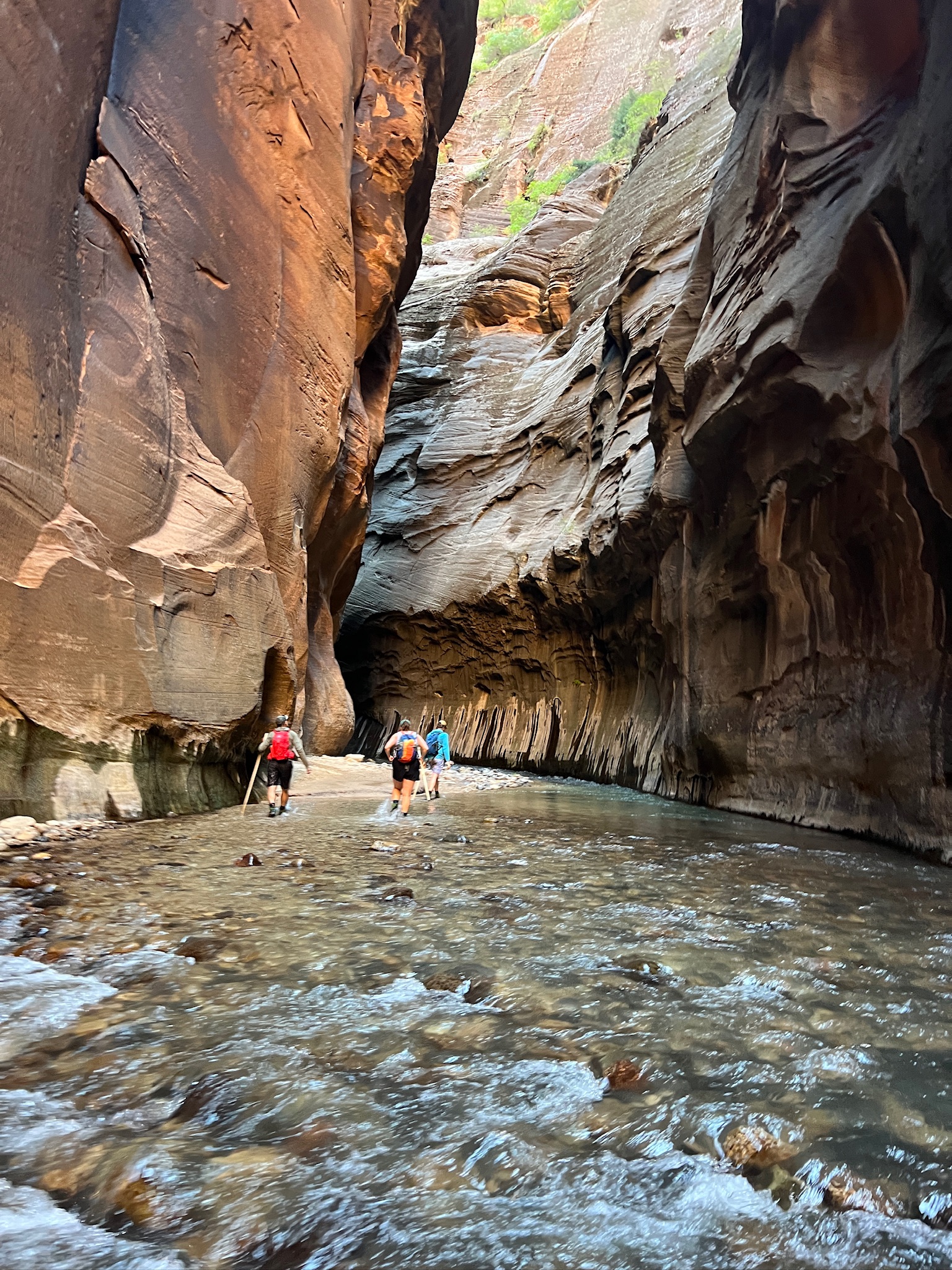
The “Rock Hounds” prepared to set off up The Narrows with our rented neoprene socks, rubber boots and walking sticks.
The infamous “Rock Hound Howl”
Deanne rented the whole-body suit. That’s me on the right hugging the wall and trying to not fall down. I found out that 17 years makes a lot of difference. Becky, me, Liz, and David did this hike in the Narrows in 2007. I remember it being cold but not difficult. Today, because of problems with balance I find it just about impossible. I nearly slipped down several times and was going so slowly that everyone went on ahead except Liz and Deanne who stayed back with me. Once I fell in and got pretty wet and cold I gave up and sat down to rest and dry out. Deanne and Liz went on but did not catch up with the other Rock Hounds.
I sat here waiting for the sun to come up enough to get down in the canyon to warm me up and dry me out. A beautiful place to sit and ponder getting old and feeble…
When we got back to the starting point at the Visitors Center I had no dry socks or shoes to put on because they were in the ‘other’ car. I bought Zion socks at the Gift Shop and crashed when we got back to the rental house.
Couple pics of much younger Liz and David in 2007. Not part of this trip but happy memories. That photo of Liz in the green water is one of my favorites.
Deanne took this pic the next day when she and the kids all rented ebikes in Zion. We wished we could have stayed longer but had to leave Hurricane and the group to head south.
There were two major highlights of this trip. The first was the wonderful family time we had here in Utah. The second was the time at the Albuquerque Balloon Fiesta.
2 of 12 – 2024 Fall Trip West Series. This post covers 6 days of our trip from Clay Center, KS to Colorado Springs, CO.
After our short stop at Marysville, KS and the closed Pony Express Museum we arrived at the Kamphaus farm in Clay Center, KS on September 12th. We enjoyed 4 days “on the farm” as we prepared for the long days driving West. The old farmhouse where Becky grew up is gone but was located just to the left of the swing set in the photo. Becky’s sister Deanne would be travelling with us in our RV and Jennie & Roni would travel along in their RV for much of the trip. This was the first time for us to travel with a third person who would be using the drop-down overhead bunk bed in our RV. We (Deanne) discovered that the original equipment Thor “Cotton Cloud” mattress was not very comfy.
The Farm Animals: “Gabby” (a Great Pyrenees) protects the farm and watches over visitors. She slept right outside the RV each night to keep us safe from coyotes. I think the donkey in the photo is “Daisy” but there are also two others named “Jethro” and “Sadie.” Then there is “Ginger”, a shy puppy that rules inside the house, and of course the chickens. Not shown are a multitude of cats that run around outside.
A highlight event was dinner at the El Puerto Mexican Restaurant with Becky’s family in the Clay Center area. Good food, good company.
A sobering event: we visited the Republican City Cemetery to put flowers on Daniel’s grave. Daisies were blooming nearby. The windchimes had been a gift to Lizzy from her coworkers for Daniel’s memorial service. She didn’t have a place for the chimes so Deanne took them home to Kansas. They make a nice sound at the “old milk barn” where Becky grew up milking dairy cows.
Another highlight was riding in a combine with Becky’s cousin Ron. Ron makes it look easy doing 10 things at once while cutting corn. Here’s a a very wonky video I took of the amazing experience.
Two last pics before leaving Clay Center: The latest downtown ‘mural’ painting on a grain bin is called “Prairie Thunder” by Christian Stanley. It is awesome and so was the sunrise view from our RV. The mural recently won viewers choice in 10th place of “Best Murals of the World” and was the only mural in the top 50 located in the United States. Go Clay Center! Here’s a link to recent mural article: https://kclyradio.com/blog/prairie-thunder-lands-10-in-international-competition-of-best-murals-of-the-world/
The Kamphaus farm driveway is right on US Highway 24. We jumped right on 24 and headed West to a must-see Kansas attraction at Cawker City: “The Worlds Largest Ball of Twine”… circumference 46 feet
We stayed long enough to see the amazing sight… and read some signs explaining the history of the giant ball of twine.
Here’s how it began: Frank Stoeber was born in 1891. At the age of 62, in 1953, he stumbles across some twine and decides to gather it up to burn. Instead of burning it, he decides to roll it up into a ball. He must have enjoyed that, or there wasn’t much else to do in the 50’s (when I was born) because three years later, in 1956 the ball is 7′ around and weighs over 4,000 pounds. It progresses from there. You need to visit for the rest of the story.
Directly across the street (highway 24) was a restored old gas station that was more photogenic than the twine.
Next stop heading West was the National Historic Site Visitors Center in Nicodemus, Kansas. The town was founded in 1877 by recently freed African Americans, mostly from Lexington, Kentucky. It’s the oldest and only remaining Black settlement west of the Mississippi River.
This was an interesting place to visit. The visitors center is the nicest building in what is now a very small, nearly abandoned town. The 2020 census counted 14 people, 78% African-American. Some of the towns people and nearby residents are direct descendants of the original founders. I am so glad we stopped to see the town and learn the history of this place and period of American history. I am also glad my tax dollars are preserving a history that would otherwise by lost.
The founding of Nicodemus is tightly connected to the Homestead Act (visit to that National Historic Site is described in previous post) and Emancipation.
Still traveling West we visited a Kansas geological attraction:
People say “middle of nowhere” all the time but this remote State Park should be the definition. Early settlers called the area “Little Jerusalem” because they thought it resembled the ancient walled city of Jerusalem. Some also called it “Castle City”.
This is Becky’s sister Deanne. She has lived her whole life in Kansas and never visited the Little Jerusalem Badlands State Park. You can’t tell that it is as hot as a furnace outside. I am dying in the heat and she is scampering about, ecstatic to finally visit this place and unfazed by the heat.
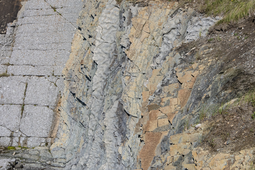
The soft white rock is called Niabrara Chalk. Here at Little Jerusalem it is below the level of the surrounding prairie and easy to understand the formations result from erosion.
Moving on we drove a bunch of dusty dirt roads to arrive at another Kansas geological landmark called “Monument Rocks”. This place is just plain weird. There are no signs, no visitors center. If there was a sign it would say “No Really; the middle of nowhere”.
Monument Rocks Natural Landmark (also know as The Chalk Pyramids). This is the same soft white Niabrara Chalk as Little Jerusalem but it’s just standing up in this one place on an otherwise flat prairie landscape.
There is no parking lot (and no traffic). You just drive up on the dirt road, get out, and walk around. This is an unusual, interesting place to visit. Glad we got to see it.
We met back up with Jennie and Roni (they did not do all the sightseeing we did on this first day) and stayed the night in Colby, KS. We stopped at Walmart on the way out of Colby so Deanne could buy another foam mattress topper for the uncomfortable overhead bunk bed… We continued on to Colorado Springs. But that’s a story for the next post.
We were excited to be first timers at the Gulf State Park we had heard so much about. We had camped once last year along the Atlantic Coast at Jekyll Island but we had never even been to the Gulf Coast. Everything was great; the campground, campsite, friendly campers, and friendly wildlife including several smallish alligators…
Juvenile Bald Eagle. The nest was nearby. John and Pam had shown us the location of the nest the day before. The next day they let us borrow Pam’s eBike and I rode back to check the nest again when this one appeared. I didn’t carry the big camera on the bike so this is an iPhone shot.
This is the view from the overpass that crosses over the highway between the campground and the beach and pier. The eBike was awesome as it powered up the ramp going over and again coming back from the beach.
Not many photos from this part of the trip but we had a great relaxing time at Gulf State Park. We especially enjoyed visiting with John, Pam, and Tim; sitting around John’s propane campfire pit, the visit to the pier with double-red flag warnings due to high surf, and lunch at “Lambert’s” – home of the throwed rolls!
From here we headed to Topsail Hill Preserve State Park which is also along the Gulf Coast. Just a note that the sandy beach here at Gulf State Park is much ‘wider’ and open to the dunes behind the beach. At Topsail the beach is narrow and the dunes are roped off.
On our way to Topsail we found our way to the Pensacola Beach bridge and Fort Pickens, FL. We stopped at the Visitors Center and got a stamp for the Gulf Islands National Seashore which stretches across eight barrier islands along the Florida and Mississippi coast. It was starting to rain so we didn’t stay to explore the fort. We will come back sometime for that and maybe camp at the nearby Ft Pickens campground. Fort Pickens is at the western tip of Santa Rosa Island. Built by slaves using 22 million bricks and completed in 1834 it was intended to defend Pensacola Harbor. Even during the Civil War it remained a Union fort.
As we hustled back to the RV amid sprinkles we spotted this beautiful Great Blue Heron hanging out in the grass.
Stamp in National Parks Passport book
The US Navy Blue Angels are stationed at Pensacola and practice at Fort Pickens area. We heard them a lot and saw them occasionally as we traveled from Gulf State Park to Topsail Hill Preserve State Park.
1 of 13 Jekyll Island Trip. Early spring trip April 4th to May 8th. 34 days
A little post-trip analysis: 2,749 miles by RVparky planned routing, 3,025 actual miles (10% additional) 271.26 gallons of gas. $904.27 for avg cost/gal $3.33 10.735 Avg miles/gal
The 2023 Jekyll Island Meetup is the main goal of this trip. Revisiting with friends we met at last year’s inaugural meetup. Last year there were about 24 Axis/Vegas RV’s. This year there will be about double that and a representative of Thor Motor Coach (Anson Adams) will be attending.
We enjoyed it last year. Jekyll Island State Park is a beautiful place and we learned a lot about our new RV from friendly people having similar experiences. Becky’s sister Jennie had done similar meetups with her Winnebago View RV and enjoyed them.
List of Overnights: numbers match the map tags above 1 – Bowling Green KOA, KY – 1 night 2 – Monte Sano State Park, Huntsville, AL – 3 nights 3 – Gunter Hill Park, Montgomery, AL – 1 night 4 – Gulf State Park, Gulf Shores, AL – 3 nights (visit with John & Pam and see the park everyone talks about) 5 – Top Sail Hill Preserve State Park, Santa Rosa Beach, FL – 2 nights 6 – Three Rivers State Park, Sneads, FL – 3 nights 7 – Suwannee River State Park, Live Oak, FL – 3 nights 8 – Manatee Springs State Park, Chiefland, FL – 3 nights 9 – Jekyll Island State Park, Jekyll Island, FL – 4 nights 10 – Fort Frederica National Monument (in-route Passport Stamp) 11 – Santee Lakes KOA, Summerton, SC – 2 nights 12 – Ninety Six National Historical Site (in-route Passport Stamp) 13 – Cherokee/Great Smokies KOA, Cherokee, NC – 2 nights (begin Blue Ridge Parkway) 14 – Oconaluftee Visitors Center-Great Smoky Mountain National Park (in-route Passport Stamp) 15 – Asheville East KOA, Swannanoa, NC – 2 nights 18 – Boone KOA, Blowing Rock, NC – 1 night 20 – Fancy Gap/Blue Ridge Parkway KOA, Fancy Gap, VA – 2 nights (jump off Blue Ridge Parkway) 21 – Babcock State Park, Clifftop, WV – 2 nights (near New River Gorge National Park)
Then keep following the forward arrows (arrows pointing right →) at the bottom (of the white portion) of each page OR: use the Tab: “PLACES: WE’VE WANDERED” at the top of each page.
We headed back south to Gros Morne. Then we made some day trip visits in and around the park.
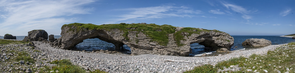
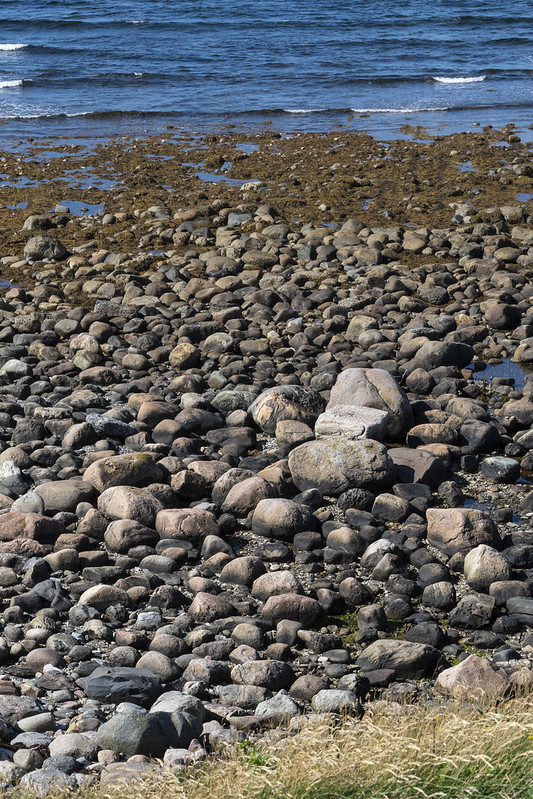
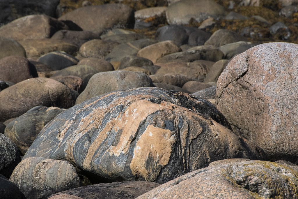
The Arches Provincial Park. A curious rock formation made of dolomite. The rounded boulders that make up the ‘seashore’ were hard to walk on but beautiful.
Beautiful rounded boulders on the beach. Too big to bring home…
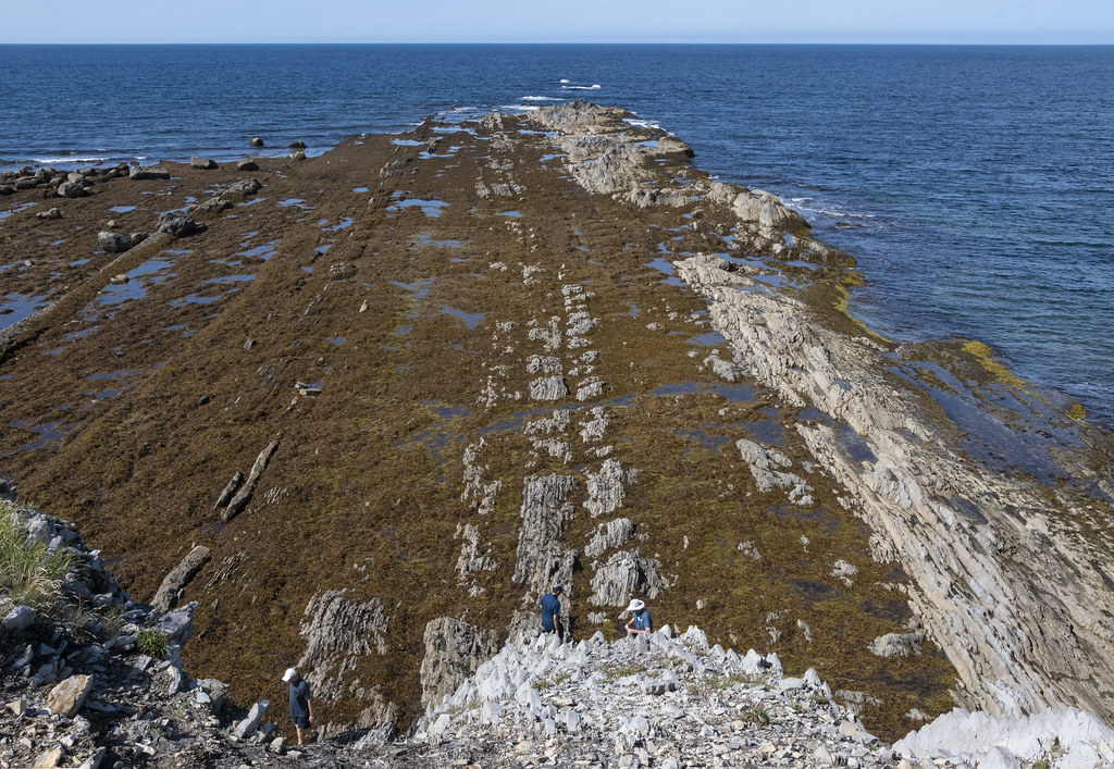
This is the area called “Green Point Geological Site” (that spit of land jutting out in the background). It is part of Gros Morne National Park and is considered a “World Geological Benchmark”. Fossils discovered here define the boundary between the Cambrian and Ordovician periods.
Below: Beach Boulders and Jennie in a Canadian Red Adirondack Chair. “Parks Canada has placed over 200 red Adirondack chairs in peaceful and scenic locations throughout many of the country’s most unique and treasured places”
The view of Green Point from Jennie’s chair
Looking down from the edge
Lobster traps along the coast at Green Point. Labrador is across the water.
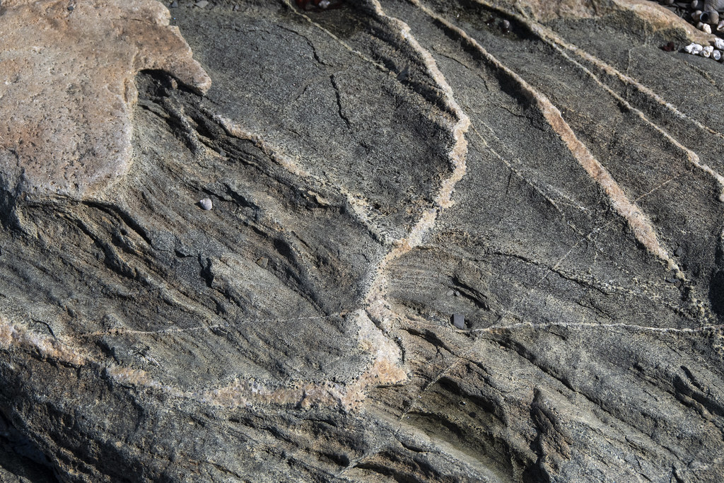
Colorful, Interesting Rocks. Maybe I should have been a geologist…
We visited the Catalina area and enjoyed a walk along a rugged area of Atlantic Coast. Catalina is on the Bonavista Peninsula which is unique for being relatively flat; without cliffs along the shore. When we arrived there was a thick mist coming in and almost a whiteout situation. We walked on narrow paths through a low, mossy/spongy carpet of berries, grasses, and wildflowers.
Manuel Island Lighthouse. A tiny lighthouse on a tiny island in the harbour
Where the moose outnumber the people; they take moose-plows seriously
Roni, Jennie, and Becky; walking in the mist rolling off the Atlantic
Catalina is a ‘working’ fishing town. Not very touristy which was refreshing
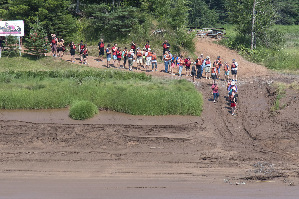
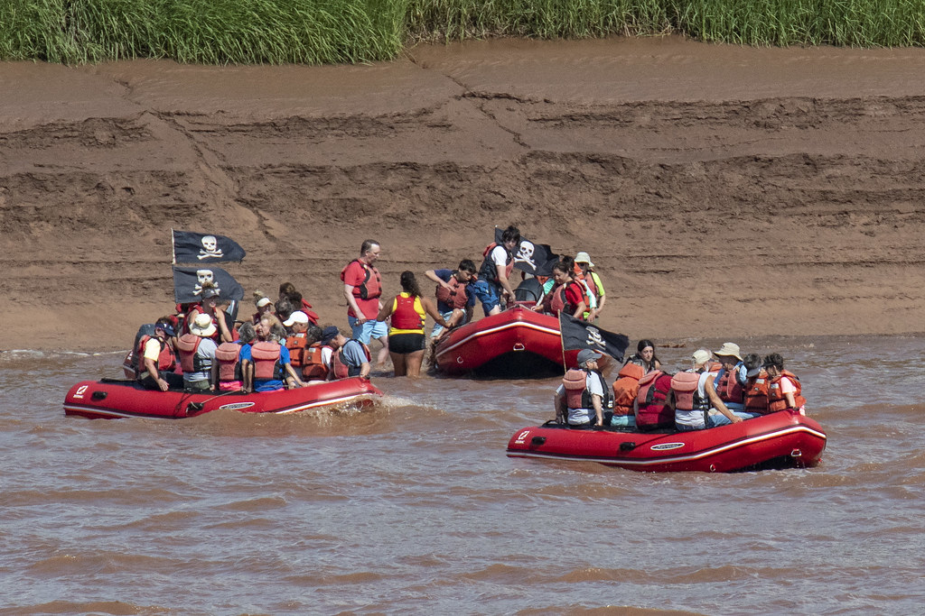
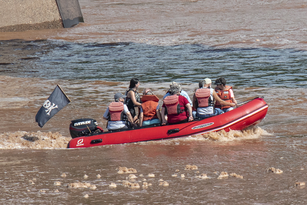
Our group of “caravaner’s” preparing to raft the tidal bore. Jenny went rafting but the rest of us stayed back to watch and take pics. The most exciting part was watching them struggle down the shoe-sucking muddy bank to wait for the rafts to arrive.
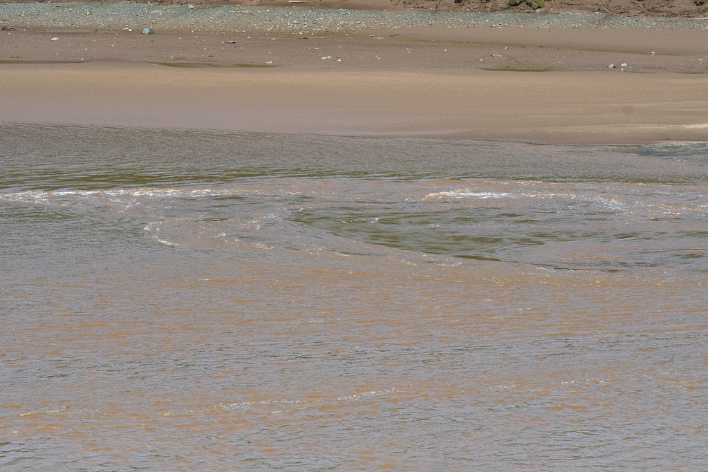
Uh, that water is coming up really fast!
Took a long time to get down the bank. Seemed like there was plenty of time to explore while they wait for the rafts to arrive… At high tide, the water is up to the top of the bank where people are standing (where the dark brown mud turns to light brown dirt)
I think that is Jennie with the baseball hat; seated in back on far left. Understandably; once back at camp she couldn’t wait to shower off the mud. The tune to Gilligan’s Island keeps playing in my head…
Splashing in muddy tidal water. Tide is just beginning to come in. Note the high water line on bank in background… The average tide, around the world is about 3 feet. The tide here can be more than 50 feet. Another interesting trivia bit (per Wiki) is: by volume, twice as much water flows in and out of the Bay of Fundy in a day as ALL the water in all the rivers of the world, combined…
Becky & Paula pose for a quick photo before fast-walking back to the car to avoid being devoured by mosquitoes. Paula is a friend we enjoyed traveling with. She was part of the caravan group and was always ‘on the search’ for lighthouses.
An old photo of the original development. All that’s left now is the lighthouse.
8 mile long Confederation Bridge; opened 1997. It connects two Canadian Provinces (New Brunswick and PEI). There is no cost to cross entering PEI but they get your $50.25 when leaving to go back to ‘the mainland’.
High School swimming is over for another year; just when I felt like I was getting a handle on shooting over a decade of swimming events!
David dropped 4 seconds to swim his best ever (and as a senior, his last ever) 100 yd backstroke; breaking the minute barrier in 57.72 seconds for the prelims and placing 6th in the finals of boys sectionals.
It’s hard to catch a good view of backstroke because heads are mostly underwater and water is flying everywhere. In David’s case that is especially true because he swims more than 50% of the race literally underwater dolphin kicking (as seen in second photo below). David also did really well with his Butterfly but that’s a different story.
Most photos that follow taken at f/3.2, 3200 ISO, 1/800th. Huge thank you to Brian Hall for letting me borrow his 70-200 2.8 again this year!
Here’s a photo of E, J, & K that I caught on Monument Circle.
I share this for two reasons: 1. I like it, 2. It proves we were downtown again on 02/02/2012 with K in a backpack seat, which is the point of the rest of this post…
I occasionally look at the “searched for” info on my wordpress and flickr sites, just to see what brought people to wander in. This morning I saw someone had searched on: “Indy photographer superbowl 2012” and then landed here on wordpress. I put the same terms in a search engine and found that my Super Bowl photo posts come up pretty close to the top of the results list; that was interesting but not terribly surprising.
The surprising part came next… scanning a few of the other search results I noticed a photography post about ignoring the super bowl; intrigued, I clicked on it. I looked through the assortment of interesting downtown Indy photos and was about to move on when a photo of my Son-in-Law and Grandson scrolled into view. WHOW! How?, Who?, Why? What are THEY doing on this guys blog post?
What are the chances?
There were hundreds of thousands of visitors to downtown but on 02/01/2012, some person I don’t know (Rob Slaven):
a. Takes a random photo of my Son-in-Law and Grandson
b. Decides to post it on his blog
c. I ‘stumble across it’ totally by accident while chasing someone elses search string
Here’s the photo: (I’d link it straight to Rob Slaven’s blog but I couldn’t figure out how to do that)
The chances seem incredibly remote, nearing impossibility, but this coincidental serendipity seems to happen to me more often than I would ever expect (see my post titled “Honor or Offense?” Sept 3, 2011 – https://dadartphotography.wordpress.com/2011/09/03/honor-or-offense/)
Well that’s my statistical brain stumbler for the day. Thanks to Rob Slaven for making the day more interesting. It really is a small world out there. I had links to Rob Slaven’s blog but they have all broken and it now says “the authors have deleted this site”
Swimming photos at indoor pools are tough… not much light and flash not allowed.
A new camera (D7000) with much improved high ISO performance, combined with borrowed 70-200 2.8 lens makes things a bit easier. Now the challenge is to get the focus on the right spot as the camera tries to track through all the splashing. I like this one but I may be biased…
This photo at f2.8, 6,400 ISO, 1/500th
When I started this blog a few months ago I hoped it would be a tool to help improve my photography and perhaps identify some links between my profession (Architecture) and my enjoyment of photography. The other day I was watching my daughter hold the camera and remarked that her hold seemed odd to me, at which point everyone else said; “no, you are the odd one”
Thus I learned yesterday (to my surprise) that I fall in the minority of people who use their left eye with a camera viewfinder. A little googling and I found that about 2/3 use the right eye and 1/3 use left. I also learned that the “right brain” controls the left eye and vice versa. Ergo, it seems my left eye dominance indicates a right brain dominance. I had never noticed I was doing something different with the camera… it just seemed the natural thing to do. I am right handed and right footed which is apparently ‘weird’ for someone left eyed.I have never been a big fan of those who claim to have discovered the universal code for “you are the way you are because” (birth order, birth date, etc.) so I will refrain from attaching a great deal of significance to my left eye dominance, but it is interesting and maybe it touches in a small degree on why I enjoy Architecture and Photography? At the very least they are both very creative and very visual endeavors.
Just as there are left handed role models out there for left handed people, I will be content to be left eyed like Joe McNally.